Wicklow and Dublin Mountains in 1812: Richard Griffith’s map for the Bogs Commissioners
Published in 18th–19th - Century History, Book Reviews, Issue 2 (Mar/Apr 2005), Reviews, Volume 13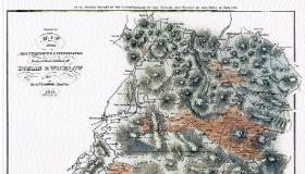 Wicklow and Dublin Mountains in 1812: Richard Griffith’s map for the Bogs Commissioners
With extracts from his report and a commentary
Arnold Horner
(Glen Maps, €12.50)
ISBN 0954303423
The extensive mountain range south of Dublin was once regarded with apprehension by the settlers of the surrounding lowlands, fearful of attack by the ‘wild Irish’, the unpacified clans of the O’Tooles and the O’Byrnes, whose strongholds lay in the upland valleys. As late as 1798, after the rebellion, the Dublin Evening Post could report—perhaps with some exaggeration—that, although only ten to twenty miles from the city, the mountains were ‘as little known to us as any of the wildest parts of America’. By that time, however, mountain landscapes generally were being appreciated for their scenery, and increasing numbers of tourists were travelling out from Dublin to view the Powerscourt waterfall, the Dargle Valley, the Glen of the Downs and other Wicklow beauty spots around the mountain margins.
Richard Griffith’s engraved ‘Map of the mountainous & uncultivated parts of the counties of Dublin & Wicklow’, surveyed in 1812, marks this pivotal point in the recent history of these mountains. With the completion of the military road across the uplands in 1805 their role as an area of refuge was at an end, and soon visitors as well as troops could penetrate more easily into their depths. Griffith’s map was prepared for the Bogs Commissioners and appeared as part of their Fourth Report. Originally at a scale of one inch to one Irish mile, it has now been reprinted at a slightly smaller scale (1:100,000), with extracts from the accompanying report and a commentary by Arnold Horner of the Geography Department, University College Dublin (who is also the publisher).
The map covers the area from Blessington, Saggart and Ballally in the north to Hacketstown, Tinahely and Croaghan Kinshela in the south. On the east it extends to Douce Mountain and Roundwood, but excludes the Calary plateau. Griffith made his own trigonometrical survey of the mountains, and Horner shows that the measurements he gives for eight peaks are relatively accurate. He claimed to have copied most of the roads, particularly those in the lower areas, from Jacob Nevill’s map of County Wicklow of four decades earlier, but he was often content to generalise, using straight lines or over-smooth curves, for instance between Annamoe and Laragh or along the Wicklow Gap road. He has, of course, added the military road, snaking from north to south as far as Aghavannagh.
The survey was a hurried one, however, carried out by a small team over a two- or three-week period in early summer 1812, and in other respects, too, Griffith’s cartography is less accurate and detailed than was Nevill’s. This can be seen in the shape of Lough Dan, for instance, or in his almost rectangular representation of the near-circular Lough Tay. The prime purpose, however, was to paint a cartographic picture of the mountains and bogs, and here the map does, as Horner says, offer ‘a sensitive, impressionistic representation of the main relief features’.
The mountains are shown by hachuring—closely spaced lines running downslope—and the bogs by horizontal lines over a deep brown wash. Griffith also includes a dotted line—now rendered continuous in places by the reduction in scale—to mark the junction of the granite with other rocks; its position, however, has been shown to be far from accurate. One notable aspect is the general absence of trees at the start of the nineteenth century compared with the considerable reforestation that has since taken place. Griffith shows what is apparently natural deciduous woodland extending down the Glencree valley, at the south end of Lough Dan and in a limited number of other places; other woods appear to be demesne plantations, e.g. at Saunders Grove, Humewood and Roundwood Park.
A wide scattering of ‘big houses’, the barracks along the military road and a few antiquities, such as the church ruins and well on Slieve Gadoe (Church Mountain), are included, as are simple street plans of the foothill villages. Horner points out in his commentary that Griffith’s map and his accompanying report incidentally offer important information about the human impact on the mountains. In some places the enclosed area was increasing; others, such as the Glen of Imaal, had ‘formerly been in a much higher state of cultivation’. The map implies that the exposed upper slopes had no permanent inhabitants at the start of the nineteenth century, just as today; it is silent on the question of whether they were used as summer pastures with temporary dwellings.
The booklet that here accompanies Griffith’s map runs to 36 pages, with Horner’s detailed commentary, lengthy extracts from Griffith’s report, two appendices reprinting comments on the bogs and a description of Glendalough in 1801 by Robert Fraser, acknowledgements, notes and references; it is illustrated with modern black-and-white photographs. Map and booklet are attractively presented in a plastic folder. This is the third in Glen Maps’ reprint series, following two by Alexander Nimmo, also for the Bogs Commissioners: Iveragh in 1811 and Kenmare River in 1812.
Mary Davies