‘To perfect a map of the whole realm’
Published in Features, Issue 6 (November/December 2019), Volume 27Robert Lythe’s maps of Ireland 450 years ago.
By Arnold Horner
When Robert Lythe arrived at Carrickfergus in late September 1567 he almost certainly did not appreciate that he was on the cusp of a heroic enterprise that would involve him in mapping large parts of Ireland, travelling on horseback and otherwise aided only by guides, a servant and, on occasion, a small escort. His work was spread over several years and ultimately resulted in a greatly enhanced image of Ireland—an image with well over 1,200 place-names that, two decades later (and for long after), would be the source for the printed maps produced by such great map publishers as Hondius, Mercator, Boazio and Speed.
Initiative of William Cecil
Shane O’Neill’s rebellion had ended with his death, and the government in London, most notably Queen Elizabeth I’s secretary of state and chief fixer, William Cecil (later Lord Burghley), contemplated a way forward. Following the conclusion that little could be done until the queen had received ‘a more particular description than we have by any c[h]art’, the lord deputy, Sir Henry Sidney, requested for ‘one to be sent over to make a plat[e] of Ireland’. On 23 August 1567 the privy council in London commissioned Lythe ‘to perfect a map of the whole realm’. He had perhaps been recommended by John Challoner, secretary to the Irish council, who had met Lythe a decade earlier when, as a military engineer, Lythe had been employed to map the English enclave, then in its final years, at Calais.
Lythe’s start in Ireland was inauspicious. Within six days he had made two maps of what was effectively another English enclave, around Carrickfergus, but the plan to map more of Ulster proved difficult to implement as winter approached. Writing in November 1567, Challoner noted how Lythe had faced ‘short days, dark and foul weather, and the boggy mountains as well as every valley full of mire and water …’, adding that the season was ‘also more opportune there for the Irish outleaps, stealths and spoils, secretly always suborned and winked at even by those that bear the civilest face …’. Moreover, Lythe lacked ‘the travel of such company as should have guided and safe conducted him from place to place whereby he might perfectly have done that he came to do, hath not now been so propice [propitious] for his enterprise nor for the captains to attend him … as the summer season would be …’. Lythe therefore made the journey from Carrickfergus to Dublin, ‘a foul and heavy long way on foot with the soldiers and his boget [bag] as he told me on his back, which travel might with the friendly loan of a nag have been eased … ’.
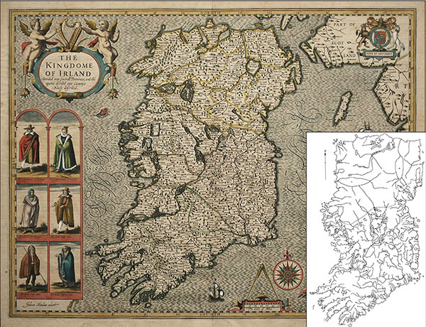
Above: John Speed’s 1610 map of Ireland and (inset) John Andrew’s map from Imago Mundi (1965), showing the detail in areas covered by Robert Lythe’s c. 1571 map. Although extra information was added to Ulster, the outline of Ireland determined by Lythe continued to be used on Speed’s printed map, made nearly 40 years later. (British Library)
Surveyed south of a line from Strangford to Killary Harbour
Lythe was allowed leave for England but returned to Ireland in November 1568, with his wages doubled to eight shillings a day while in the field, plus a servant allowance of one shilling. On this occasion he would remain in Ireland for two further seasons, followed, from October 1570, by a long period in Dublin working on his map. He finally left Ireland in November 1571, subsequently submitting a very detailed account of his expenses, which, in addition to his daily allowance, had amounted to £149-17s-10d, much of it for the hiring of guides who were also, presumably, interpreters. During his time in the field, he started and ended in Strangford, traversing much of the country south of a line between there and Killary Harbour. Further north, however, was considered too ‘unquiet’, and perhaps also too physically demanding, to survey. Lythe was, in any case, in his own words, ‘lame and almost blind’ and in no condition for further fieldwork.
The expense account gives a clear indication of the sequence in which, and where, Lythe made his surveys, showing also that his work was interrupted on two occasions when his services were requisitioned by the lord deputy. Particular attention appears to have been paid to the south-west, an area of emerging significance in the context of north Atlantic geopolitics, most notably rivalry with Spain. In addition to land surveys through various lordships, boats were hired for surveys of some of the main havens, notably Cork and Kinsale harbours, the Kenmare River and the Shannon estuary. Using a pinnace with 40 men, a longer journey was also undertaken, at a cost of £6 for victualling, from Kinsale to Dingle. The agenda en route included searching ‘every creek and haven by way as also every island and haven within the … bay of Baltyntenmoore’ (Baltimore). A leather boat, presumably a currach, with three men and a guide, was hired from ‘Dyngelldecushe’ (Dingle) to ‘search’ the great river of ‘Mayore’ (Kenmare), the Skelligs, the Blasket sound, Ventry haven and on up the bay towards Castlemaine.
Visual surveys
Above: Dublin Bay as it appears on the Petworth map, with comments on the entry channel and on the coast at Howth, Robswall and Corballis. North is to the right. (Lord Egremont, Petworth House Archive, West Sussex)
The surveys undertaken during these journeys must have been almost exclusively visual, aided by compass bearings. So much ground was covered in such a short time, with very limited support, that it would have been impossible to undertake much in the way of a more formal survey. As well as fulfilling his main objective of mapping large parts of the country, Lythe appears to have responded to government requests to produce a number of more specific maps, among them ‘a single draught of Munster’ and a map of Idrone (south Carlow). As Professor John Andrews has shown, up to a dozen maps, not all of them now extant, can be linked to Lythe’s time in Ireland.
When he returned to Dublin in October 1570, Lythe battled illness and began work on an enormous map of Ireland for which special tables and trestles were made at a cost of twenty shillings. As he reported to Burghley in March 1571, Lythe had taken, during his fieldwork, ‘the true bounds and limits of every particular province and shire and chief lordships … as nigh as I can gather them by the information of the country and my own knowledge and judgement; also every notable towns, castles, rivers, havens, creeks, loughs, mountains and woods therein contained and other commodities …’. His large ‘plat’ would now display many of these features, for it would be ‘in length 8 foot and a half and in breadth 5 foot and a half [2.6m x 1.7m], to the intent by that largeness the most notable matters may be showed therein, notwithstanding here is no good painter in this land to set it so well forth …’.
For this map, Lythe had to address the fact that he had made no field surveys of his own across most of Ulster and northern Connaught. He met this issue by grafting less detailed and less accurate data from earlier maps onto the more detailed map that he could compile for the two-thirds of the island that he had himself surveyed. As Andrews showed over half a century ago, the result, which is evident in the later printed maps derived from Lythe, is an Ireland of two parts, with the lack of detail for the north perhaps accurately reflecting the general lack of knowledge about Ulster in the late sixteenth century. (p. 21)
Unfortunately, this particular map is now long lost, possibly having disappeared before the end of the seventeenth century. Smaller-sized versions were made, however, including those that made their way to the map publishing houses of Europe. One such version, now partly defaced, is in the British Library. Another, unsigned and undated but perhaps mid-1571, is at Petworth House in Sussex and shows only those areas that Lythe himself had covered (i.e. the area south of a line from Killary Harbour to Strangford).
The Petworth map is highly variable in its local detail and cannot be considered in any way consistent in its coverage. It is, after all, the product of one man’s rapid appraisal of a large tract of country. Thus some rivers take odd courses and no detail is given for Ely O Carroll and Ormonde, both lordships where a ‘perambulation’ had not been made. Nevertheless, the map contains over 1,200 place-names, many with a challenging orthography, together with some extensive, and sometimes distinctive, local detail. The names of most of the villages and places in the vicinity of Dublin, then a small, compact place with perhaps ten or fifteen thousand inhabitants, are readily recognisable today. (p. 21) Historians and others in Galway (and elsewhere) may, however, wish to contemplate the identification of the mountains of north-west Connemara as ‘Magher ladorlats the devylls balocks xii great hylls or mountains’ (!).
Occasionally there are distinctive symbols; for example, a large cross is placed at what is presumably Mount Leinster—an area Lythe knew from his Idrone work but an unusual marker for a map being prepared for the highest authorities in Protestant London. The comments, some of them quite lengthy, are a more widespread feature of the map. West of Roscommon town, for example, it is noted that ‘this wood is great oaks and much small woods as crab-tree, thorn, hazel and such like’. (p. 22) Further north, the ‘plain fields of Connaught’ are marked, whilst further south, near the west bank of the River Shannon, roughly in the section between Clonmacnoise and Athlone, are woods marked ‘most part great oaks’. Far to the south, Sliabh Luacra (‘Slew Logher’) is described as ‘a vacant place where is little habitation, with small glens and no great mountains but that it might be made good arable ground’.
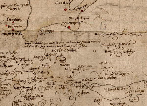
Above: West of Roscommon town (north is to the right) it is noted that ‘this wood is great oaks and much small woods as crab-tree, thorn, hazel and such like’. (Lord Egremont, Petworth House Archive, West Sussex)
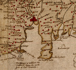
Along the coast, the characteristics of sections of the shoreline (whether rocks, cobbles, pebble, clays or flat sands) and the principal harbours (whether with or without a bar blocking the approach) are given particular attention and are described perhaps as they might be seen or accessed from the sea. The rich fishing grounds of the south-west are the subject of several notes—for example, the Kenmare River, ‘wherein is great plenty of fish and divers fair havens, and plenty of salmon’, Dingle Bay and Baltimore Bay, which is noted as ‘a good road for ships’ between its islands. Historical associations are given in two instances. Near ‘Baginbond’ and ‘Banagh haven’ in south Wexford a small cross marks ‘where English men first landed’, i.e. the site of the invasion in 1169. Much further west, at seven castles near Timoleague, ‘where the chefe captaynes of the mahowmets Landed’ is presumably an allusion to some sort of encounter with North Africa well over 60 years before the now-renowned 1631 ‘sack of Baltimore’. (p. 23)
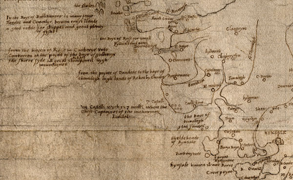
Above: The south Cork coast between Timoleague and Baltimore. The lowest of the four comments to the left includes the words ‘vii Castells … where the chefe captaynes of the mahowmets landed’—an allusion to some sort of encounter with North Africa, 60 years before the now-renowned ‘sack of Baltimore’ in 1631. (Lord Egremont, Petworth House Archive, West Sussex)
The work of Robert Lythe, and the Petworth map in particular, deserves to be appreciated and incorporated into the historical narrative on sixteenth-century Ireland. In the judgement of the historian of Irish cartography Professor John Andrews, ‘Lythe transformed the map of Ireland to a degree unequalled by any other cartographer except William Petty’.
Arnold Horner formerly lectured in Geography at University College Dublin.
FURTHER READING
J.H. Andrews, ‘The Irish surveys of Robert Lythe’, Imago Mundi 19 (1965), 22–31.
J.H. Andrews, ‘Robert Lythe’s petitions, 1571’, Analecta Hibernica 24 (1967), 232–41.
R. Dunlop, ‘Sixteenth-century maps of Ireland’, English Historical Review20(1905), 309–37.
W.J. Smyth, Map-making, landscapes and memory: a geography of colonial and early modern Ireland c. 1530–1750 (Cork, 2006).