The Dead Sea, whose surface is today about 417m below sea level, is not only the lowest place on the surface of the planet but also one of the most inhospitable. Its water is poisonous to drink, it is excessively hot for many months of the year, it is surrounded by steep and barren mountains, and it is a place of strange natural sights: floating globules of bitumen, lumps of sulphur around its shores, and curiously shaped formations—usually referred to as ‘pillars’—of rock salt.
References in earliest written sources
Curiosity about this strange place can be traced back to our earliest written sources for the region. Stories to explain the landscape and its bizarre mineral features found their way into the Bible (Genesis 19) in the form of the destruction of the cities of Sodom and Gomorrah, located in the valley that is now the Dead Sea—and just to make this more confusing, the word ‘valley’ was mistranslated as ‘plain’, so these cities became known to generations of English-speakers as ‘the cities of the plain’. The idea that a vengeful God had destroyed these cities with ‘brimstone and fire’ was enough to explain the presence of the bitumen, and then the valley filled with water to remove the memory of these cities and it became known as the Salt Sea. The story also told how Lot and his family were allowed to escape to nearby Zoar—indeed, the whole biblical story centres around Lot—but he was warned that the family must not look back as they fled. Curiosity, alas, got the better of Lot’s wife; she looked back and was punished by being transformed into a pillar of salt (Gen. 19:26)—and that explained another natural feature. Most of the Lot story was incorporated from the Book of Genesis into the Koran (11:81), and so for the Muslim inhabitants of the region it is still known as Bahr Lût (Lot’s Sea). In Roman times it became an important source of asphalt and became known as the ‘asphaltic lake’, but all the while the legend grew that nothing could survive in or on its waters: it was a place that reeked of death. From this legend came the name the ‘Dead Sea’, which entered European usage through the Latin Bible in the late fourth century and has remained its common name in every European language to this day.
So strong was this legend that one could not enter the lake and live that as late as 1816 two British naval officers, Commander Charles Leonard Irby and Captain James Mangles, were prepared to travel right around the lake but unwilling to set out upon it to plumb its depth or find explanations for its abundance of various minerals and salts. It is against this background of uncritically accepted biblical history, growing geological curiosity but persistent fearful legends that it was a place of death that we have to view the first recorded exploration of the lake.
‘The unfortunate Costigan’
In August 1835 Christopher Costigan—invariably referred to as ‘the unfortunate Costigan’ in nineteenth-century sources because of the difficulties he encountered—arrived in Beirut determined to survey the Dead Sea. He bought a boat and hired a Maltese sailor as crew. Already we see the blunders of the amateur: August is the wrong time of year for the Dead Sea, when it is at its hottest. Why buy the boat in Beirut, when it would have to be moved by sea to Acre and then transported a very long way overland? Waiting until he was in the region to decide about the crew—and then hiring just one man—shows how ill-prepared he was; there is no evidence that he had given any real thought to logistics, nor had he any training in either seamanship or surveying. He was lucky, however, in the sailor he hired, who stuck with him through thick and thin and later set down Costigan’s story. Without him,

Costigan would have disappeared without trace.
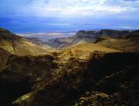
The Dead Sea in the Atlas of the historical geography of the Holy Land by George Adam Smith and J.G. Bartholomew (1915), showing (inset) Point (nowadays Cape) Costigan, Point Molyneaux and the biblical city of Zoar.
Costigan set out, via Acre, for the Dead Sea, and imagined that he would be able to row down the Jordan at the time of year when the water is lowest. When that failed, the two travellers set out overland for Jerusalem, and were then confronted by bandits. Costigan tried to draw his sword, but it was rusted and the hilt broke off in his hand! For once he was fortunate: the bandits cleared off and the two ‘explorers’ continued onwards. Eventually, on 26 August, he was ready with his boat and crewman to start out on the Dead Sea. Although Costigan did not keep a journal, the sailor reported that he began criss-crossing the lake taking soundings, and that night they camped on its eastern shore. The next day they travelled at least 16km south to the mouth of the River Arnon and spent the night anchored offshore north of the peninsula called El-Lisân (‘the tongue’), which juts into the lake from its eastern shore. The next day, 28 August, he landed on the point of land that would later bear his name. On the 29th they rowed into the southern part of the lake and Costigan examined ruins at En Boqeq. This last item is important for understanding Costigan’s motivation. En Boqeq is near where it was thought the biblical city of Zoar was located—and that was the ‘nearby’ city to which Lot fled (Gen. 19:20–22). Costigan’s interest in those ruins suggests that he was interested not only in geography but also in the biblical story. He, like other biblically inspired travellers in the area, thought that these ruins were those of Sodom or Gomorrah.
The following day the Dead Sea lived up to its reputation: Costigan became ill and could row no further, but somehow they managed to reach the northern shore and camped there on 1 September. The following day he was brought to Jericho and was growing weaker. Costigan then sent a message to Jerusalem with his sailor, begging any European he could find to come and help him. The message reached an Anglican
 missionary stationed there, the Revd John Nicolayson, who immediately, at 9pm, set out along the dangerous road to Jericho to help him. Costigan was now dying, but whatever hope he had lay in being brought to Jerusalem; the intrepid Nicolayson got him there by 8am on 5 September, lodged him in the Franciscan Hospice and got him a physician. It was in vain, however: Costigan developed a fever, received the last rites from the Franciscans and died early on the morning of 7 September; he was buried later that day. He was 25 years and five months old.
John Nicolayson contacted Costigan’s mother in Dublin, and, most importantly, sought out as much information as he could about Costigan’s exploration and published it. Nicolayson’s courage and generosity deeply affected Mrs Costigan—who was struck by the parallels between the help he offered her son, going down from Jerusalem to Jericho, and the Gospel story of the Good Samaritan (Lk 10:30–5)—and she thanked him in her son’s epitaph, referring to him as ‘a certain good Samaritan’. Because of Costigan’s bravery, coupled with his misfortune and his ‘Good Samaritan’-style rescue, his story became well known to those with an interest in the Holy Land at the time. But the Dead Sea itself would keep its secrets for a little longer.
The aftermath
The next expedition was mounted in 1847 by Lt Thomas Molyneux RN and, by comparison with Costigan’s, it was a well-equipped party of naval ratings led by a man of proven surveying ability. It followed a route very similar to Costigan’s and at the same unfavourable time of year. Like Costigan, he set out on the lake plumbing for the depth and on 3 September found a maximum depth of 1,350ft—so to him goes the credit for the first recorded depths for the lake. Just two days later, however, exhaustion forced them to abandon the survey. Although the party returned to
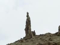
One of the Dead Sea’s curiously shaped formations—usually referred to as ‘pillars’—of rock salt.
their ship, Molyneux did not shake off whatever illness he had contracted on the Dead Sea and died on 30 October.
The following spring another naval expedition was mounted by Lt William Lynch of the United States navy. Lynch’s party was by far the best equipped of any that operated in the Levant up to that time, and he combined brilliant surveying skills with an interest in geology and the Bible. From Lynch’s work emerged not only the modern map of the lake and its depths but also the knowledge of just how far below sea level the shore of the Dead Sea is. Lynch knew well the stories of Costigan and Molyneux—indeed, he followed Costigan’s route to the Dead Sea—and he noted, for example, at En Boqeq: ‘Here Costigan thought he had found the ruins of Gomorrah’. Lynch was also aware of his predecessors’ achievements in getting boats to the lake and setting out to survey it, so as he was mapping the El-Lisân peninsula on 26 April 1848 he fired a salute in their memory and named its northern extremity ‘Point Costigan’ and the southern extremity ‘Point Molyneux’. Unlike his predecessors, Lynch survived and returned home, wrote two accounts (one scientific, one popular) of his adventures, and died in his bed in 1865. The spell of the legend of the Dead Sea was finally broken. HI
Thomas O’Loughlin is Professor of Historical Theology at the University of Nottingham.
Further reading:
C. Costello, ‘Nineteenth-century Irish explorers in the Levant’, Irish Geography 7 (1974), 88–98.
E.O. Eriksen, Holy Land explorers (Jerusalem, 1989).
E.W.G. Masterman, ‘Three early explorers of the Dead Sea Valley’, Palestine Exploration Fund Quarterly Statement 43 (1911), 12–27.