The English Pale:a ‘failed entity’?
Published in Anglo-Norman Ireland, Early Modern History (1500–1700), Early Modern History Social Perspectives, Features, Gaelic Ireland, Issue 2(March/April 2011), Medieval History (pre-1500), Medieval Social Perspectives, Volume 19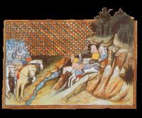
The forces of Art Mac Murchada sally forth from a ‘wild’ mountain landscape to engage the ‘disciplined’ ranks of the earl of Gloucester—a stereotypical image of the clash of two cultures as depicted by Jean Creton, a Frenchman who accompanied Richard II’s expedition to Ireland in 1399. (British Library)
It is hardly surprising that Irish historians have been reluctant to engage with negative later medieval English perceptions of Ireland (see sidebar below), other than to impugn their veracity. In regard to the English Pale, for instance, studies of interaction between Gaedhil and Gaill have aimed to disprove its status as an international frontier; depictions of a shrinking ‘English ground’ call into question its military efficacy; and accounts of ‘English degeneracy’—the spread of Irish customs among the English—take from its significance as a cultural barrier. Moreover, what was a Tudor borderland with a fiercely English identity later became a core territory of an Irish Free State, which was at pains to downplay this same English heritage. Thus there are no exhibitions of Pale culture nor monuments to the Palesmen’s exploits, because, to borrow a later phrase, the English Pale was, allegedly, ‘a failed entity’.
National agenda
This national agenda has tended to stress the thoroughgoing nature of the settlers’ dealings 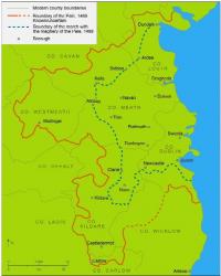 with the Gaelic
polity, their supposed Irishness and ‘Gaelicisation’, portraying instead two varieties of Irishmen
(‘Anglo-Irish’ and ‘Gaelic Irish’) interacting across a dissolving frontier. It also replaces contemporary Tudor terminology, which substantiates the Pale’s frontier status and its perceived ‘civility’, with a more congenial—but unhistorical—vocabulary that reflects a modern aspiration to national unity. And attempts to redress the balance by looking more closely at developments in the English Pale and the settlers’ English identity have been dismissed perjoratively as a variation on the ‘two-nation theory’. All this is unfortunate for two reasons. First, to be English conveyed certain rights and privileges as the king’s subjects (whether born in Ireland, Wales or England): in the Pale, discriminatory legislation against ‘the king’s Irish enemies’ was actively enforced. And given the frontier context—two nations, laws and cultures, and a pervading rhetoric of difference—the Palesmen were highly sensitive to their English identity, because to be English was to be free and civilised, whereas Irishness was synonymous with servitude and savagery. It is, in any case, a nonsense to talk about ‘Anglo-Irish subjects’: there was no such legal category. Second, during the later phase of Tudor expansion, English incomprehension of the refusal of that ‘stubborn, rude and most barbarous people’ to embrace the benefits of ‘English civility’ so magnanimously offered helps to explain the more brutal treatment of ‘the wild Irish’ that followed.
And the fact remains that the English Pale was not ‘a failed entity’! It was an effective military device that
followed tried and tested methods of English government, notably in the Anglo-Scottish border region, so much
![A sixteenth-century map of the English Pale at Calais. By 1494, when Sir Edward Poynings and his military retinue were redeployed to Ireland from Calais, conditions in ‘the four obedient [Irish] shires’ were already much improved on the situation a half-century before.](https://www.historyireland.com/wp-content/uploads/2013/02/84_small_1299511914.jpg)
A sixteenth-century map of the English Pale at Calais. By 1494, when Sir Edward Poynings and his military retinue were redeployed to Ireland from Calais, conditions in ‘the four obedient [Irish] shires’ were already much improved on the situation a half-century before.
Distinction between a ‘pale’ and a ‘march’
Traditional accounts of ‘the emergence of the Pale’ present it as the product of long-term English decline, but this is perhaps to confuse two somewhat different defence strategies. The later medieval English lordship has been well characterised as ‘a land of many marches’; but a march was a militarised borderland with shifting boundaries, whereas a pale was a defensive ring of fortifications enclosing a precisely delineated area. In the English marches crops were easily burned, and isolated or undefended villages soon fell victim to Irish raids. After 1300, too, demographic decline and the shift to pastoralism meant fewer tenants to organise defence, prompting the abandonment of marginal manors and the appearance of wastelands. In the fifteenth century, therefore, the Dublin administration focused resources on the English heartland around Dublin, ‘the four obedient shires’, where conditions were more favourable to English rule. This well-populated region of mixed farming proved a much more defensible ‘land of peace’, increasingly described as the ‘maghery’ (‘plain’), with nucleated villages cited sufficiently close to each other to provide mutual defence, and underpinned by a solid framework of major castles and (walled) market towns, and further insulated by the marches. Gradually, the existing defences were strengthened by the fortification of bridges and the erection of small castles or towers in the marches at key points of entry; and encouraged by local subsidies, the nobles and gentry were persuaded to build similar towers to protect their landholdings. Concurrently, steps were taken to build a system of earthen dikes and ditches to inhibit cattle-rustling. This culminated in a statute of 1495 requiring English marchers to ‘build and make a double ditch of six foot of earth above the ground’ where their land ‘joineth next unto Irishmen’, with other ‘ditches in the wastes or fasaghe lands without the said marches’.
Military service
The next step was to define more precisely the boundary between the marches and the maghery so as to define the inhabitants’ traditional obligation to military service. In wartime, the more sparsely populated marches needed extra troops for defence, and Irish kern and horsemen were cheaper than their English counterparts. The difficulty here was to regulate arrangements so that they did not degenerate into a system of wholesale free billeting akin to practice in the Irishry, the much detested system of coign and livery. Accordingly, the precise bounds of marches and maghery were delineated and confirmed in 1477 by statute. Then, in 1488, parliament passed the Act of Marches and Maghery: this proscribed as a felony the taking of coign and livery throughout the four obedient shires, except by landowners on their own tenants in the marches. The resultant arrangements for defence are described by Baron Finglas in his well-known reform tract. Whenever the deputy and council proclaimed a hosting, each landowner was required to send an able man with jack, sallet, bow and arrows for every £20 of income a year; but in the marches the landowners were to send only one horseman for every ten marks of income and meanwhile, in the case of County Meath, collectively to ‘cess on their march lands 120 kerne’, electing a captain to lead them. For each hosting, the English inhabitants of the maghery were to carry bows or wear armour, and not to bring spears instead. The bowmen were to march on foot, and no yeoman was to ride on horseback.
By 1494, when Sir Edward Poynings and his military retinue were redeployed to Ireland from the English Pale at Calais, conditions in ‘the four shires’ were already much improved on the situation a half-century before. By the time the lord deputy had taken stock of the military situation and ordered the building of new dikes and ditches, the four shires more closely resembled the Calais Pale than a march. Thus the resultant statute was headed: ‘for ditches to be made about the English Pale’. This, the first use of the term ‘English Pale’ with reference to ‘the four shires’, also constituted a significant value judgement by this English official. Not only was this a physical frontier, a precisely delineated area screened by a ring of fortifications, or cordon sanitaire—a Pale, in other words—it was also recognisably English and civil.
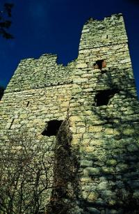
In the late fifteenth century existing defences were strengthened by the fortification of bridges and the erection of small castles or towers in the marches at key points of entry, such as this one at Kilgobbin, south County Dublin. (Chris Corlett)
Growth of tillage
It is not hard to imagine why, given his background and training, Lord Deputy Poynings conceived of the region in these terms. By the mid-1490s, the Pale’s new fortifications and the reorganisation of militia service in the region was having a noticeable impact on the levels of tillage there. The growth of tillage reflected more stable political conditions, and tillage was also a key marker of civility. This is clear from assessments for the Irish parliamentary subsidy, the chief form of direct taxation in late medieval Ireland, which was levied on ploughlands of cultivated arable land. Between 1479 and 1500 the overall assessment for the Pale had risen from 793 to 831 ploughlands, and it continued to rise into the 1530s. In County Meath, for instance, the assessment rose from 276 ploughlands in 1479 to 299 by 1499, and 344 by 1533. Some of the baronies in the Pale maghery showed spectacular increases, from 24 ploughlands in each of Dees and Kells to 31 and 30 respectively, and from 16.5 to 23 in the case of Lune, although in the marches of west Meath, where Irish raids remained a threat, the assessments increased only slightly and from a very low base. By the 1520s, too, the maghery was so secure from Irish raids that, as one official complained, the major landowners there keep ‘little ordinary houses, as [if] they were in a land of peace’, leaving the burden of defence to the poor march gentlemen. Overall, the levels of tillage were, by the 1530s, 25% higher than they had been 60 years before.
Other evidence points in the same direction. In 1488 the parish of Laracor and the erstwhile border town of Kells in Meath and the town of Kilcullen, Co. Kildare, which a generation before had been described as lying in the frontier of the marches, were now within the bounds of the Pale maghery. And scrutinising the records of Duke Richard’s liberty of Trim and the exchequer, Undertreasurer Hattecliffe had concluded in 1495 that the eleven fairly large manors of the lordship were unlikely to be worth more than £229 a year. After 1534, when the manors were almost all in the king’s hands again, their best value was estimated at £400. Further west, lands among the king’s ‘Irish enemies’ and English rebels, which had long lain outside the formal baronial structure of the shire but had been recovered by the earls of Kildare, again yielded rents to the exchequer following the Kildare rebellion: manors now worth over £75 a year in all in Maghirquirke (now Kilkenny West), Kineleagh and Fartullagh—all in parts ‘within County Meath where, however, the king’s writ does not run’. And when the diocese of Meath was assessed for first fruits and twentieths by the king’s commissioners c. 1539, this new taxation included the deanery of Loughsewdy, where, for instance, the rectory of Loughsewdy was taxed at IR£16 per annum, the rectory of Newton in Fartullagh at IR£2 3s. 4d., and the rectory of Rathconnartie at IR£13 15s. 0d. Physically, too, Fartullagh had since been integrated into the Pale’s frontier defences: a ditch had been erected, extending through Farbill and Carbury, and into Meath as far as the Boyne.
Meath and Westmeath
By the 1530s, therefore, the king’s peace stretched further and English rule was effective over a much wider area of Meath than had been the case in the 1460s. In the early Tudor period, however, these districts lay outside the shire’s formal baronial structure, so that the king’s writs and process could not be executed there. The rectification of this anomaly was one of the aims of an ‘Act for the division of Meath’ passed in 1542. This statute noted that because Meath was ‘great and large in circuit, and the west part thereof laid about and beset with diverse of the king’s rebels’, the king’s writs and laws were disobeyed in several parts there ‘for lack of ministration of justice’, particularly ‘in diverse places of the west part’ where the inhabitants had formerly been obedient. Accordingly, the shire was now divided into two shires, Meath and Westmeath; and in Westmeath four new baronies were established in the far west on the lands of the English marcher lineages: Dalton’s country became the barony of Rathcomyrte (now Rathconrath); Delamare’s country, Moybreckry, was made the barony of Rossaughe (later Moycashel); Tyrrell’s country became the barony of Fartullagh; and Dillon’s country, Maghirquirke, was now the barony of Kilkenny West. Significantly, too, the new shire town was Mullingar, which, 80 years earlier, had been a beleaguered outpost in the extreme west periodically burned by the Irish. Within ten years, too, Thomas Tyrrell, chief captain of Tyrrell’s country, had been knighted and appointed to the peace commission: Tyrrell, the English rebel, had become Sir Thomas Tyrrell, JP.
The statute creating the shire of Westmeath thus crowned the success of this policy of erecting a frontier to defend ‘English ground’. It also rendered obsolete the region’s earlier designation as ‘the four shires’: the statute referred instead to this new entity, ‘the English Pale’. Of course, it had been in the interests of the king’s officers to claim that the English Pale was shrinking and English order and rule collapsing, so as to induce the king to come to the rescue with money and men. But historians have been far too ready to believe such ex parte statements. As for ‘two-nation theory’, the idea of erecting a fortified frontier to defend English ground and the English nation from foreigners was actually a proven strategy, long used against the Scots. So ‘two-nation policy’ would be more accurate; but ‘two-nation theory’ at least shows a better appreciation of medieval English concepts of citizenship than the theory of ‘Anglo-Irish subjects’. HI
Steven Ellis is Head of History at NUI, Galway.
Further reading:
R.R. Davies, The first English empire: power and identities in the British Isles, 1093–1343 (Oxford, 2000).
S.G. Ellis, ‘Civilizing the natives: state formation and the Tudor monarchy, c. 1400–1603’, in S.G. Ellis and Lud’a Klusáková (eds), Imagining frontiers: contesting identities (Pisa, 2007), 77–92, or http://www.cliohres.net/books2/ books.php?book=5.