The Earliest World Maps Known in Ireland (1:1)
Published in Features, Issue 1 (Spring 1993), Pre-history / Archaeology, Volume 1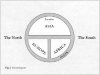 One the tasks of the historian is to reconstruct how people in earlier societies understood the world they lived in. Their understanding of the world determined the limits of their ambitions. Take ourselves as a starting point – artefacts which reflect our understanding of the world are everywhere. We all have some sort of world map in our heads. It is built up from maps we have seen – either in books or advertising; the globes that we have seen and spun; and, of course, we all have met people from every area of the globe and know that we can fly right around it. The most interesting artefact we have indicating our view of the world is even more expressive than a map. It is the photograph of the shimmering blue and white planet against the darkness of space, taken from a space-craft. This is to us far more than a photograph: it carries the tacit message that we can sum up our world in a glance, it is a tribute to our technology, and for different people it reinforces different beliefs. It can be used to support the belief that we now really understand the world around us or to support causes from greater political co-operation to ecology. It is used in religion books to suggest that the universe is somehow sacred, but it can equally be used to suggest the opposite: we are just a drop in the ocean of space.
If you lived in a society without maps, globes or that photograph – what would your image of the world be like? To such questions regarding historical societies we can give only guarded answers. We simply do not know how the ‘average person’ in Roman times, during the Middle Ages, or indeed until the end of the 18th century envisaged ‘the world’. However we can know with relative precision how people who deliberately examined the question, in other words geographer,thought of it. For those who had something more than rudimentary education we can make generalisations about what was the ‘common knowledge’ of the time. For those without education we can further extend the generalisation and add to it hints from songs, folklore and public works of art they might have seen such as those found in many medieval churches. So trying to piece together how any particular society – or at least its learned class saw the world is both a difficult and a worthwhile task.
 A FLAT EARTH ?
Before we can look for any medieval material we must identify our own prejudice. This is principally the belief that before Galileo, Copernicus, or Columbus, that people thought the world was flat. This little bit of feeling superior to those ignorant medievals is just over two centuries old, but has been assumed without question by so many historians that the opening footnote in academic articles on this topic is usually: ‘the sphericity of the earth was of course assumed during the period’. In brief, they believed that the universe was made up of four elements. The heaviest of these – earth – falls to the centre of the universe. This is the centrum mundi and everything else in the universe, Sun, Moon and stars revolve about this. (It is this belief that was shattered in the 16th century). On top of earth is the next heaviest element – water. Next comes air and on top of this, fire. This system seemed to be proven by observation: fire and air ‘go up’ and the others ‘fall’. Around our earth revolved the planets and the stars which were made either from a special kind of fire, a special mixture of all four elements or an otherwise unknown ‘Fifth Element'(the ‘quintessence’). Beyond that was God who made the whole thing and kept it running. On earth the four elements were never perfectly sorted out: so water was often under earth and had to burst up in streams and wells. Some earth was stuck up in the air as mountains. And even air and fire could be trapped, yet be so anxious to get to their ‘proper position’ that they burst up furiously in volcanoes. This geocentric system was never seriously questioned in the Middle Ages as it was part and parcel of religion, science, medicine, art and literature. There were several ‘demonstrations’ that the planets (Sun and Moon included) and the other elements revolved around earth (that is the element we are standing on) which incidentally showed that the earth was a sphere.
(l) The band of the stars (the Zodiac) could ‘descend’ at one point of the compass ‘below’ the horizon at an angle; while it ‘rose’ at the opposite point at the same angle. Hence it revolved around the earth, for us it means they believed the earth was round.
(2) The moon could be visible yet the sun not visible from earth (i.e. night-time) so they are revolving so that they are visible from each other but not from earth: the proof is that the earth’s shadow is seen on the moon.
(3) Ships disappeared below the horizon which meant that wherever water was, it kept as close to the centre of the earth as possible – which implies they held it was keeping close to earth which was in the form of a ‘globe’ (from ‘globus’ literally: a spherical lump).
The form is from the ‘Etymologiae’ but the gap between the continents is marked ‘Mare magnum sive Mediterraneum’ (or Great Sea)
THREE CONTINENTS
Strange as a geocentric world appears to us, even more strange are their views on the arrangement of land on the earth’s surface. For the establishment of those views for the early medieval period we can look to one author: Isidore, bishop of Seville in the early 7th century. He drew on the geographical ideas of the Roman encylopaedist Pliny (23-79 AD) who in his Naturalis historia had begun the section on geography thus:
The whole terrestrial orb is divided into three parts Europe, Asia and Africa. Starting in the west at the Straits of Gibralter, where the Atlantic Ocean bursts inland, on your right is Africa and on your left is Europe. Between these is Asia and its boundaries are rivers: the Don (Tanais) and the Nile (Nilus). (Bk 3,1,3)
This neat little system he then filled out with other details, but its clarity as an overall image insured that this division of the world into three continents would be remembered while the detail was passed over. This piece of learning was transmitted, with a few adjustments and confusions, to virtually every place there were books during the early Middle Ages as it was used twice by Isidore. First, in his great encyclopaedia the Etymologiae. This was his life’s work and was intended as nothing less than a repository, in orderly arrangement by subjects, of all human knoweledge. His section on geography began:
The earth is called an orb (orbis) as it has rotundity and is said to be like a wheel (rota) … Flowing all around the edges of the land is the Ocean. The land itself is divided into three: first Asia, then Europe, and third Africa. But the ancients [presumably Pliny] did not divide the parts equally. For Asia starts in the southern part of the world, takes in the eastern part and ends in the northern part. Europe takes in the north-western part and Africa the south-western portion of the earth. So it is evident that the earth is divided into two hemispheres, one has Africa and Europe, the other is Asia by itself. These two hemispheres are cut into parts by the Ocean which flows between them. So for this reason we say the world is divided into two parts: the East and the West: Asia being in one and Africa and Europe being in the other. (Bk 14,2,1-3)
He then went on to describe the boundaries of the continents exactly as Pliny had done, to say that Paradise was located in the East (an idea based on Gen 4,16), and to give details of regions, rivers, mountains and cities all of which fleshed out his basic scheme. However, the real fascination of this passage is how it still affects us today. Isidore in speaking of East and West was simply referring to the fact that the empire was divided between the Eastern Empire ruled from Constantinople and the Western centred on Rome (then without an emperor). The East (Asia) spoke Greek and seems very distant and different from the West for (at least officially) both Europe and Africa spoke Latin. But his imagery has remained. This is the earliest text I have come across in which the notion of ‘The West’ (as we use the phrase in politics) can be found. We still speak of ‘hemispheres’, ‘the West’, ‘the East’, ‘the Near East’, ‘the Far East’ – and Paradise is still full of exotic eastern promise. Isidore is the first writer with our eurocentrtic world view and he is still with us in our mental geography.
The other use of Pliny was equally important in diffusing the idea of thrtee continents for it was in a very short work called On the nature of things (De natura rerum) which became the basic ‘science’ book of the Middle Ages. There he wrote:
Now let us define the position of the lands and the seas which are interspersed between them. The land of the earth is gathered in a central place and around this place the stars revolve equally … and the Ocean flows around almost all the edges of the lands lapping their shores. … Now the region of land is divided into three: Asia, Europe and Africa. The sea divides Europe from Africa at the ends of the Ocean where the Pillars of Hercules [Gibralter] are. Asia is separated from Libya with Egypt [i.e. the Roman province of Africa] by the mouth of the Nile known as the Canopic. Asia is separated from Europe by the Don (Tanais) which breaks into two when it flows into the marsh (in paludem) called Maeotis [the Sea of Azov] Europe is in the North-west, Africa in the South-west and Asia runs from the South, takes in the East and ends in the North. So the world can be seen to be divided into two: Africa and Europe in one half, and Asia alone in the other. Now there is a division between Europe and Africa by the Ocean bursting in and making ‘our Great Sea’ [the Mediterranean] Now they [the ancient geographers] estimate the length of the land to be 80,000 stadia. (Ch 48).
Minimal information – No confusion
On these two somewhat conflicting descriptions, people in Europe for more than 500 years would base almost all of what they said about the sphere on which they lived. His confusion of somewhere on the equator with the pole would later be expanded (with evidence no less !) by Adomnan, abbot of Iona, who in his book on the Holy Land written in the 680’s would identify the centre of the lands with the city of Jerusalem (following an idea from the Bible). He believed the proof of this was that an upright column there would cast no shadow on June 21 which meant the Sun was directly overhead.
Two things Isidore did not mention in these passages were also ‘common knowledge’. The first was the question of whether there were people (‘the Antipodes’) and land for them to stand on on the other side of the sphere. It was a question that was often raised but by the time of Isidore it was considered merely useless speculation. Indeed, since the ocean could not be traversed, it also implied that there were people who would not hear the message of Christ and so the whole idea was frowned on by the Church. The other piece of ‘common knowledge’ was that the ratio of land to sea on the surface of the earth was 6 parts dry land to one part sea. This notion they got from 4 Esdras 6,42 – a book they took to be part of the Bible, though it is omitted from most Bibles today. The little touch of arithmatic (80,000 stadia) also deserves comment. With all such measurements attempts to say ‘what they mean today’ are useless – they are just idle numbers from a period before there were any accurate measuring instruments. The number itself is a corruption of a figure found in Aristotle (4th century BC). However, the curious notion of the 6:1 land-sea ratio and this figure for distance, together played a crucial role in convincing Columbus in the 1480’s that a trip west from Gibralter to the Far East was a definite possibility.
ENTER MAPS
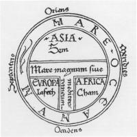
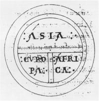
In order to make these descriptions clearer drawings were added. In the case of the De natura rerum the idea to do this was most probably Isidore’s own as the book had, almost from the start, the name ‘Liber rotarum’ (the book of the wheel drawings). They are the earliest representations of the earth in books or on parchment or paper that have survived – there are more than 1,000 in manuscripts before 1200 AD. These drawings we call ‘T-O Maps’ as they look like the letter ‘T’ inscribed in the letter ‘O’; but we should remember that they are not maps in our sense of the word. A modern map is an attempt to visually display with scale and detail what is the situation on the ground, these are better described as sketches to illustrate a literary description. As such, they are as much akin to schematic diagrams in modern textbooks as they are to maps in a geography book. Since Isidore’s information differed between his two works two different ‘T-O’ sketches are possible (see figs 1 and 2). However, during the Middle Ages this difference was not always obvious. An amalgam of the two images was produced which depending on the particular manuscript has features of one or other or both. Thus the drawing found in a manuscript of the Etymologiae may have the information from the De natura rerum and vice versa (see Fig.8). A drawing in a manuscript of the Etymologiae might be copied in a text of the De natura rerum, and vice versa, and then an extra bit added whether it fitted or not. For example, the bit of ocean between Africa and Asia (see fig.l) might have the name ‘Nilus’ added to it aswell (see fig. 3). On other occasions a copyist faced with the discrepancies between the texts tried to combine all the features producing even more confusion: such as thinking that the Don did not flow into a marsh (in paludem) called Maeotis, but that on one side was a place called ‘Paludes’ and on the other one called ‘Maeotis’ (see fig.4). Others avoided all that was not common and produced a very simple drawing with only the basic common elements identified (see figs 5 and 6).
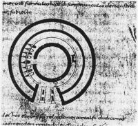
Diagram from Adomnan’s De locis sanctis’.
ENTER THE IRISH
Irish are involved in this story in two ways. First, they were among the earliest scholars outside Spain to use these works of Isidore. By the mid-7th century they were using them to solve problems they had in interpreting the scriptures. Perhaps the best example is Adomnan (died 704) when he wrote his great work to solve exegetical problems relating to the Holy Land (the De locis sanctis) he quoted bits from the De natura rerum. Moreover, it is clear from the way he arranged some of his material that he thought of the world in terms of three continents as on a ‘T-O Map’. His own work does not contain such a map but it has drawings which show signs of Isodore’s maps having been used as a model to produce diagrammatic representations – of buildings in this case which Adomnan had never seen! Three out of four of the buildings are drawn with a compass and ruler and as in the case of Isidore’s drawing he refers to them as ‘rotae’ (see fig.7).
Irish scholars in Europe noticed how Genesis 10 says that after the Flood the earth was divided between the three son of Noah: Shem, Ham, and Japheth (Sem, Cham and Jafet in Latin) and from these came all the peoples of the earth. They began to use ‘T-O Map’ in their studies of the Bible and hence the three names began to appear on the maps themselves (see figs 3,4 and 5). In later centuries this linking of biblical races (semitic and hamitic – I cannot think of anyone who referred to Europeans as ‘jafetic’) with the actual peoples in different parts of the world was to have a long and sorry history in racism.
The second way the Irish were involved was in the dissemination of these maps. Ireland was of great importance in spreading knowledge of Isidore through Europe. A large proportion of the oldest manuscripts of these works, as they are now found in continental libraries, show signs of contact with Ireland. An example is the manuscript from which fig. 8 is taken. Now in Paris (BN Lat 10616) it is one of the principal manuscripts of the De natura rerum and was written under Irish influence in Verona around 795 AD. It also has direct links with two other Irish centres – St Gallen (Switzerland) and Salzburg (Austria) where there was an important school under Virgilius (Feargal) (died ?784) concerned with geographical questions. It is found in the same manuscript as a commentary on Genesis that uses ideas from a ‘T-O Map’ to solve biblical problems. Thus, these diagrams not only show us how early Irish scholars conceived their world, but also what they taught. Indeed, it was an Irishman named Dicuil who working out of this milieu wrote in 825 his De mensura orbis terrarum (On the measurments of the lands of the earth) – one of the few geographical works of the period that broke new ground.
The T-O image is now quaint, but its power as an image to influence centuries of thought should not be underestimated. As an image it became the ‘orb’ held in the king’s hand, or depicted as in the hand of God. It clearly showed Europe as a distinct geographically and racially. And, since it never hinted at its own incompleteness but gave the impression that ‘we know all that is to be known’ no doubt it contributed to a static notion of learning where search or discovery would yeild little that was new.
Reading:
R. Baumgarten, ‘The Geographical Orientation of Ireland in Isidore and Orosius’ Peritia 3(1984)189-203.
J. Carey, ‘Ireland and the Antipodes: The Heterodoxy of Virgil of Salzburg’, Speculum 64(1989)1-10.
M. Destombes,Mappemondes: AD1200-1500 (Amsterdam 1964). P.D.A. Harvey, Medieval Maps (London 1991).
C.W. Jones, ‘The Flat Earth’, Thought 9(1934)296-307.
A.P. Newton, ‘The Conception of the World in the Middle Ages’, Travel and Travellers in the Middle Ages (London, 1926), 1-18.
T. O’Loughlin, ‘Knowing God and Knowing the Cosmos: Augustine’s Legacy of Tension’, Irish Philosophical Journal 6(1989)27-58.
-, ‘The Exegetical Purpose of Adomnan’s De Locis Sanctis’, Cambridge Medieval Celtic Studies (1993) forthcoming.
M. Smyth, ‘The Physical World in Seventh-Century Hiberno-latin Texts’, Peritia 5(1986)201-234.
W.S. Stevens, ‘The Figure of the Earth in Isidore’s “De natura rerum”‘, Isis 71(1980)268-277.
The author, Thomas O’Loughlin, is preparing an edition of two anonymous Irish commentaries on scripture from the 8th century; he teaches medieval history in the Milltown Institute.