Spéirview: history and heritage from above
Published in Issue 1 (January/February 2016), News, Volume 24By Darren Doyle
It’s a cool Saturday morning in October. It’s just before sunrise and the mist is sitting lightly on the hills. Most people are warm and snug in their beds. Not us, though. As I lift a compact flying machine out of my bag, I can’t help but think back to how the Wright brothers showed the world in 1903 that the impossible could become possible with heavier-than-air flight. A little over 100 years later and I’m standing in a field setting up a landing zone, walking through our checklists, checking and rechecking our equipment for flight. We’re drone pilots and we’re about to fly a remotely piloted aircraft system (RPAS) into the high blue yonder and see a part of Irish heritage like never before.
Growing up in Carlow surrounded by countless antiquities—from Duckett’s Grove or Ballymoon Castle to Europe’s largest dolmen at Brownshill—I’ve always had an appreciation for our heritage and history. One of the first things I wanted to do with our new RPAS was to head out to a historic site and fly around it to see what it looked like. The results were just exquisite. We were looking down from a perspective that people could never have envisioned when building these sites. We were hooked and Spéirview was born.
Weekend lie-ins were no more and early morning drives became the norm. We’d research a number of sites in a given area, then travel across the length and breadth of the country looking for Ireland’s hidden gems to get photos and videos. We’d write up a piece on the history of the location and then share everything we learned on Facebook or YouTube. We soon found that people love to learn more about their history and heritage. For example, we’d pass an unassuming ruin in a field and think it’s pretty cool. We’d stop, take some pictures and post them to our page on Facebook, not giving it another thought. A few hours later it had reached in excess of 30,000 people around the world.
It was incredible to see how people related to a place or had some emotional attachment to it. Many of the places we visited were the playgrounds of yesteryear’s children. People shared stories of family picnics or playing hide-and-go-seek in the ruins. People who left our shores ten, twenty or thirty years ago to make a new life in America or Australia sent us messages thanking us for bringing back fond memories of home for them. It’s reactions like this that drive us out each weekend to capture more and more pictures so we might reach out to someone and bring back a memory or story.
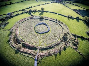
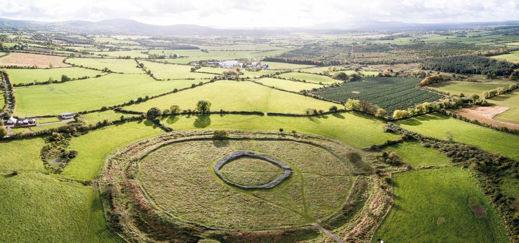
Our favorite shoot to date has been Rathgall Hillfort. A multivallate hillfort dating back to 800 BC, it sits on the edge of a ridge in County Wicklow. Rathgall covers eighteen acres, so it’s quite a magnificent structure, with far-reaching panoramic views from the ground. We were excited to see the view from the sky and what we shot was really striking. We could see the whole monument in a single view—the clearly defined inner wall, the second and third defensive ramparts. We were a tiny spec in the middle of the picture! It was really awe-inspiring to look at and think about the differences between their world and our own modern world.
Coming fresh to RPAS, there is a bit of a steep learning curve and you can expect to crash your RPAS many times at the start. Luckily, they are robust and replacement parts are mostly cheap, but it has made people rethink how to take videos and pictures. For archaeologists it’s a game-changer. In a little over an hour an RPAS pilot can survey a site and produce images and video or create a 3D model of the site. For more complex or in-depth study, an RPAS can be fitted with near-infrared and multispectral cameras.
Until the advent of RPAS, if you wanted quality aerial shots or infrared images of somewhere like Rathgall Hillfort, for example, you would need to hire a helicopter at incredible expense. Now you can find a qualified drone pilot (or become one yourself!) and for a fraction of the cost have an updated view of pictures, videos or 3D models created of a historic site ready for study in a matter of hours.
Spéirview Ireland is fully qualified and insured, holds an aerial works permit from the Irish Aviation Authority, and can be contacted at info@speirview.com or +353 (0)85 7474203. You can visit www.speirview.com for more pictures, videos and information.
Darren Doyle is the chief pilot and operator at Spéirview Ireland.