Old Ennisnag Bridge, Stonyford, Co. Kilkenny
Published in 18th–19th - Century History, Early Modern History (1500–1700), Features, Issue 2(March/April 2012), Volume 20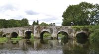
The upstream elevation indicates that the bridge is much older than the downstream face, the product of a c. eighteenth-century widening.
The old bridge at Ennisnag, crossing the King’s River outside Stonyford, is located approximately six miles south of Kilkenny and lies on the original road connecting Kilkenny to Waterford. The bridge was bypassed in 1827 when the ‘new’ Ennisnag Bridge, a three-arch ashlar structure, was built downstream.The downstream face shows a picturesque bridge that appears to date from the eighteenth century, but the upstream elevation indicates that the bridge is actually much older. At some point it was widened by 6ft: the original was just 12ft wide. The underside of one of the arches displays a break in the barrel in which the junction of the original structure and the later extension is clear. Also evident in the mortar are marks of wattles, used to cover the centring upon which the original arch was formed. Such wattle marks are often associated with vaulting in Irish castles constructed in the fifteenth and sixteenth centuries. There is evidence, however, that this construction technique dates back to the twelfth century or earlier.Establishing the age of many early bridges is problematic, and Ennisnag is no exception. The old bridge is shown on the Down Survey (1654–6) but the routes it served are not detailed. The bridge is also clearly indicated, and named, on Moll’s New map of Ireland (1714), which is the earliest map of Ireland’s road network. Rocque’s map of 1759 shows Ennisnag as a crossroads, where the route from Dublin southwards through Carlow, Leighlinbridge, Gowran, Bennettsbridge and then through Callan to Carrick-on-Suir or through Clonmel to Cork intersects the road between Kilkenny and Waterford. Taylor and Skinner’s Maps of the roads of Ireland (1778) shows the exact location of the bridge.Bridges may be dated by examining their construction details. The bridge at Ennisnag has a number of features that indicate that it may date from as early as the twelfth century. The narrowness of the bridge; the semicircular profile of the arches; the ratio of the widths of the piers to the spans; the triangular upstream cutwaters, one of which is extended to form a pedestrian refuge; the wattle marks; and the use of fieldstone to construct the arch barrels—when taken together, all indicate that the bridge dates from the twelfth to the sixteenth century. A strong clue that the bridge is very early, however, comes from the nature of the arch rings. An examination of the three central arches shows that the rings have not been ‘turned’, with the stones laid in a radial pattern. O’Keeffe and Simington in their Irish stone bridges (1991) identified this feature in bridges that date from the thirteenth century or earlier.
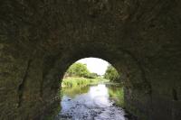
The underside of one of the arches displays a break in the barrel in which the junction of the original structure and the later extension is clear. (NIAH)
Finding written evidence of the existence of a bridge before the Down Survey is a matter of luck. In the case of Ennisnag, however, luck has provided such evidence. Revd Hugh de Rous, bishop of Ossory (fl. 1202–18), exchanged lands with William de Marshal, first earl of Pembroke (1147–1219), early during his term of office. The details of these land transfers are recorded in the bishop’s charter and the earl’s acknowledgement. Transcripts of both documents, which were originally recorded in the White Book of the Diocese of Ossory, were translated and published by Revd James Graves (1815–86) in the Journal of the Kilkenny Archaeological Society (1859). Both documents locate a parcel of land with reference to the bridge of Ennisnag. Of course, it is possible that the bridge mentioned in the document was replaced by the current structure. Nevertheless, the very early features make it equally possible that sections of the old bridge date from this period. This would place Ennisnag amongst the oldest bridges in Ireland. HI
Dermot O’Dwyer is an Associate Professor in the Department of Civil, Structural and Environmental Engineering, Trinity College, Dublin. Series based on the National Inventory of Architectural Heritage’s ‘building of the month’, www.buildingsofireland.ie.