Napoleon’s Irish legacy: the bogs commissioners, 1809–14
Published in 18th–19th - Century History, Features, Issue 5 (Sep/Oct 2005), Volume 13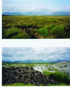
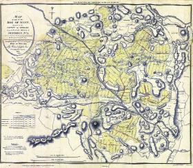
Bogland near Clifden, Connemara—one of the areas surveyed by Alexander Nimmo.
The year is 1808 and Napoleon’s dominance of Europe is at its zenith. The British government seeks desperately for alternative sources of vital raw materials, especially the flax and hemp crucial for making the sailcloth that propels the British navy. Without a functioning navy, there is no answer to Napoleon. As the year closes, the crisis deepens further. The position of the British expeditionary force in Spain, led by Sir John Moore, is growing desperate.
Such circumstances stimulate levels of creativity and expediency that would be smothered in duller, saner times. In the crisis of 1808–9 the authorities in London clutched at the straw that a supply of hemp and flax could be secured by draining the great soaking bogs of Ireland. Ideas in favour of extensive bogland drainage were being strongly advocated during 1807–8 by, among others, Thomas J. Rawson of Athy. Within a year these ideas rapidly attracted a wider interest in Britain, as well as in Ireland. Growing hemp on bogs had the great merit that it would not interfere with established tillage land, already under pressure to provide food for a growing nation.
Various government agencies now signalled their consent for an initiative on Ireland’s bogs. Support came in England from the admiralty and from the boards of agriculture, trade and the navy, in Ireland from the trustees of the linen manufacture, the lord lieutenant and the chief secretary, and, crucially, from the most consummate and influential Irish politician of the day, the former speaker of the Irish House of Commons and now the chancellor of the Irish exchequer, John Foster. A memorandum of January 1809—written in the shadow of the British withdrawal from Spain following the disaster at Corunna—expressed official thinking:
‘That Ireland can grow . . . without encroaching on the tillage of corn must be evident to any one who reflects on the uncommon quantity of undrained bog there and that no ground produces better flax than drained bog properly prepared . . . Considering therefore what a great object it must be to render the empire independent of foreign countries for the prime material of so extensive a manufacture and to reclaim thereby and bring under the plow so many additional acres of land is a subject of the utmost importance and demands the most immediate and serious attention.’
The commissioners
In the following months, an act was prepared to appoint commissioners to ‘enquire and examine into the nature and extent of the several bogs in Ireland, and the practicability of draining and cultivating them; and the best means of effecting the same’. Only a small amount of government money was being committed at this, the survey stage. The act provided for an initial support of £5,000 and for the commissioners to complete their task by August 1811. Nonetheless the appointment of the bogs commissioners involved hotly debated issues of power and patronage. To forestall criticism that the new body was an ‘Irish job’, the English chancellor, Spencer Perceval, suggested the speaker of the [British] House of Commons as a commissioner. However, when the nine commissioners were confirmed in September 1809, all were Irish-based. The chairman was the veteran military surveyor and antiquarian General Charles Vallancey, now in his eighties. Other members included two of Foster’s nephews, John Leslie Foster and John Staunton Rochfort.
The engineers
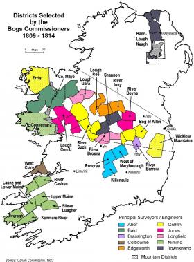 Given their seals of office on 15 September, the new commissioners established themselves at the premises of the Dublin Society and set about their work with remarkable speed. The immediate requirement was to establish the extent and nature of the bogs by making surveys. By the end of the month the key decisions had been taken. Ireland was divided into a series of districts, the instructions for the engineers who would survey each district had been compiled, and the first appointments had been made.
The two engineers first appointed could not have offered a greater contrast. Richard Griffith, recently appointed mining engineer to the Dublin Society and the son of one of the commissioners, had trained in Edinburgh. He was later to produce the first geological map of Ireland and to be the mastermind for the famous ‘Griffith valuation’ of land and property. For the bogs commissioners, Griffith first took on the great Bog of Allen, an area lying mainly in west Kildare and east King’s County (Offaly), extending to over 70,000 statute acres. Forty years older was the inventor and individualist Richard Lovell Edgeworth, who, though ailing and in his mid-sixties, now found himself taking on an extensive district in the hinterland of his home at Edgeworthstown, Co. Longford.
In the months following, engineers were appointed to take charge of several other districts east of the Shannon. They included two with a canals background, J.A. Jones of the Royal Canal, who looked after the Boyne district centred on south-west Meath, and the Englishman Thomas Townshend, who took on the River Inny district covering the western part of Westmeath. Also appointed were two land surveyors, the meticulous John Longfield, who took on the Brosna district covering large parts of the west of King’s County, and the cantankerous Richard Brassington, who became responsible for a small district in south-central County Kildare.
Further appointments proved more difficult because of a shortage of people with appropriate skills. The bogs commissioners operated at a time when the engineering profession was in its infancy yet when engineers were in demand, in both Ireland and Britain, for the infrastructure of the Industrial Revolution. The canal engineer John Killaly did not respond to an overture from the commissioners. Two engagements that were made—the Castlecomer-based David Aher in Tipperary and the young Scotsman William Bald (already working on his famous county map) in County Mayo—had to be on a part-time basis. Another appointment—canal and colliery engineer Thomas Colbourne to west Clare—was for a short, 141-day session.
The search for engineers eventually extended to Britain, with one far-reaching result. In June 1811 the Scotsman Alexander Nimmo made the career shift from schoolmaster to engineer, and came to Ireland to take charge of the south-west (mainly County Kerry) district. Over the next two decades, until his death in 1832, he was to make his mark, contributing to the modernisation of many parts of Ireland by building harbours, bridges and roads.
Instructions
The instructions provided by the commissioners specified the survey procedures and how the results were to be presented by each engineer. Only the larger bogs—those over 500 Irish acres—were to be levelled and mapped, with proposals being set out for the location of drains and for drainage in general. A written report and cost estimates were to accompany a district map. After being initially hand-drawn at the scale of four inches to the Irish mile (1:20,160), the latter were usually to be printed at the reduced scale of two inches to the Irish mile. Vertical sections showing slices of the bog and indicating the nature of the understrata were also to be prepared.
Each map was to show considerable detail. Besides the extent and boundaries of the bogs, features of the existing drainage were to appear, and an indication was to be given of the nature of the bog surface (whether firm black bog or ‘shaking quagmire’) and of the ‘soil and country’ adjoining the bog, specifying the situations of limestone, limestone gravel marl and other manures. A further instruction (no. 28) specified that the engineer was to ‘lay down all remarkable objects . . . likely to be permanent, such as raths, castles, towers, cairns, hill tops, market houses & c’.
Such detail was to be taken as part of the commissioners’ long-term ambition (perhaps one inspired by Vallancey) to connect and effectively unify the individual surveys. With this in mind it was also hoped to correlate the various measured levels to a Dublin base (initially the foot of the new Nelson’s Pillar, later the high-water level of an ordinary spring tide at the Pigeon House dock). Though prudently never fully articulated, there must have been the hope that the bogs surveys might exceed the immediate agenda to become the stepping-stones to some sort of national survey.
Remuneration
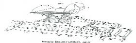
Portable railing and carriage invented by Richard Lovell Edgeworth, who surveyed the hinterland of his house in Edgeworthstown, Co. Longford.
The ten engineers held their posts directly from the commissioners. They were paid at the rate of two guineas a day plus a guinea a day expenses. All others were recruited by individual engineers. Nonetheless, the commissioners fixed the pay rates offered to the major categories of employee in the mainly seasonal workforce. The surveyors received a guinea a day and had considerable responsibility, leading field parties of five or six staff men, chain-men and labourers, all of whom were paid at daily rates of between 1s 8d and 3s 3d (Irish money). Around 50 surveyors were engaged on the bogs surveys over a four-year period. Some worked for quite short spells. Others, like John Molloy and Richard Buck, who respectively worked 1,128 and 989 days for Richard Griffith, stayed for long periods and moved districts with their employer.
Progress of the surveys
From the outset Richard Griffith set a fast pace. He started his survey at a canal bridge near Robertstown, Co. Kildare, on 9 October 1809, less than three weeks after the commissioners had held their first meeting. Over the next four years he was to claim for working 1,300 days on the bogs surveys, including many seven-day working weeks. With the aid of base maps drawn from Alexander Taylor’s 1783 survey of County Kildare and using mapwork for King’s County, which the commissioners bought from William Larkin, Griffith and his teams worked throughout the mild winter of 1809–10. By late spring he had completed and reported on the County Kildare portion of the Bog of Allen. Accompanied by a map, sections and detailed estimates of the drainage costs, his work formed the centrepiece of the commissioners’ first report to parliament in June 1810.
The progress of other surveys was less rapid. Richard Lovell Edgeworth in Longford was characteristically challenged more by scientific and technical issues than by the preparation of a development blueprint. His report, completed in autumn 1810, includes comments on the origins and preservative properties of bogs and a description of a bog-burst close to the River Camlin. Appendices include accounts of various ‘machines’, among them a carriage that might run on wooden moveable railways laid across the bogs. There is also a detailed account of the survey and triangulation procedures used in compiling the district maps—work mainly done by Richard’s son, William, who published a map of County Longford in 1814. A final appendix lists the depth of bog and height data recorded at some 700 locations in the district. Such detail contrasts with Edgeworth’s very generalised remarks on development and drainage issues, and their likely cost.
Five district reports and maps covering extensive areas east of the Shannon were included in the commissioners’ second parliamentary report in spring 1811. About the same time, parliament extended the life of the commissioners to January 1813 and provided a further grant of £12,000. Some engineers had already been redeployed west of the Shannon, but this grant now secured an extension of the commissioners’ work. William Bald was already working across much of Mayo. Richard Griffith now moved to the difficult River Suck district. J.A. Jones took on the Corrib district of east Galway, John Longfield moved into north Roscommon and Richard Edgeworth extended his work into the upper Shannon.
Outside of this extensive, near-contiguous group of districts, Thomas Townshend moved north to explore the lowland bogs bordering Lough Neagh, the River Main and the lower Bann. His district, focused mainly on west Antrim, was the only part of Ulster included in the bogs surveys. In the south, with the arrival of Alexander Nimmo, the survey of the Kerry bogs commenced. Within six months of his arrival Nimmo had completed his map of the barony of Iveragh, one of the great maps of pre-Ordnance Survey Ireland.
The main attention of the commissioners was to the deep raised bogs of lowland Ireland. But in another 1811 initiative the commissioners embarked on a series of shorter, less-intensive surveys of the blanket bog districts that are widespread in upland areas and in parts of the west. Richard Griffith left his teams on the River Suck to spend two months reporting on north-west Mayo, and in May and June 1812 he made a rapid survey of the bogs in the Dublin and Wicklow mountains. Alexander Nimmo, when he had completed his Kerry work, was transferred to explore the extensive, rock-strewn blanket bogs of lowland Connemara.
Nimmo’s 24-page report on Connemara provides unique insights. Here are estimates of the population (about 30,000, nine-tenths living along the coast), comments on the climate and cattle (they are never housed, the breed are not such good milkers as in Kerry), and descriptions of the soils and geology. Fishing, seaweed-gathering, kelp-making, the burning of lime, and trade between the mainland and the Aran Islands all have their place in an account that also includes proposals for new village and road developments. This is an acutely observed description that, as with Kerry, ranges far beyond the bogs. It deserves to be better known.
The map to go with this Connemara report was never completed. It was overtaken by the enforced wind-down of the bogs commission. By 1812 support for their work was lessening. A year earlier, the influential John Foster had resigned as Irish chancellor. Now Vallancey was ailing and John Leslie Foster was no longer an MP. A further grant and a one-year extension, to allow the commissioners’ work to run on to January 1814, was the last parliamentary support, and plans to extend the work into the north-west never matured. From summer 1812 their efforts focused on the completion of the reports and (with the exception of Connemara) maps for the districts where work was already under way.
Richard Griffith’s map of the Bog of Allen.
The commissioners’ third and fourth reports to parliament—their final published work—appeared in April 1814. Their ten engineers had by then compiled, in the commissioners’ words, ‘the most accurate surveys which have ever been made, of a very large portion of this island’. Over one million statute acres had been ‘minutely surveyed and levelled’. Several hundred thousand acres of mountain land had been assessed in less detail. From this extensive fieldwork the commissioners now estimated, surely with an unprecedented authority, that the extent of ‘peat soil’ in Ireland exceeded 2.83 million statute acres (about 13 per cent of the total land area). Of this about 55 per cent was ‘flat red bog’, with the rest mountain soil.
Before winding up, the commissioners made one final decision of long-term significance: the manuscript versions of the engineers’ reports, together with the relevant manuscript maps, would be handed over to the commissioners’ hosts, the Dublin Society, for safe-keeping. As a result many of these records survive, now reposing in the National Library of Ireland, the body that took over much of the Society’s library in 1877.
Conclusions
By 1814 the circumstances that had led to the establishment of the bogs commissioners had changed greatly. The shadow of Napoleon had receded. It had become clear that the drainage and cultivation of the bogs of Ireland would be a much slower and more expensive process than the authorities had wished to imagine in the crisis months of 1808–9. Moreover, as the commissioners indicated in their concluding reflections, any large-scale bog development faced resistance because of uncertainties about land ownership, and also because of widespread suspicions that any development would impact adversely on the traditional usage for fuel. Official enthusiasm had now waned, and it would be more than a century before a more interventionist government in an independent Ireland took the plunge and established Bord na Móna as the semi-state body to promote bog development on a large scale.
The legacy of the bogs commissioners of 1809–14 lies not in the limited immediate application of their work but in the four reports and some 50 printed maps that were produced under their aegis. These documents, particularly the maps, are significant for two reasons. First, the maps foreshadowed the value of, as well as the challenge presented by, a countrywide survey, a challenge that was taken up a decade later with the establishment of the much more comprehensively resourced Ordnance Survey. In the words of J.H. Andrews, ‘the bogs survey did more than anything else to change the face of cartography in early nineteenth-century Ireland’.
Second, the bogs reports provide exceptional insights into early nineteenth-century Ireland, as it was a generation before the Ordnance Survey made its large-scale maps and over 30 years before the Great Famine produced an irrevocable transformation. Recorded here are outline town plans, the clustered villages of east Galway, some 70 mills in pre-industrial Ulster, the locations of early Catholic chapels across parts of the midlands, and the road network of Iveragh before the building of the modern ‘ring-road’. Many of the maps, most notably William Bald’s meticulously detailed surveys of Mayo, provide a unique record of place-names that may amplify or act as an alternative to the later Ordnance Survey versions.
Perhaps because much of it either remains in manuscript or lies buried among the musty tomes of the British parliamentary papers, the work of the bogs commissioners, although widely known in a general way, has attracted relatively little sustained attention from academics. Likewise, its potential has been largely neglected by local historians. It surely deserves more intensive scrutiny.
Arnold Horner lectures in geography at University College Dublin.
Further reading:
J.H. Andrews, A paper landscape: the Ordnance Survey in nineteenth-century Ireland (Oxford, 1975).
J. Feehan and G. O’Donovan, The bogs of Ireland (Dublin, 1996).
G.L. Herries Davies, Sheets of many colours: the mapping of Ireland’s rocks 1750–1890 (Dublin, 1983).
G.L. Herries Davies and R. Charles Mollan (eds), Richard Griffith 1784–1878 (Dublin, 1980).
Three of the bogs commissioners’ printed maps—Iveragh in 1811, Kenmare River in 1812 (both by Alexander Nimmo) and Wicklow & Dublin Mountains in 1812 (by Richard Griffith)—together with major sections of the relevant district reports have recently been republished by Glen Maps.
The compilation of this article was facilitated by a President’s Research Fellowship from University College Dublin and a small projects grant from the Irish Historical and Social Sciences Research Council.