The development of the Limerick Main Drainage Scheme and Lower Shannon Navigation has necessitated large-scale archaeological investigations in the heart of Limerick city and in its rural hinterland from July 1999 to the present date. The scale and location of the construction work required a planned and innovative approach to the excavations, including a detailed pre-development archaeological study of the city and environs. It was necessary to develop techniques of excavation in semi-dry sections of the riverbed and to coordinate the programming of the archaeological and construction operations. The excavations also involved specialist archaeobotanical studies where suitable deposits were identified in association with archaeological strata, such as at Broad Street in the centre of the city.
The historic city
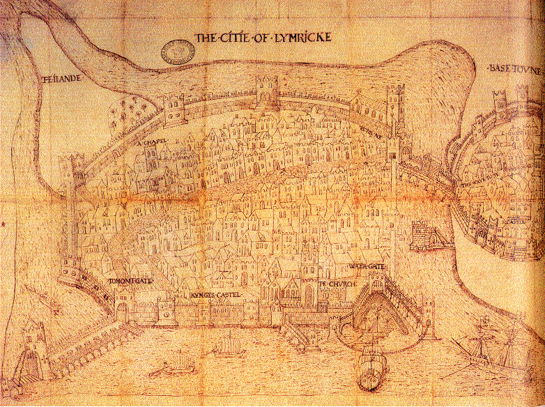
Limerick has played a central role in the ebb and flow of Irish history since its establishment as a town by the Vikings on King’s Island over a thousand years ago. Its status as a major administrative centre in the medieval period is reflected in the construction of St Mary’s Cathedral, King John’s Castle and the city walls, and has continued to the present day. It is not surprising, therefore, that before construction work began on the Limerick Main Drainage Scheme the potential for the discovery of new archaeological structures and artefacts was highlighted as an issue that had to be addressed as part of the design of the new environmental waste-water treatment system by Limerick City Council.
It was not possible to predict precisely what lay submerged below the waters of the Abbey River, nor what new sites would be identified around Limerick’s rural margins. As the considerable engineering work progressed, the river began to yield up its stories from the past. The discoveries that have been made as a result of the construction work reflect the civic history of the city, in terms of trade, commerce, wars and everyday life. The number and variety of the finds are a unique reflection of the city’s wide and varied history. The archaeological excavations were concentrated along the Abbey River to its confluence with the Shannon, and on George’s Quay and Charlotte’s Quay. Important new sites were discovered at Athlunkard to the north of the city.
Limerick before the Vikings
The early Irish genealogies tell of a place called Inis Sibtonn or Luimneach, an island in the Shannon. The recovery of worked flint from the riverbed points to settlement on the banks of the Shannon in the Neolithic period (5000–3000 BC).
Other artefacts found in the river include a spiral-headed pin (dating from c. AD 600–800) on the site of the ford at Baal’s Bridge, demonstrating the importance of this strategic location as a route before the arrival of the Vikings.
New earthworks were identified on the banks of the River Shannon at Fairyhill, just north of Limerick city. The earthworks, which are just below the tidal limit of the river, are silted and eroded. However, a detailed topographic survey revealed ‘D’-shaped defensive banks and ditches enclosing a low mound. The site is adjacent to St Thomas’s Island at a ford leading to the city via Athlunkard Street—hence the local placename Athlunkard (‘ford of the ship fort’).
The Vikings: from raiding to trading
The Vikings began raiding along the Shannon in the ninth century. The historical records suggest that a Dane named Yorus established a raiding fort at Limerick in 861. To date, the location of this early longphort has not been established. It may have been upstream of the city, adjacent to St Thomas’s Island, at Athlunkard; other scholars have suggested that it may have been on the site of St Mary’s Cathedral on King’s Island. Little is known about longphorts in Ireland, and the site at Fairyhill may be associated with the powerful O’Briens, centred at Kincora to the north.
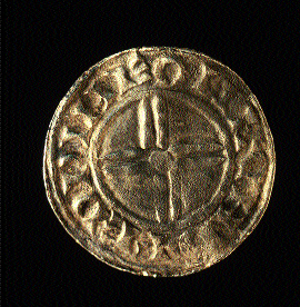
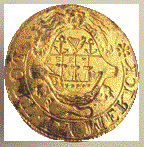
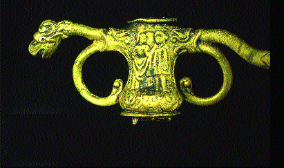
The Vikings established the first trading towns in Ireland. The Limerick Vikings established their town on King’s Island by the tenth century. The Vikings were craftsmen and traders, and it is this picture, as opposed to their traditional characterisation as plunderers, that emerged from the murky depths of the Abbey River. A silver penny minted for King Cnut, dating from AD 1035, is illustrative of trade and exchange between Limerick and London, where the coin was minted almost a thousand years ago by King Cnut’s moneyer, Edwine. A Viking strap end and zoomorphic mount dating from the early eleventh century are demonstrable examples of the fine metalworking technology of the time. The Viking artefacts are the earliest dated objects found in the Abbey River on the Limerick Main Drainage Scheme.
The new Anglo-Norman town and bridge
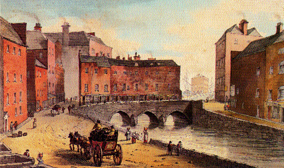
When the Anglo-Normans launched their assault on Limerick in 1175, there was no bridge in the location later occupied by Baal’s Bridge. Giraldus Cambrensis, the Cambro-Norman chronicler, suggests that the attackers found a ford across the Abbey River, as an Anglo-Norman ‘hurled himself headlong into the swiftly flowing river’ and managed to cross to the opposite bank. The capture of the city by the Anglo-Normans heralded the expulsion of the Irish and Vikings and the establishment of the ‘Irishtown’, as it then became known, on the southern bank of the Abbey River. Excavations at Broad Street uncovered two medieval bridge piers under the junction of Broad Street and Charlotte’s Quay. These structures formed part of the medieval bridge, built in the early thirteenth century (on the site of the present Baal’s Bridge), that formed the vital link between the Irishtown and the Englishtown on King’s Island.
The excavations at Broad Street indicated a long and deep (4.5m) archaeological sequence below the street level, commencing in the early thirteenth century and continuing up to the present day. Three samples from oak timbers that revetted one of the bridge piers were dated to the early thirteenth century. Organic deposits were identified abutting the bridge piers, and subsequent scientific analysis demonstrated that they had accumulated slowly during the thirteenth and fourteenth centuries as a result of the dumping of organic refuse and the accumulation of river silts. The excavation cast light on the growth and development of Broad Street, with evidence for house floors dating from the fourteenth/early fifteenth century built on top of ground reclaimed from the riverbed. This expansion of the Irishtown towards the Abbey River is likely to have been associated with renewed town wall-building, extending into the river. The uppermost archaeological deposits in the cutting consisted of post-medieval cobbling, drains and culverts.
The town wall along George’s Quay
Excavations along George’s Quay uncovered two principal sections of the town wall to a depth of 5m below the existing quay. The first section uncovered was at the junction of the medieval bridge, the town wall and a defensive tower defending the northern end of the bridge on the town wall.
The springing arch of the medieval bridge was identified at the easternmost external end of the town wall. A walkway or ‘sconce’ was identified, behind and inside the town wall, leading to an arched entrance into the tower. No surface trace of the structures was visible before excavation. The historical sources suggest that the medieval defences survived up to 1760, when the present quay was constructed; the medieval bridge was replaced in 1830. No medieval archaeological layers were recorded adjacent to the walls. The layers that abutted the structures were deposited as a result of eighteenth-century quay construction and nineteenth-century bridge-building. An excavation carried out on George’s Quay at the bottom of Creagh Lane revealed a similar sequence of eighteenth-century reclamation over and around the old town wall. However, a corner section of a mural tower or bastion on the town wall was identified along the length of the cutting.
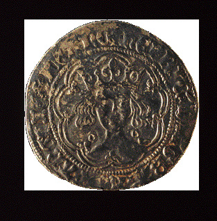
The archaeological excavations in the riverbed resulted in the collection of a large range of medieval and post-medieval artefacts that illustrate the commercial and vernacular history of the city. The finds date from all periods of Limerick’s past and include beads, coins (largely Irish, but also Scottish, English and French, such as a Henry VI silver groat (1422–7) minted in Calais), horse equipment, pins, brooches, tools, pottery and clay pipes. An early post-medieval (c. 1600) seal bearing the unique ‘Lymerick Port’ coat of arms was also recovered from the riverbed, as was a wedding ring hallmarked by the Limerick goldsmith William Ward, inscribed with two sets of initials (‘TM’ and ‘NH’) and the date ‘Feb 12th 1798’. The discovery of the ring in the riverbed raises questions as to how it was lost—accidentally, or in anger?
Animal bone and antler
A large quantity of food waste (cattle, sheep and pig bones) was recovered from the Abbey River. There was very little evidence that food was taken from the wild. It seems clear that sufficient meat was available from domesticated farm animals to supply the needs of the townspeople. However, occasional bones of red and fallow deer and small quantities of rabbit bone were found. The Anglo-Normans introduced fallow deer into Ireland for the sport of hunting. Goats were rarely eaten in Ireland, and the overwhelming evidence suggests that they were kept in Limerick to supply horn. Deer antler was also an important raw material in the production of combs, knife handles and other implements. A few adult dog and cat bones were found scattered in the riverbed. There were no complete skeletons, which is somewhat surprising, as the river would have been an ideal repository for dead animals.
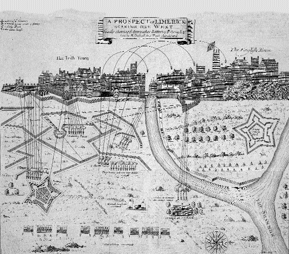
The siege of 1690
The legendary Siege of Limerick in 1690 followed William of Orange’s victory at the Boyne. William encamped outside the city in the late summer of 1690 and began to bombard it with cannon and mortar fire from Garryowen.
The bombardment concentrated on the city wall from St John’s Hospital to Baal’s Bridge, prior to the assault on the town walls and the infamously bloody ‘battle of the breach’. William particularly targeted Baal’s Bridge to destroy the link between the Irishtown and the Englishtown in order to prevent the Jacobites from reinforcing his point of attack from either side of the city. Williamite mortar fire rained down on the buildings throughout the city, causing much destruction and despair before his strike on the town walls. The 1690 siege is one of the few engagements in the war in which the Jacobites were victorious.
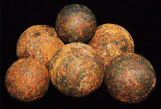
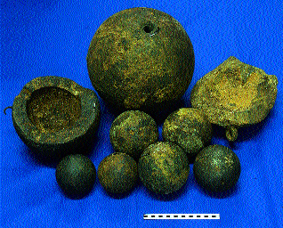
The excavations recovered a large assemblage of artefacts dating from the siege, including the iron and stone cannon balls, lead musket and pistol balls and large mortar bombs that William unleashed on the city. Other artefacts recovered include a fragmentary musket, a highly decorated officer’s sword hilt, gunflint, grenades and Jacobite gun money.
In the eighteenth century a phase of canalisation of the Abbey River included the attempted construction of a lock gate at its junction with the Shannon. This was the first attempt by Georgian engineers to control the waters of the Abbey River with the installation of a navigation scheme. The foundations were laid but never finished and were rediscovered with the dewatering of this location. Today’s navigation scheme sees the successful completion of the engineering scheme first contemplated in the late eighteenth century.
Conflict in the twentieth century
Many of the citizens of Limerick fought and died in the First World War. The commemorative plaque found under Matthew Bridge dedicated to Thomas Gleeson bears witness to one such individual.
Limerick was the scene of significant engagement between pro- and anti-Treaty forces during the Civil War in 1922. Although this is recent history in comparison to the arrival of the Vikings, the events of that year too have left their mark in the archaeological record of the Abbey River. Several Webley revolvers, bullets, hand grenades and shells were recovered. It would appear that, as the anti-Treaty forces retreated, they threw their guns and ammunition in the river to avoid arrest and detention.
Finding and minding
Study of the artefacts found on the Limerick Main Drainage Scheme builds up a picture of life in the past—diet, personal ornament, trade, commerce and conflict. The aim of archaeological conservation is to reveal the true nature of an artefact and to preserve it intact for as long as possible.
Artefacts found on archaeological excavations require treatment to preserve them and to investigate their original state. The standard method of recording artefacts is through description, photography and illustration. All of the artefacts found on the Limerick Main Drainage Scheme have been studied in this manner and have been dated by form, decorative detail and comparison with other artefacts.
The Abbey and Shannon rivers are dominant features of Limerick and are the focus for many of its most important buildings and cityscapes. These rivers have produced a substantial and remarkable collection that now totals more than 10,000 artefacts. The collection reflects the city in which they were discovered, in terms of both its long history of habitation and the events that shaped and marked the passing of time. The rivers have acted as a unique time-capsule, allowing us to visualise the city’s remarkable past.
Edmond O’Donovan is an archaeologist with Margaret Gowen & Co. who directed the excavations conducted for the Limerick Main Drainage Scheme and Lower Shannon Navigation.
Further reading:
J. Hill, The building of Limerick (Cork, 1997).
M. Lenihan, Limerick: its history and antiquities (Dublin, 1866).
E.P. Kelly and E. O’Donovan, ‘A Viking longphort near Athlunkard, Co. Clare’, Archaeology Ireland 46 (Winter 1998), 13–16.
S. Spellissy, The history of Limerick City (Limerick, 1998).