In the footsteps of a king
Published in Features, Issue 1 (January/February 2016), Medieval History (pre-1500), Volume 24TRACING THE ROUTE TAKEN BY RICHARD II DURING HIS CAMPAIGN AGAINST ART MAC MURROUGH IN 1394
By Samuel Kinirons
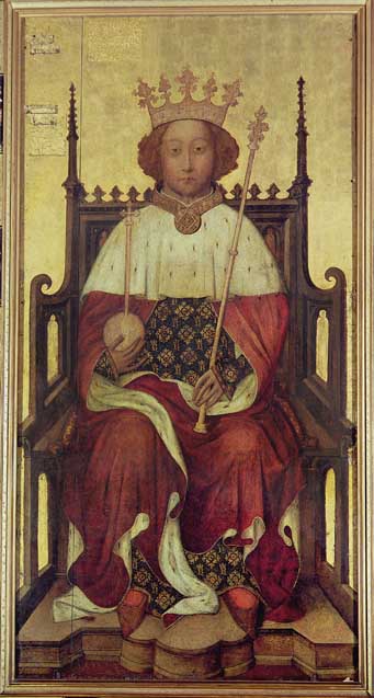
King Richard II c. 1395, just after his return from the first expedition to Ireland. (Bridgeman Library)
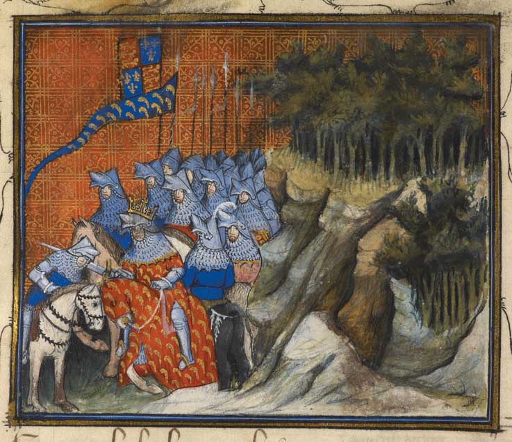
King Richard II (1377–99) was the first English monarch to set foot in Ireland since King John. Indeed, Richard visited Ireland twice, first in 1394–5 and again in 1399, shortly before the usurpation of his crown by Henry of Lancaster. On both occasions Richard came at the head of a large army in order to reassert his authority within the lordship of Ireland. The greatest threat to this authority in 1394 and 1399 arguably came in the form of Art Mac Murrough (Mac Murchadha), king of Leinster (d. 1416/17).
Curtis and the letters of Richard II
In the 1920s, Professor Edmund Curtis discovered seven transcribed letters bearing details of Richard’s Irish expeditions in the library of All Souls’ College, Oxford. These were located within a formulary book (MS 182). A formulary book was used to provide scribes with models for their own writings. As such these are just copies, though Curtis estimated that they were written in the reign of Henry IV (1399–1413) and have near-contemporary value. Curtis performed a great service in editing the letters and providing summary translations. He also sought to link the array of misspellings and abbreviations to known people and places.
Since then, snippets of these letters have often been quoted, in particular that relating to the dramatic near-capture of Mac Murrough at a place named ‘Laveroc’. Here the earl marshal almost caught ‘the said Mac Murrough and his wife in their beds. But they [were] told of the affray [and] escaped with great difficulty and at such short warning that they were very nearly taken.’ The value of the first three letters as a source for following the course of the military campaign in 1394, and in turn determining the location of Laveroc, has not, however, been fully appreciated. The first two are written by Richard II to Thomas Arundel, archbishop of York and chancellor of England. The author of the third remains a mystery, though it is clear that he was part of Richard’s army.
Curtis attempted to use these letters to trace the route taken by the king through lower Leinster. In the intervening 80-odd years, our historical and archaeological knowledge of this area has greatly expanded, although there has been no significant reappraisal of Curtis’s suggested route. With the wealth of new knowledge it is now possible to recreate a more complete and plaus-ible course taken by Richard II.
Attempting to track a medieval army is a frustrating but ultimately rewarding venture. Armies do not blunder blindly onwards; instead they strike at the vital organs of their opponent. Consequently, there is much that can be learned about the topographical and political framework of Mac Murrough’s territory by following the route taken by the invading force.
Richard II arrives at Waterford
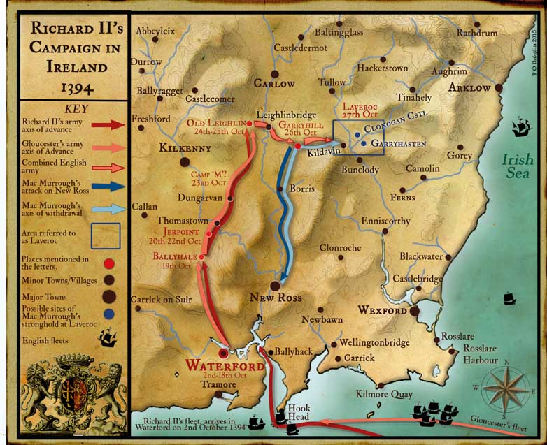
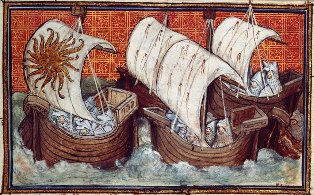
In his first letter the king states that, after ‘only a day and a night at sea’, he arrived at the city of Waterford on 2 October 1394. The army that accompanied him seems to have been very large by Irish standards. James Lydon, having considered the wardrobe accounts, the retinues of the various noblemen, the number of ships used to convey the troops and the soldiers that could be expected to be levied within Ireland itself, estimated a force of 8,000–10,000 men.
Richard remained in Waterford until 19 October. The king undoubtedly wished to receive homage from his loyal subjects from the surrounding area, as well as to lay down plans for the coming campaign. The main reason for this delay, however, was probably the fact that his uncle, the duke of Gloucester, had yet to arrive in Ireland. After two weeks the king decided to press on without Gloucester. This may have been in response to an attack by Mac Murrough on New Ross. The Annals of the Four Masters state that ‘an army was led by Art Mac Murrough, King of Leinster, against the English; and he burned Ros-mic-Triuin’. It seems likely that this was a pre-emptive assault by Mac Murrough while Richard waited in Waterford.
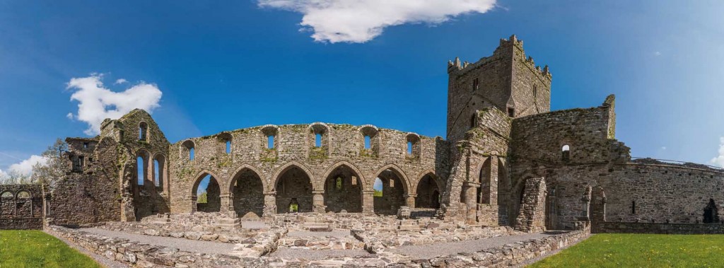
Richard II’s army crossed the River Suir on 19 October and ‘lodged that night in the fields, at a place called B’. The scribe who produced Curtis’s copies often abbreviated the names of places, providing only the initial letter. Curtis attempted to locate these by examining old variant spellings of place-names. In this case, Curtis suggested that ‘B’ denotes modern Ballyhale. The location where the army pitched camp the following night is given the unabbreviated place-name of Jerpoint, where the impressive ruins of a medieval abbey still stand. It is quite probable that the king himself was lodged within the abbey. Here again Richard’s army tarried. News had reached the king that Gloucester had finally landed in Waterford, ‘for which reason we stayed there on Wednesday and Thursday, awaiting the arrival of our said uncle’. After waiting two days, Richard decided to push onwards once more, again leaving the dilatory duke of Gloucester to catch up.
The location of the army’s camp on the night of 23 October is given as ‘M’, which remains unidentified. For the night of 24 October the location is given in full as ‘Leglin’. Curtis makes the convin-cing argument that this is Old Leighlin. Clearly Richard II made his way north by the low, even ground to the west of the River Barrow. This would have made marching easier and would also have kept him out of Mac Murrough’s heartland. Rather than having to fight his way north, he could advance swiftly and then attack from an unexpected angle. It is at ‘Leglin’ that Gloucester finally joined his nephew, the king. The army remained here for another day before launching its offensive in earnest.
A swift and relentless attack
The king wrote that ‘on Monday very early we thought to encamp in the said wood of G, which is, as we said before, the chief fortress that our enemy has’. The location of ‘G’ is probably modern-day Garryhill, Co. Carlow (Garbh Coill). Subsequent generations of a senior branch of the Mac Murroughs had their seat at Garryhill. Garryhill is not, however, very close to Old Leighlin (14km), and the fact that they arrived ‘very early’ suggests that the English stole a march, probably by setting off in the middle of the night in order to arrive long before the enemy expected them. Richard recorded that before the day was out Mac Murrough was ‘dislodged, and his principal house was burnt in our presence’.
Curtis was aware that there is a castle known as Rathnagarry a mile and a half from Garryhill. It appears to be a Gaelic castle and was built in the fourteenth or early fifteenth century. Curtis was, however, unaware of a local tradition that attests to the existence of an earlier castle at Garryhill itself. More recently, archaeologists have claimed that the shape of the gardens at Garryhill House suggests the existence of a possible bawn. Perhaps this was the Mac Murrough stronghold destroyed by Richard’s army on 26 October and Rathnagarry is its replacement? The suggested date of its construction means that it falls neatly into the correct time-frame.
The king recounted how on the following day ‘we lodged near and in front of another wood, called Laveroc, which is a particular refuge for our said enemy’. It was here, according to the third letter, that Mac Murrough and his wife dramatically evaded capture. Again it seems that the king’s forces had moved rapidly and had taken Mac Murrough by surprise. All that was left to the earl marshal after Mac Murrough’s flight were ‘certain art-icles of feminine use of no great value’ and ‘the seal of the said Mac Murrough’, which proclaimed his kingly status. The earl marshal ‘had his house burned’ and dealt out the same fate to ‘some fourteen villages’ in the surrounding area. The offensive of the English army seems to have been relentless, giving Mac Murrough no time to do anything other than flee.
The location of Laveroc
In attempting to trace the army’s progress to Laveroc, Curtis made a wrong turn. He believed that it lay south of Garryhill and was somewhere on the Barrow. He located Laveroc in a later source, which states that Elizabeth I acquired ‘Leveroke and also … sixteen towns standing on the Barrow’. While these sixteen towns definitely did stand on the Barrow, there is no suggestion that Leveroke did as well. Two other Elizabethan sources define much more clearly the location of Laveroc. They concern the acquisition and granting of land confiscated from ‘Leverocke’. In this case Leverocke seems to be the individual at the head of a sept rather than a geographical location. What is particularly exciting is that they both list the townlands that form the land taken from Leverocke. While Leverocke cannot be linked to a modern place-name, these late sixteenth-century townlands can be. They form a relatively dense cluster around modern-day Kildavin parish on the border of Carlow and Wexford, lying to the east, not to the south, of Garryhill. This location fits perfectly with the general direction of Richard II’s push from Old Leighlin to Garryhill.
Kenneth Nicholls’s immense genealogical work on the descendants of Art Mac Murrough has already confirmed that the Kavanaghs of Leverocke had their seat in Kildavin parish. Until now, however, the implications of this for plotting the course taken by Richard II in his campaign against Mac Murrough have been overlooked. It is now possible to right Curtis’s error and set Richard’s army back on its proper path. It is even plausible that archaeologists could pinpoint the exact location of Mac Murrough’s dwelling, now that we know where to look. It is almost beyond doubt that Laveroc stood at the northern end of the Blackstairs Mountains, on the high ground above the cleft where the River Slaney and the River Derry join.
Two potential candidates have caught my attention. One is a castle in the townland of Clonogan whose present remains consist of little more than two banks with intervening fosse. A valuation of the manor in 1540 records it as already ruinous. The second is a moated site in the townland of Garryhasten. Ploughing very near the site has uncovered evidence of fire in the form of blackened clay and cracked stone. Given the fact that we know that Laveroc was burned down, this site is very promising. Even if it is not Laveroc itself, it could easily be one of the fourteen villages that the earl marshal had burned after Mac Murrough’s escape. In order to locate Laveroc definitively an in-depth archaeological survey of the area would have to be conducted, and perhaps even excavation of some of the potential sites.
Mac Murrough comes ‘to surrender and submit’
King Richard II’s second letter states that on the day after the burning of Laveroc Mac Murrough ‘came humbly to obey us and to surrender and submit’. Mac Murrough surrendered on 28 October, less than three days after Richard had crossed the Barrow. Richard had swept into Mac Murrough’s lands with an army larger than had ever been seen in Ireland. The English had moved rapidly and had captured two of his chief strongholds in as many days. It is understandable, therefore, that he felt that the only option left was to place himself at Richard’s ‘mercy, without any conditions’.
The letters continue to track the campaign beyond this point, but it becomes increasingly difficult to follow. The army split up, and different elements of it began to operate independently over an increasingly large geographical area. The references to places now become ever more vague and sporadic. We are indeed fortunate that we can even piece together the first and arguably most critical month of the campaign. By reconstructing the route taken by the English army through lower Leinster, we learn not only about the army’s strategy but also about the enemy it was fighting. By following in the footsteps of King Richard II, it is now conceivable that we will definitively locate the stronghold from which King Art Mac Murrough barely escaped, his bleary-eyed wife in tow, in the early hours of 27 October 1394.
Samuel Kinirons is a history student in Trinity College, Dublin.
Further reading
P. Crooks (ed.), Government, war and society in medieval Ireland (Dublin, 2008).
E. Curtis, Richard II in Ireland 1394–1395 (Oxford, 1927).
J. Lydon (ed.), England and Ireland in the later Middle Ages (Dublin, 1981).
N. Saul, Richard II (New Haven, 1997).