Mapping for wheels—maps for Ireland’s first cycling revolution, 1880–1920
Published in Features, Issue 4 (July/August 2021), Volume 29By Arnold Horner
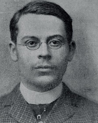
Above: R.J. Mecredy—his primary interest was in cycling as a pastime, as a competitor and as a publisher. (The art and pastime of cycling (Dublin, 1893)).
Between the 1880s and the early years of the twentieth century, in one of the least politically charged transformations of the period, Ireland’s first cycling revolution brought, quite literally, a new dynamic to Irish life. Functional benefits included greater accessibility to villages and towns, with a consequent widening and strengthening of the hinterlands of market towns. Moreover, the bicycle opened up new vistas for a growing population engaging in activity sports and recreation. As well as emerging as a competitive sport, cycling could appeal to women as well as men, offering those with leisure time the prospect of exploring the countryside on both day excursions and more extended tours. Although the attractions of cycling were to be overshadowed by the appeal and versatility of the motor car for much of the twentieth century, for a few decades from around 1880 it was cycling that paved the way for the personal mobility that is a hallmark of the modern era.
Along with these developments came new map requirements. Most of the established Ordnance Survey (OS) map products had little appeal for the new leisure groups moving across the countryside. The large-scale ‘six-inch-to-one-mile’ (1:10,560) maps depicted quite restricted areas, whilst the 205 smaller-scale ‘one-inch’ (1:63,360) maps that covered Ireland were also too fragmented for the new explorers.
John Bartholomew, W. & A.K. Johnston and G.W. Bacon
Private enterprise, most notably the Edinburgh-based firms of John Bartholomew and W. & A.K. Johnston, and the London-based G.W. Bacon, moved to meet the need by adapting OS data and publishing ‘medium-scale’ maps at the ‘half-inch’ (1:126,720) and ‘quarter-inch’ (1:253,440) scales that depicted large tracts of country on a single sheet. Bartholomew’s attractively coloured maps proved immensely popular in Ireland as well as in Britain throughout the twentieth century. They combined a clear depiction of relief variations with immense topographical detail on place-names and on the communications system—the kind of essential information needed for the new mobility.
Bacon’s maps were usually less detailed and ostensibly more dedicated to a cycling clientele. A ‘Cycling Map of Ireland with Main Roads coloured’ was issued in 1890. Produced to a scale approximating to one inch to eight and a half miles (1:545,000), the counties on this map were lightly shaded and each train station was identified by a black dot. Three inset maps depicted the environs of Belfast, Cork and Dublin. Intriguingly, and probably (as J.H. Andrews has indicated) to avoid any possible copyright issue with the OS, this map derived its base from one of Ireland first published by Aaron Arrowsmith in 1811. Other Bacon map products for Ireland included a ‘cycling and touring atlas of Ireland’ and five regional maps, drawn to a scale of four miles to one inch, which covered most of the country. Larger-scale maps for the environs of Belfast and Dublin were also produced. On these, dangerous hills and ‘hills to be ridden with caution’ were marked. The range and style of these maps conformed to a formula that was applied across the UK and which in the early 1900s evolved for motorists as well as for cyclists.
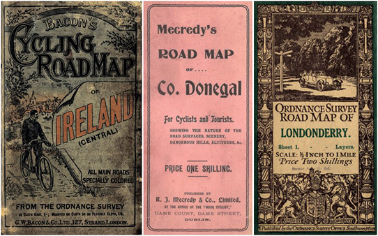
Above: The covers of some early medium-scale maps covering areas in Ireland. Whereas Bacon’s cover (c. 1890) and Mecredy’s of County Donegal (1900) feature cycling, the Ordnance Survey cover for Sheet 1 (Londonderry, 1912) gives prominence to the motor car.
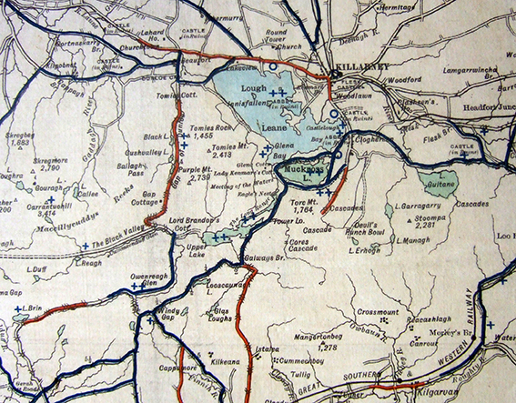
Above: The area around Killarney as depicted in Mecredy’s road map of County Kerry for cyclists and tourists (1903). Good and bad roads are respectively blue and red; the ‘+’ symbol indicates fine scenery.
R.J. Mecredy, pioneer of Irish cycling maps
Paralleling and drawing from the Bacon output, however, was a distinctively Irish genre of cycling publications. Its mastermind was R.J. Mecredy (1861–1924), himself a champion cyclist and the publisher of the Irish Cyclist magazine from 1886. The son of a Galway-based Church of Ireland rector, Mecredy gained a BA at Trinity College, Dublin, and appears to have been initially destined for a legal career, but his primary interest was in cycling as a pastime, as a competitor and as a publisher.
While still at college Mecredy was an Irish tricycle champion, and during the 1880s and 1890s he won nine Irish cycle championships. In 1890 he won four English championships at distances of from one to 50 miles. Simultaneously he developed his interests as a writer and publisher on cycling matters. During 1885–6 he became editor and proprietor of the Irish Cyclist and Athlete (founded a few months earlier by the Tralee-based printer J.C. Hodgins) and shortly afterwards he moved its office to Dublin. Summer issues for 1886 record an early initiative, a two-week cycle tour from Dublin to Killarney (and back), which attracted 35 participants.
As the many advertisements scattered through his own works and elsewhere testify, Mecredy (sometimes acting alone, on occasion in partnership with Samuel Kyle and later J.C. Percy) published prolifically on both cycling and motoring. His early 1890s works include several editions of The art and pastime of cycling and Cyclist and pedestrian guide to the neighbourhood of Dublin. Also running to several editions from c. 1892 into the twentieth century was Mecredy’s road book of Ireland, the later versions of which were in two volumes.
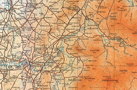
Above: Part of Ordnance Survey of Ireland 1:126,720 (‘half-inch’) Sheet 16, published in 1917, printing of July 1921. This extract depicts the Blessington area of County Wicklow as it was before the Poulaphuca reservoir was created in the early 1940s.
First secretary of the Royal Irish Automobile Club
The weekly Irish Cyclist (from 1913 the Irish Cyclist and Motor Cyclist) was especially used to promote Mecredy’s indefatigable enthusiasm for both cycling and the motor car, embracing the latter mode of transport to such an extent that he was dubbed ‘the father of Irish motoring’. The first secretary of the Royal Irish Automobile Club, he founded the magazine Motor News in 1900 and a year later he produced The encyclopaedia of motoring. In 1901 his Daimler led sixteen cars on a grand tour of Ireland that included overnight stops in Killarney and Waterville. These ventures were followed by The motor book in 1903. That year Mecredy was also pivotal in organising the famous Gordon Bennett race along the roads of County Kildare and Queen’s County (Laois). This was the first international motor race to be held in Ireland.
Complementing his books and pamphlets, Mecredy published a series of maps in which he highlighted features of particular interest to cyclists, tourists and, in later years, motorists. Using a base-map of road outlines supplied by Bacon’s, and following the type of content that that firm had included on their English county cycling maps, Mecredy coloured and annotated his editions to classify roads as good (blue), bad (red) or average (uncoloured), and to indicate the location of beautiful scenery, steep hills and good hotels. A limited selection of place-names clearly identified towns, villages and some prominent features.
Advertising that he had toured over 50,000 miles and producing what he claimed were the ‘only up-to-date maps of Ireland’, Mecredy described his maps as beautifully clear, with ‘no overcrowding of useless names’. In the early 1890s he published maps of the neighbourhood of Dublin and of Dublin and Wicklow. By the beginning of the new century he had produced a series of map sheets covering the most popular cycling districts, taking in the Dublin area, east central Ireland, Connemara, and counties Down, Donegal and Kerry. These maps, which sometimes carry G.W. Bacon print codes but which are otherwise undated, were produced with various modifications over a 20–30-year period. Revisions took account of changes in road conditions and the development of new facilities, e.g. hotels. Tellingly, later editions are for motorists as well as cyclists.
Other elements of Mecredy’s output included a special map for the 1903 Gordon Bennett race and maps covering the whole of Ireland, among them an unusual two-sheet ‘steam-rolled road map of Ireland’. The latter map, issued c. 1902, also had a tourist component, portraying—quite ineffectually, it must be said—areas of beautiful scenery and the location of golf-links. Its primary purpose, however, was to identify, with the aid of information supplied by the county surveyors, those roads that had been improved and smoothed by steam-rolling (the implication being that these were generally the most comfortable for motorists). Mecredy was a founder member of the Road Improvement Association of Ireland. Showing a very patchy distribution of rolled roads, his map represents a time when Irish roads were only beginning to be adapted to the onset of motor vehicles.
1916 setback and OS competition
Mecredy’s activities and publications flourished during the early years of the twentieth century, but his firm, by then Mecredy, Percy & Co., suffered a major set-back in 1916 when its offices, at 34 Lower Abbey Street, Dublin, were destroyed in the chaos of Easter Week. According to the subsequent compensation claim, furniture, equipment and stock to the value of over £900 were lost. The firm continued, but it is arguable that its creative energies were sapped. The Mecredy mapping enterprises in any case now faced stiff competition. Following on from a poorly judged and unattractive initiative in producing a sixteen-sheet map of Ireland at the quarter-inch scale in the early 1900s, the OS found surer ground from 1912 with the publication of its half-inch-to-one-mile ‘road maps’ that covered Ireland in 25 sheets.
These ‘half-inch’ maps, which initially appeared in two versions, hill-shaded and contoured layers, covered large tracts of country and proved popular with the motoring and touring public. They also proved to have durability, with the series acting as the most widely used medium-scale mapping of the Ordnance Survey of Ireland until they were replaced by the larger-scale Discovery series in the early 1990s. A military version, with a grid overlaid, was produced during the Emergency. Two decades earlier, the new OS ‘half-inch’ maps were no doubt also put to strategic and practical use by the various sides engaged in the struggles of 1919–23. (Curiously, however, the extent of map use during this period remains little explored.) Generations of Irish Inter Cert Geography students knew the contoured version at first hand, as a ‘half-inch’ map extract invariably featured in the mandatory ‘map interpretation’ question.
R.J. Mecredy, pioneer of Irish cycling maps, died in 1924 after a long battle with tuberculosis. Having married in 1887, he and his wife, Catherine Anne Hopkins of Oldcastle, had six children. For most of his married life he lived comfortably at Vallombrosa, Dargle Road, Bray. It is safe to say that, at the very least, he would have looked with keen interest at Ireland’s second cycling revolution during recent decades, which has seen the rebirth of urban and weekend cycling and the growth of dedicated greenway routes. Undoubtedly, were he in his prime today, this enthusiast of wheels would have been active in promoting new forms of cycling maps. Ireland has yet to see the type of sophisticated medium-scale cycling map that is now available in many other parts of Europe.
Arnold Horner formerly lectured in Geography at University College Dublin.
FURTHER READING
B. Griffin, Cycling in Victorian Ireland (Dublin, 2006).
A. Horner, ‘Charting the cycle routes of County Kerry over one hundred years ago—the Kerry road maps of R.J. Mecredy’, Kerry Magazine 26 (2016), 19–21.
J. Manning, ‘The turn of the wheel’, Irish Builder & Engineer 111 (1969), 269–73.
B. Montgomery, R.J. Mecredy: the father of Irish motoring (Dublin, 2003).