IRISH HISTORIC TOWNS ATLAS No. 26: DUBLIN, Part III, 1756 to 1847
Published in Book Reviews, Issue 2 (March/April 2015), Reviews, Volume 23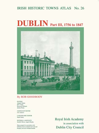 ROB GOODBODY
Royal Irish Academy in association with Dublin City Council
€30
ISBN 9781908996343
Reviewed by
Arnold Horner
Now in its fourth decade and operating under the auspices of the Royal Irish Academy, the Irish Historic Towns Atlas has produced a steady, impressive and quite distinctive flow of publications focusing on historical aspects of the built environment in selected Irish towns. The main approach has been to attempt an exploration of the development of the physical infrastructure of each town in forensic detail. In pursuing this objective, the long-time series editors, Anngret Simms, H.B. Clarke, Raymond Gillespie and Jacinta Prunty, together with the cartographic editor since 2000, Sarah Gearty, have exhibited remarkably enduring qualities of enthusiasm and tenacity.
Each atlas ‘fascicle’, or individual part, focuses on a single town or city and quite uncompromisingly follows the same format of an A3-size pack consisting of a text section complemented by a series of large-scale maps and other illustrations that come loose-leaf and which help elucidate the developing town. In the text section, an introductory essay providing a perspective on the main features of urban growth is followed by an extensive compendium of ‘topographical information’ arranged under some 22 headings (e.g. streets, manufacturing, services, etc.). As well as collating known pre-1900 references to buildings associated with a particular heading, the listing provides, in highly condensed form, information on the functional history of individual sites. In theory at least, the text section is a counterpoint to the suite of maps, which includes displays of the town as it was during the 1830s and at the present time, and which also features a selection of facsimiles and a recent large-scale vertical air photograph.
A highly laudable intention is to provide readers (or perhaps more properly viewers in this instance) with such a sufficient diversity of source material that, as well as being guided by the essay, they can do their own individual analyses. Very few other projects make source material available in such profusion, and also at such low cost. For recent fascicles a further enhancement has been to provide the material in CD as well as in paper format.
To date the project has published fascicles relating to over twenty places, ranging in size from small centres such as Carlingford, Kildare and Fethard to the large cities of Belfast and Dublin, both of which are treated by period in multiple fascicles. Dublin is consequently being explored in four periods: (I) to 1610, (II) 1610–1756, (III) 1756–1847 and (IV) 1847–1900. Fascicle No. 26, the latest to appear, deals with the third of these periods, the start and end dates of which respectively denote landmark events in the comprehensive mapping of the city: 1756 is when John Rocque produced a beautiful four-sheet map depicting Dublin with unprecedented accuracy and detail; 1847 (also, of course, the high point of the Great Famine) is when the Ordnance Survey of Ireland published their ‘five feet to one mile’ (1:1,056) plans representing the city in 33 sheets. The period is thus pivoted about the Act of Union and covers decades when the city grew rapidly, the period of ‘Georgian’ Dublin, as well as later phases of much slower development.
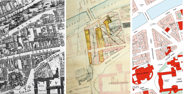
The transformation of Dublin—from Sugar-House Lane to D’Olier Street/Westmoreland Street and what is now O’Connell Bridge, showing the area in Rocque’s 1756 map (opposite page), the 1790 wide streets proposal (left) and the area in the 1840s (above).
The compiler of this fascicle, Rob Goodbody, has faced a daunting and exceptionally demanding task. He and his helpers have made a huge effort to respond, recording almost 10,000 entries in the topographical information section and, in the process, producing invaluable listings of the institutions and activities in Dublin over the best part of a century. Taking just three entry cat-egories at random, here are recorded around 2,000 streets (including lanes and courts), some 90 dyeworks and over twenty Presbyterian churches. The listings are densely structured and, perhaps unavoidably, can be confusing. Whereas the streets are listed alphabetically, manufacturing activities (for example) are listed chronologically in order of their first recorded occurrence in the city. So it is possible for breeches manufactories to be followed by mathematical instrument manufactories, comb manufactories and dyeworks. Serious users will quickly appreciate the potential of the ‘fully searchable’ CD-ROM for locating references to particular places and to particular activities.
Complementing this detail, Rob Goodbody has had tight word limits for the production of his text essay offering an overview of Dublin 1756–1847. He has had to convey the impact of the commissioners appointed to make wide streets and to create the north and south circular roads. He has had to address the ambition of the developers of the Gardner, Fitzwilliam and smaller estates, and he has had to review the significance of the canals and the railways, and such diverse developments as barracks, workhouses and cattle markets. General issues such as the creation of public spaces and town–country relations have had to be considered alongside the detail of water supply (including water fountains) and the mundanities of cesspits and dunghills.
It must have been difficult to operate across such a very broad front, but some may be disappointed that, in a rather patrician view of Dublin, quite limited attention has been given to the courts, yards and lanes and to the tenements that housed much of the population and that were crucial for the city to increase its population density yet remain so compact. As one of the atlas series editors, Jacinta Prunty (in Dublin slums: 1800–1925 [1998]), and others have ably demonstrated, tenements were already very widespread by the 1840s. Rather surprisingly, perhaps, there is apparently no comment in the atlas text on the impact of the break-up of the Gardner estate in 1846, at the very end of the period being covered. The disposal of the estate in individual lots appears to have accelerated the flight of the professionals from the north side and to have promoted the transformation of once-grand residences into tenements.
Another limitation seems to arise from the decision, presumably by the editors, to restrict the atlas to the Dublin municipal borough, an area that was mainly located between the canals. At any rate, there is room for only fleeting references to Rathmines, Pembroke and Kingstown, with consequent limitations on considering the developing periphery. Little space is given to exploring the early growth of the terraces of Kingstown or the country villas along the Stillorgan and other southside roads. Nor is there space here to expand the insight offered by Louis Cullen over twenty years ago (in Aalen and Whelan, Dublin: city and county [1992]) that the development of Pembroke beyond the canal is best appreciated as a relatively seamless continuation of the earlier Fitzwilliam estate inside of the canal.
Space limitations may also explain the curiously restricted acknowledgement of some important earlier contributions to the history of Dublin’s built environment. Prunty gets no mention anywhere, whereas the pioneering work of Maurice Craig (Dublin 1660–1860 [1952; 1980]) and the later overviews of Niall McCullough (Dublin: an urban history [1989; 2007; 2014]) and David Dickson (Dublin: the making of a capital city [2014]) do make it under ‘selected bibliography’, but as far as the essay is concerned they have just a single reference between them. Some readers may well have wished for more guidance to some of the key works of earlier periods.
Notwithstanding these rather particular qualifications, most readers will probably find the text pretty satisfactory as an introduction. They will, in any case, be at least as interested in the extraordinary resource that is afforded by the maps and other illustrations. Among the many items included here are Rocque’s large-scale plan (amended to 1769), Campbell’s 1811 City of Dublin map, and large-scale reconstructions of central Dublin in the 1840s. These are supported by a 1:5,000 modern plan and a brilliant vertical air photograph, both showing central Dublin, in 2012 and 2013 respectively. Included, too, are a wide and exceptionally interesting range of facsimile maps and views. Among these are Jonathan Barker’s 1757 plan of the first wide street, Parliament Street, and the c. 1790 plan for developing D’Olier Street and Westmoreland Street. Some of the other plans show lower Baggot Street (1790), properties in Church Street (c. 1810) and in Marrowbone Lane (c. 1811), and the areas around Christ Church and the Four Courts. It is in these very large-scale plans (some originally at 1:240, twenty feet to an inch) that the complex mosaic of small plots that made up much of the city is strikingly evident.
With these maps, it is possible to peel back layers and to contemplate the intimate spatial relationships that for long kept the poor and more affluent in close proximity in many parts of the city. This is the essence of the historic towns atlas at its best, an invitation to indulge in a strongly visual experience and to work with the contemporary evidence at first hand. With these maps, we can each take our own individual journey into the urban fabric of the past and so enrich our appreciation of our heritage. As Rob Goodbody so perceptively observed at the launch of this fascicle, the atlas is not the end point but the start. In this spirit, the atlas is not so much for the display cabinet as to be used and, if necessary, abused. There can be few documentary resources that potentially offer so much for so little cost. Buy not just one but multiple copies, and use them!
Arnold Horner formerly lectured in Geography at University College Dublin.