Seventeenth-century security concerns
Published in Early Modern History (1500–1700), Features, Issue 5 (Sept/Oct 2011), Volume 19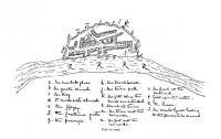
One of the earliest maps of New Ross—drawn in 1649 to facilitate a planned attack by Catholic Confederates from Rosbercon on the opposite bank of the River Barrow. (Tottenham Estate Office)
While day-to-day affairs dominate the material, the earlier books nevertheless expose an undercurrent of tension and a concern for the security of the town, the strategic importance of which was shown during the seventeenth-century Confederate Wars when Ross was held by Oliver Cromwell, who destroyed the bridge to prevent recapture. In fact, one of the earliest existing maps of Ross is a little sketch drawn in 1649 to facilitate a planned attack from Rosbercon on the opposite bank of the River Barrow. Despite its flimsy nature it is very informative, including the main streets, the outline of the town wall with its towers, and St Mary’s medieval church rising above the skyline, doubtless providing a point of reference for the attackers.