Italian echoes in the City of the Tribes pictorial map of Galway City
Published in Early Modern History (1500–1700), General, Issue 2 (March/April 2013), Volume 21, What's new in manuscript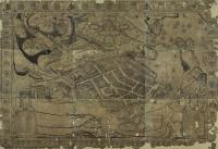 The map is in the archival collection of the library at the National University of Ireland, Galway, and has several additional elements, including the coats of arms of several families. It has been an object of interest and fascination for many, including James Joyce. James Hardiman in his History of Galway (1820) claimed that the map was originally commissioned in support of a 1651 treaty between the marquis of Clanricarde and the duke of Lorraine. In return for £20,000 to support the Royalist cause, the cities of Limerick and Galway were to be given to the French aristocrat as security. The obvious contradiction between this claim and the fact that the map is dedicated to the restored Charles II is explained by Hardiman thus: ‘After the restoration [the map] was finished blazoned and described by the Rev. Henry Joyce, then warden; and afterwards elegantly engraved, at the expense of the Corporation, and dedicated to King Charles II’.
The earliest historical reference to the map comes from a 1684 letter by William Molyneux of Dublin, addressed to his brother Thomas, who was then studying in Holland:
‘I hear the citizens of Galway, about 20 or 30 years ago, got a large map of Galway printed at Antwerp, where perhaps you may light on one, if you lay out for it. Pray, Tom, endeavour it, for I would fain receive a copy thereof. There are several in the merchants’ houses at Galway, hung up in their halls, but I fear none to be procurable.’
This claim that the map originated in the Low Countries is supported by other available evidence. The map is dedicated in Latin to Charles II by his ‘most devoted client’, a ‘citizen and pastor’, who is identified by his initials R.D.H.I. This is almost certainly the Revd Henry Joyce referred to by Hardiman, the first two initials standing for ‘Revd Fr’ in translation, and the second two being Henry Joyce’s initials. Henry Joyce had been a vicar at the collegiate church of St Nicholas up to the surrender of Galway to Cromwellian forces. In 1652 he settled in Spanish Flanders, where he remained until his death in 1697. During the seventeenth century the Low Countries was a centre of map production; Henry Joyce’s presence there in this period would support Hardiman’s assertion that he was responsible for the creation of the map.
Writing in the Journal of the Galway Archaeological and Historical Society in 1905, the editor, Prof. W.F. Trench, discounted the link to the duke of Lorraine, arguing that ‘the map would appear rather to have been issued by the Roman Catholic families, as a reminder of their recent prosperity and as an expression also of their unswerving loyalty and devotion to the Throne’. If one were to take this view it would certainly help to explain many features of the map. At the time of its creation the map appears to have been looking back to a different time. The title printed on it describes it as a delineatio historica or historical delineation of the city. It depicts a city loyal to the Crown, resisting besieging Parliamentary forces outside the town walls, while continuing to be linked with the Royalist cause through the many naval vessels shown in Galway Bay. The borders of the map also include armorial devices of the leading families associated with the city. Fourteen of these shields include the names of their respective families, representing the earliest known reference to the fourteen tribes or families of Galway. Underneath the coats of arms of the fourteen tribes is a verse in Latin which reads in translation:
‘Rome boasts seven hills,
The Nile its sevenfold streams,
Around the pole seven radiant planets gleam;
Galway, Rome of Connacht, twice equals these;
She boasts twice seven illustrious families . . .’
The map also includes a numbered list ‘by which certain note-worthy places and buildings . . . may be quickly found’. The items on this list are arranged into groups of seven or fourteen, including fourteen forts, fourteen towers, fourteen gates, fourteen main streets, fourteen lanes, seven gardens, seven markets and fourteen religious houses (seven for each sex).
That the map sets out to depict the city of Galway at a certain moment in time for apparently propagandist reasons, and also uses the numbers fourteen and seven symbolically, suggests that it is best viewed as an artistic representation of the city rather than as an accurate map. Whatever the origins or purpose of the pictorial map, it continues to be not only ‘the strangest and most interesting’ document associated with Galway City but also the most attractive. The pictorial map can be accessed on-line at http://archives. library.nuigalway.ie/citymap. HI
Fergus Fahey is Institutional Repository and Digitisation Librarian at the James Hardiman Library, NUI Galway.
Further reading
J. Hardiman, History of the town and county of Galway (Dublin, 1820).
J. Mitchell, ‘Mayor Lynch of Galway: a review of the tradition’, Journal of the Galway Archaeological and Historical Society 32 (1971), 50–5.
P. Walsh, Discover Galway (Dublin, 2001).