Dublin in the 1680s
Published in Early Modern History (1500–1700), Features, Issue 1 (Jan/Feb 2007), Volume 15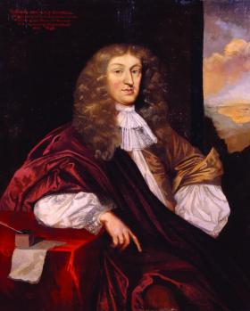
Portrait of Thomas Denton. (Tullie House Museum, Carlisle)
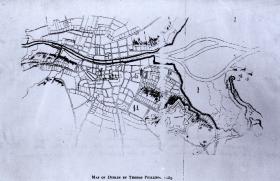
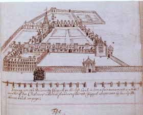
Forty years ago Gerald Simms penned a detailed word-portrait of the city of Dublin as it was on the death of Charles II in 1685. Taking as his starting-point the maps of the city prepared by Bernard de Gomme in 1673 and Thomas Phillips in 1685, and drawing on a wide range of documentary evidence, he reconstructed the topography, economic and cultural life of Dublin as it grew rapidly in size and prosperity during the later seventeenth century. He was unaware then of Thomas Denton’s description of the city, which lay buried at the back of a manuscript—a topographical ‘perambulation’ of Cumberland and Westmorland—written in 1687–8.
Thomas Denton
Thomas Denton was an antiquarian and topographer by inclination, who had been commissioned by the powerful Cumbrian landowner Sir John Lowther of Lowther to write a full description of the county of Cumberland. Denton exceeded his brief by appending not only an account of the neighbouring county of Westmorland but also descriptions of the Isle of Man and of Ireland. Most of his account of Ireland was lifted verbatim (or in a condensed paraphrase) from William Camden’s Britannia, published in English in 1610, but embedded within it is a detailed description of Dublin, drawn from Denton’s personal observation during a visit to the city, where his son was a customs officer. The date of his visit is not stated but it must have been between 1684 (the year of the fire at Dublin Castle and the opening of the Kilmainham Hospital, both of which events he records) and 1688, when he handed his completed manuscript to Lowther. His list of the leading members of the Irish judiciary takes account of James II’s Catholic appointments of 1687, suggesting that, whatever the date of his visit, he had attempted to bring his account up to date for Lowther.
Denton’s perambulation of the city provides a rare first-hand description of Dublin over 300 years ago. It begins on the city’s eastern edge at Ringsend, on Dublin Bay, where ships could anchor:
‘Here most passengers take shipping to which place from Temple Barr . . . people of all fashions are hurried by a Ringsend coach for a penny. It is a little tumble cart drawn with one horse, with a seat in the end like an open chariot, which holds 3 persons.’
The city was entered along Lazy-hill (Lazers’ Hill, now Townsend Street), ‘a long street by the river side . . . well built & inhabited by merchants, common brewers, maltsers, &c.’, and Essex Street, ‘re-edified in a very uniform manner, with cloister on each side, when the earl of Essex was deputy’ (Arthur Capell, earl of Essex, had been lord lieutenant of Ireland from 1672 to 1677). This long suburb led to the medieval walled city, from which other built-up areas extended on all sides. Denton arranged his perambulation by describing in turn the section of city and suburbs focusing on each of the seven gates in the city walls.
Expanding city
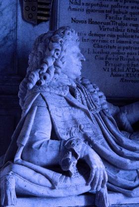
Right: Marble effigy of his patron, Sir John Lowther, in Lowther church, Cumbria.
Dublin’s population was expanding rapidly in the later seventeenth century and probably exceeded 50,000 by the 1680s. It had long burst out of the confines of its medieval walls and, with the suburbs on both sides of the Liffey, took the form of an oval, three miles long by two wide and larger in circumference than any city in Britain, London excepted. The city Denton portrayed was sophisticated and prosperous but, like all cities, wealth came with an underbelly of teeming poverty. As a lawyer and a gentleman, he gave prominence to the civic, judicial and governmental élite, but his account is particularly remarkable in the way that it populates the city’s streets with ordinary people.
He devoted most words to the city’s major buildings. Dublin Castle ‘is not large, nor beautiful; it was lately burnt [in April 1684], but rebuilt again’. Trinity College ‘hath 3 quadrangles, the 1st being the best like Trinity College in Cambridge, but not so large. The chapel is 20 yards long; large gardens, orchards & a park for the fellows’ horses’. In Christ Church Cathedral the music caught his attention: ‘They sing better in this quire than in the King’s Chapel’. In St Patrick’s Cathedral, ‘a spacious church arched over the roof with stone, with an high square steeple wherein hang 6 tuneable great bells, the same note with those in Christ Church’, he noted the massive, towering Boyle monument, which he described as the ‘noble monument of the late earl of Cork & his countess & children’. His account also provides evidence of the re-emergence of Catholicism under James II: he recorded the ‘new Popish chapel & small priory for Dominican-friars’ on the south side of the castle gate and the fact that Judge Alexander’s house on the north of the river had been converted into a nunnery.
Kilmainham Hospital
Denton dwelt in detail on the newly built Kilmainham Hospital (now the Royal Hospital), which lay to the west of the city, beyond the built-up area, and opened for maimed soldiers in 1684. The fashionable symmetry of its façades made a deep impression: it was ‘of so regular & uniform a frame’ that, as well as having an east façade facing the city, ‘it hath also a front to the south & west sides’. The north side, which contained the chapel, hall and master’s lodgings, had ‘large arched windows like church windows’. By contemporary standards its scale was huge:
‘120 yards square within the walls, four stories high & cloistered on 3 sides of the quadrangle & galleries above stairs. Within each cloister & gallery there are ten chambers & 4 beds in every chamber.’
Other public buildings included the new Tholsel at the corner of Skinner’s Row. This municipal building, which Simms described as ‘the pride of the corporation’, doubled as city hall and merchants’ exchange. Denton described it thus: ‘It’s underneath an open exchange, in the east corner in the court, & above stares a council chamber & treasury’. Of the city gaol or house of correction in the New Gate he commented that ‘the prisoners howl in the most hideous manner, when any coach or gentry pass through the same, like a den of wolves; and the poor women sing their ah! hone [i.e. ‘achone’, a lamentation] . . . with such a doleful sweetness, that it forces compassion from those who pass by’.
Of particular interest are his descriptions of the economic and social character of individual streets. He noted exactly where the markets were held on the western side of the city. Thomas Street, leading west from the walled city, had markets every Wednesday and Saturday: fuel (coal from Edough, Co. Kilkenny, peat and furze) at the low end
1685 map of Dublin by Thomas Phillips. (National Library of Ireland)
of the street; ‘hay, straw, grass, herbs & salads according to the season’ in the middle section; and corn, meal and malt at the high end. In New Row (outside the walls between Newgate and Ormond’s Gate) was a market for leather, shoes and milk, ‘both sweet & sour (for churned milk, which they call bonny clabber, is the chief food of the common people both in the city & country)’. Within Newgate itself linen and lace were sold, and there was a daily stocking market in High Street.
Social geography
His comments on the sort of people who lived in different parts of Dublin enable us to reconstruct something of the social geography of the city in his day. Castle Street was ‘the most considerable street in the town, where the richest merchants, goldsmiths, mercers & other tradesmen of eminent dealing dwell’. It also had the most taverns, because it lay close to the courts. The lawyers (‘gentlemen of the long robe, Chancery clerks & attorneys’) were concentrated in St
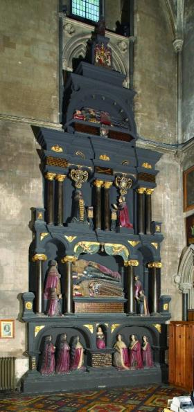
The Boyle funerary monument in St Patrick’s Cathedral, described by Denton as the ‘noble monument of the late earl of Cork & his countess & children’. (David Davison Associates)
Nicholas Lane. The narrow streets leading off St Patrick’s Street were inhabited by ‘clothiers, weavers, dyers and a number of handicrafts men’. Close by, Francis Street and the Coombe contained ‘all the worsted-spinners, weavers & mercers, who sell druggets & other Dublin stuffs (the chief manufacture of the town)’. These textile workers, he noted, were ‘generally nonconformists’.
The city’s élite were increasingly moving out to the suburbs by the time of Denton’s visit. St Stephen’s Green, laid out in the 1670s, was particularly fashionable. Denton
described it as ‘a flat square piece of ground near 500 paces over, with pleasant gravelled walks on each side [of] the square; guarded with a brest wall & shaded with lime trees’. Three sides of the square were built up and some of the houses were grand indeed: on the north side Sir Abell Ram, who had been lord mayor of Dublin in 1684–5, had ‘a double house like a paradise for beauty’. On the east side Lord Roscommon had a house ‘with large gardens; the farmer makes it a treating house of pleasure’. Sir Robert Reading had ‘a fine house’ on the west side with a tennis court in the next street. The south side of the Green remained unbuilt and lay open to ‘the prospect of a pleasant woody country under the Wicklow Mountains’.
Particularly rapid growth had taken place north of the river in the 1670s and 1680s. Until 1670 only a single bridge linked the city to the old settlement of Oxmantown on the north bank of the Liffey; by Denton’s time there were three. The expanding north
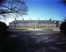
Denton dwelt in detail on the newly built Kilmainham Hospital (now the Royal Hospital), opened for maimed soldiers in 1684. (David Davison Associates)
bank suburbs contained tangible expressions of royal and governmental power. Near the modern Four Courts stood the King’s Inns (‘the public inn where the judges & principal council dine in term-time & diverse of them lodge’). To the west, beyond the ‘military-yard’, lay Phoenix Park (‘the King’s Park’), with its ‘pretty lawns, shady groves and pleasant banks all along the north side of Liffey’. It was ‘much finer & larger than Hyde Park’ in London, in Denton’s estimation. In the park stood the king’s house called ‘the Phoenix’ and Chapelizod, ‘the present lord president’s house’. The north bank of the river was a fashionable area, containing features that catered for the urban élite and reflected the taste and fashions of London. Between the city’s bluecoat hospital and the river lay ‘a large bowling-green 200 yards long with a terrace walk & banqueting house at each end’, and close by was Smithfield (‘a new market like those in London’), which mimicked London in its name and function.
Dublin was beginning to share in the urban renaissance of the later seventeenth century. Denton captures the vigour of a proud and bustling metropolis with a wealthy and fashionable élite and fine public buildings. Such expressions of civic, ecclesiastical and judicial power are the staple fare of travellers’ journals and modern
Thomas Dinely’s 1680 view of Trinity College, which ‘hath 3 quadrangles, the 1st being the best like Trinity College in Cambridge, but not so large’. (National Library of Ireland)
guidebooks alike.
Where Thomas Denton’s perambulation of Dublin differs from most early modern topographical accounts is in its systematic description of the city’s streets, enabling us to catch a glimpse of the lives of ordinary Dubliners in the 1680s, whether the weavers, the market traders or the prisoners in New Gate, howling ‘like a den of wolves’.
Angus J. L. Winchester lectures in history at Lancaster University.
Further reading:
J.G. Simms, ‘Dublin in 1685’, Irish Historical Studies 14 (1964–5).
A.J.L. Winchester and M. Wane (eds), Thomas Denton: A Perambulation of Cumberland 1687–8 (Woodbridge, 2003).