CARTOGRAPHY: When English eyes are satirising
Published in Features, Issue 1 (January/February 2021), Volume 29Maps of Ireland in caricature.
By Kieran Rankin
The shape of the map of Ireland has supplied a convenient canvas for artists to exhibit their ingenuity and imagination to amuse viewers. Although produced within various nuanced publishing and historical contexts, some vivid representations of the map of Ireland have served to entertain, influence and stereotype, often with stark allegorical or satirical purpose. Such maps have helped conflate subjective perceptions of Ireland (and the Irish) with its well-recognised and sharply delineated island image. The examples illustrated here exhibit some of the creative and sometimes politicised caricatures produced in England before Irish independence that have each communicated and reinforced a range of stylised motifs and metaphors.
Robert Dighton’s ‘Geography Bewitched’ (1793)
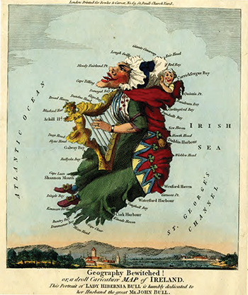
Above: Robert Dighton’s ‘Geography Bewitched! or, a droll Caricature MAP of IRELAND. This Portrait of LADY HIBERNIA BULL is humbly dedicated to her Husband the great Mr JOHN BULL’ (1793). (British Museum)
Attempts to entwine the map of Ireland with caricature were prefigured by the satirical tradition led by English caricaturists of the late eighteenth century such as James Gillray, whose work further popularised Britannia and John Bull as iconic symbols of either Britain in general or England in particular. Adapting the anthropomorphic style, Robert Dighton, a London-based illustrator and etcher, produced a ‘Geography Bewitched’ series of cartographical caricatures in 1793 that in turn depicted England, Scotland and Ireland.
His copper-engraved portrait of Ireland introduces ‘Lady Hibernia Bull’, wife of John Bull (opposite page). She is shown here in sedentary pose, facing westward, against a sky background and above a small harbour scene. Hibernia’s head, with a smiling and potato-wielding baby in her shawl behind, forms the historic province of Ulster; Leinster is formed by the rest of her shamrock-embroidered shawl; her dress drapes over Munster but with shoes shaped by the Dingle and Iveragh peninsulas, while the western province of Connacht is rendered as the perennial Irish motif of the harp. The harp has held a centuries-old association with Irish culture, along with its common use in heraldry in various Irish coats of arms since medieval times, and to this day constitutes the Irish state’s official emblem.
To assist the cartographical conceit no internal places or locations are named, but the date of the image is evidenced by the use of Carrickfergus Bay before the prominence of Belfast later ensured that the inlet became more commonly known as Belfast Lough. While artistic licence extends to omitting neighbouring Britain so as to isolate the map-image, the marriage analogy of John and Hibernia Bull heavily implies a close association, which anticipated Ireland’s political union with Britain in 1801. Dighton’s work was generally more whimsical than Gillray’s more renowned and biting canon, but examples such as this helped not only to establish the cartographical caricature genre but also to entrench the feminisation of Ireland in visual and print culture.
The whimsical and educational map: Lilian Lancaster (1868)
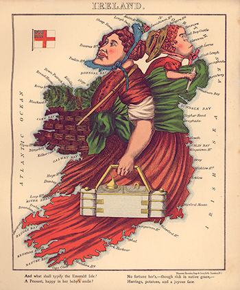
Above: Lilian Lancaster’s map, which appeared in William Harvey’s Geographical fun: being humorous outlines of various countries (1868). (Library of Congress)
Ireland was included as one of a dozen anthropomorphic maps of European countries contained in Geographical fun: being humorous outlines of various countries, a book published in 1868. William Harvey under his ‘Aleph’ pseudonym authored its introduction as well as the droll rhyming verse that accompanies the map illustrations of an unnamed artist, who is only revealed to be a teenage girl. Later confirmed to be Lilian Lancaster, she would go on to pursue a career as a music-hall entertainer, also renowned for her rapid sketching talents.
Her map of Ireland (see right) shows a stout red-haired woman laden with three burdens—a fish-wielding infant on her back; a metallic box (possibly containing provisions for a day’s work outside) in her hand; and a basket containing some green vegetation. The map is captioned with two rhyming couplets:
‘And what shall typify the Emerald Isle?
A Peasant, happy in her baby’s smile?
No fortune her’s,—though rich in native grace,—
Herrings, potatoes, and a joyous face.’
Despite the clear similarity to Dighton’s depiction of ‘Lady Hibernia’ with her baby, there are some subtle differences in that here the infant has a bulbous, simian-like jaw and the woman is shown and stated to be a peasant. The rationale behind the maps in Harvey’s general introduction explained:
‘If these geographical puzzles excite the mirth of children; the amusement of a moment may lead to the profitable curiosity of youthful students, and embue [sic] the mind with a healthful taste for an acquaintance with foreign lands. No history, no journal can be understood without a knowledge of maps, and good service is done when we make such information more easy and agreeable.’
The ‘Comic Map of the British Isles’: Frederick Rose (1880)
The late nineteenth century witnessed a series of cartographic caricatures that tracked the growing political turbulence and nationalistic sentiments then spreading across Europe. Utilising transformational advances in print technology such as chromolithography, which enabled colour outputs to be more swiftly produced in far greater quantities at lower cost, Frederick Rose’s iconic map lampooning European rivalries—‘Serio-Comic War Map for the Year 1877’ (bottom map)—was among the first mass-produced satirical maps to be disseminated widely. Such maps creatively exploited a country’s boundaries to project national stereotypes in allegorical ways that would strike a chord with readers.
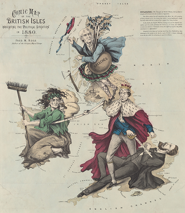
Above: Fred W. Rose’s ‘COMIC MAP of the BRITISH ISLES indicating the Political Situation in 1880’. (Beinecke Rare Book and Manuscript Library, Yale University)
The London-based Rose would later focus more sharply on the domestic political scene. His political sympathies with the Conservative Party shaped the content of his map entitled ‘Comic Map of the British Isles indicating the political situation in 1880’ (see above). Published in the run-up to the 1880 general election, the map features four main individuals—the ermine-robed and crowned Benjamin Disraeli, the incumbent Conservative prime minister; two leaders of the opposition Liberal party, Lord Hartington (lying on the ground pierced by Disraeli’s sword, labelled ‘patriotism’) and the kilted William Gladstone in Scotland (with bagpipes tagged ‘speeches’ representing his intensive Midlothian campaign); and the symbolic figure of Erin representing Ireland.
The contrast between Disraeli and Erin, sharing a mutual gaze, is stark, given Erin’s stricken appearance with dishevelled hair (with shamrock headband), as she bears burdens marked ‘famine’ and ‘distress’ on her back. The hegemony exerted over Ireland is conveyed, with Erin being literally tethered to England by a ‘union’ rein. Another political motif present is the hatchet of ‘radical support’ dangled above Erin by Gladstone. The explanatory legend describes him as ‘Delighted at the chance of severing something from England, he takes advantage of the combat in the South, to pass Ireland a weapon wherewith to cut the ties which she is learning to regard as irksome’. Erin herself is only armed with a broom inscribed with ‘obstruction’, which refers to the filibustering tactics of Home Rule parliamentarians, and she also has a tiny simian-jawed figure labelled ‘Parnell & Co’, representing the Home Rule party, furtively whispering in her ear. This latter vignette appropriates the prominent political trope in nineteenth-century print culture that often portrayed the stereotypical Irishman as simian-like in appearance and pernicious in character. The legend explains that ‘Poor Erin, seduced by evil counsellors, (who flatter her with promises of being mistress in her own house) has seized a sorry implement to break the bond which aids her so materially to support her heavy burdens’. (To Rose’s likely disappointment after the election, Gladstone became prime minister in place of Disraeli, who died the following year.)
Tom Merry’s ‘Geography Bewitched’ (1888)
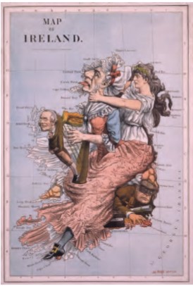
Above: Tom Merry/William Mecham’s ‘GEOGRAPHY BEWITCHED. The false Ireland & the true. Erin strangling the hag of Hawarden’. William Gladstone, leader of the Liberal Party, is depicted dressed as an old woman playing a harp while being strangled by Erin. Beneath Gladstone’s skirt emerges a masked moonlighter with gun, dagger and a case of dynamite. St Stephen’s Review, 23 June 1888. (NLI)
With Home Rule continuing to stir political controversy, the caricaturist Tom Merry (the pseudonym of William Mecham) decided in 1888 to refashion Dighton’s 1793 map using the same title—‘Geography Bewitched’ (see right). Fusing several contemporaneous motifs and metaphors, the derivative map adds the atlas convention of longitude and latitude lines to the congested and dramatic setting. The map accompanied an edition of St Stephen’s Review, a London-based periodical with strong anti-Home Rule sympathies. Subtitled ‘The false Ireland & the true. Erin strangling the hag of Hawarden’, the map depicts Erin, personifying Ireland, dressed in white and wearing a shamrock headband, tussling with the said ‘hag’, clearly resembling William Gladstone. When actually published, Gladstone, whose home estate was Hawarden Castle in Wales, was in opposition, as he had lost office as prime minister in 1886 after his attempt to introduce Home Rule failed and split his Liberal party.
Two peripheral figures also feature. The first is incorporated within the pillar of the harp which Gladstone is seen playing. Although not bearing a strong resemblance, this possibly represents John Morley, who served as Gladstone’s chief secretary of Ireland over two spells (1886 and 1892–5) and so would embody here the very instrument of Gladstone’s Irish policy. It may be, however, that this figure represents a respectable ‘everyman’ that contrasts markedly with the portrayal of a lawless and villainous second figure—a sinister-looking character, trapped below Erin’s foot, who is wearing a burglar’s mask and is equipped with dagger, firearm and a dynamite box, as well as coins shown to suggest a mercenary context. This likely symbolises the militant nationalists of Fenian secret societies who had gained acute notoriety following the assassination in 1882 of Lord Frederick Cavendish, then chief secretary of Ireland.
Overview
While representing a small sample of a narrow genre, these caricature maps of Ireland show that they can not only differ in individual purpose (e.g. barbed political comment, whimsical entertainment or education) but also exhibit general themes, which are all nested in an imperial context. Regarding production origins, their London-based artists and publishers were well placed to harness commercial resources as well as the latest colour printing techniques. As to content, Ireland’s recognisable compact shape and sharply delineated island form, whether framed in isolation or in conjunction with its larger British neighbour, proved to be a convenient and versatile canvas to convey abiding imagery with emotive impact. Furthermore, these maps exemplify how subjective characteristics of Ireland or the Irish could be ascribed, reinforced or stereotyped, while also providing the opportunity to project cultural and political relationships with Britain. Indeed, some of these maps suggest that there was a hegemonic conception of Ireland that perceived it as a distinct but diminutive entity within the British state.
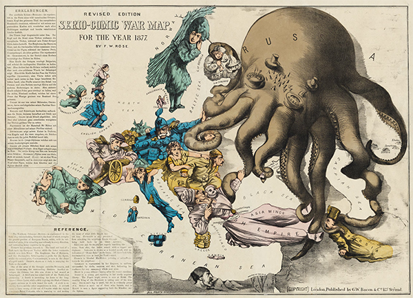
Above: Fred W. Rose’s ‘SERIO-COMIC WAR MAP FOR THE YEAR 1877’. (Norman B. Leventhal Map and Education Center, Boston Public Library)
Among the most prevalent motifs, the anthropomorphic form of Ireland as a woman has been a dominant and lasting trope (e.g. Erin, Hibernia), but her appearance could range from encumbered peasant to the projection of a pure, divine-like and empowered persona. The male figures shown are generally cast in these maps in more marginal or mocked roles, such as the pejorative ‘Paddy’ or the role of William Gladstone. Of course, there is also the symbolic use of the harp and the shamrock as well as the colour green, which have become entrenched as perennial identifying markers of both Ireland and the Irish. At junctures when Ireland was embroiled in political controversy, Rose and Merry went further than mockery by applying overt political spin to visualise personalities and encapsulate issues of the day in pithy ways that viewers could readily comprehend. Overall, the power of these caricature maps lies in how from interpretations of Ireland’s character, heritage or political condition a subjective image of Ireland’s national identity, whether whimsical or satirical in effect, could be skilfully constructed and widely disseminated. And in synthesising elements of cartography, history and art, such caricature maps constitute lasting cultural portraits of vivid aesthetic appeal.
Kieran Rankin is a political and historical geographer currently based in Trinity College, Dublin.
FURTHER READING
R. Barron, ‘Lilian Lancaster [1852–1939]’, available at http://barronmaps.com/lilian-lancaster-1852-1939/.
L.P. Curtis, Images of Erin in the age of Parnell (Dublin, 2000).
S. Houfe, The dictionary of British book illustrators and caricaturists 1800–1914 (Woodbridge, 1981).
I. Worms, ‘Fred W. Rose (1849–1915)’, available at https://ashrarebooks.com/2014/12/18/fred-w-rose-1850-1915/ (2014).


