CARTOGRAPHY: ‘Ireland’s true survay’, 1630s
Published in 18th–19th - Century History, Features, Issue 5 (September/October 2018), Volume 26A journeyman sea captain made exceptional picture-charts of Irish harbours almost 400 years ago.
By Arnold Horner
A little-noticed survey of many of Ireland’s harbours, made in the 1630s, offers some unique views of Dublin (p. 27) and other harbours at the time when Thomas Wentworth, earl of Strafford, ruled as the king’s deputy. Entitled ‘Ireland’s true survay’, this document is now part of the Portland Papers in the British Library (MS 70521). Addressed to ‘the Heigh & Meightie Prince Charles Kinge of great Brittaine France & Ireland’, a two-page preamble explains how the author, William Brooke, has drawn on his 24 years of experience to bring together a book that depicts in one place the principal harbours of Ireland, as well as some in Wales and the islands of Islay and Jura. A total of twenty Irish harbours are included, with the coverage extending from Galway and Limerick to take in thirteen places in Kerry and Cork, as well as Waterford, Dublin, Carrickfergus, ‘Oldefleet’ (near Larne) and Lough Foyle.
Above: William Brooke’s 1630s chart of the approach to Galway. A large fort is shown south of the town. (British Library)
Galway
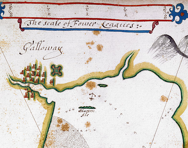
For each harbour a coloured chart is presented, drawn to scales of miles or leagues, with a representation of the ‘rising and shape of the land as it appeareth … out of the sea’. The charts also indicate anchorage points and give soundings. Brief written comments on the local resources and on the potential of each place as a source for victualling ships incorporate some valuable insights. Whereas Cork, ‘the chieffe cittye in all Monster and the richest’, is described as ‘the foremoust and best harbour in all Ireland able to harbour a thousand shipps’, ‘Galoway’ (p. 24) had ‘the fairest buildings in Ireland’; its houses were for the most part built with black marble, ‘and were it not for the mixture of some thatcht howses, it would be the fairest citie … that ever I sawe in all my travills’. Its inhabitants were rich ‘by traidinge with Spaine and France’.
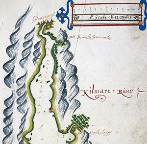
Above: The head of the Kilmare (Kenmare) River, with a village, ‘Mr Burrells ironworks’, the soon-to-be-demolished Ardea Castle and a settlement at Kilmakillogue. (British Library)
Kenmare River
The comments extend from the cities to smaller places. In County Kerry, for example, the description of the ‘famous’ Kilmare (Kenmare) River notes that, while there was a ‘village of English’ at the head of the river, ‘O’Sullivan’ was the chief governor. The area was full of woods, and ‘formerly of pipestaves, tallow and hyds’. There were also ironworks, and the chart itself (p. 25) singles out ‘Mr Burrells ironworks’—a feature that affirms the existence of an iron industry in south Kerry a generation before Sir William Petty.
Valentia and piracy
The date of compilation of this interesting document is not indicated directly, but an annotation on the title-page reads ‘Ex libris Tho Ledgarde 1633’. This date can be further confirmed from the description accompanying the chart for Valentia (p. 26), which is described as a good harbour, able to take his Majesty’s ships but not to victual them, as only beef may ‘be gotten’. Here there was no trade, ‘the people [being] poore’, and no towns, only scattered houses. But there is also reference to a bloody event that happened some 400 years ago:
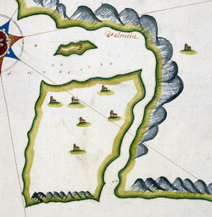
Above: Detail from the chart of Valentia harbour and island. North is to the left. The pirate ship was taken south of Beginish (the island marked ‘B’). This would be approximately in the waters bordered by Renard and the present-day village of Knightstown. (British Library)
‘Heere wee tooke the great Irish Pirat Bourque, his shippe ryding at ankor on the south syde of the island, B, beying a shippe of 250 Tonnes and 20 peeces, this about 14 yeers past.’
The island marked ‘B’ on the chart is Beginish, lying close to the eastern end of Valentia. Reference to the magnificent calendar of Admiralty court examinations relating to Ireland by John C. Appleby (1992) indicates that David Burke was the captain of a band of pirates who during 1620 seized ships, killing their crews and in one instance forcing them overboard. The pirate ship was eventually cornered at Valentia, with 28 of the pirates being hanged and seven more killed ashore. Such an event, ‘about 14 years past’, places the date of the document in 1634.
The three references in Appleby’s calendar to William Brooke, the author of the document, each relate to depositions he made during January 1634. Described as Captain William Brooke of Bristol, ‘mariner’, he had been master of the 215-ton Lion’s Ninth Whelp, one of the government ships then guarding the coast of Ireland. The two long depositions give a graphic description of a dispute with a rival captain and refer also to a priority of the day: the search off the Kerry coast for the notorious pirate Captain Robert Nutt. Brooke’s survey work was very much informed by a life of active service.
Dublin Bay
A description and chart of particular interest relate to Dublin Bay (p. 27). Even though a microfilm has been available in the National Library of Ireland since 2000, this particular chart, like the rest of the document, appears to have been largely overlooked by historians. There is no reference to it in the excellent Dublin, Part 2, 1610–1756 of the Irish Historic Towns Atlas (2008).
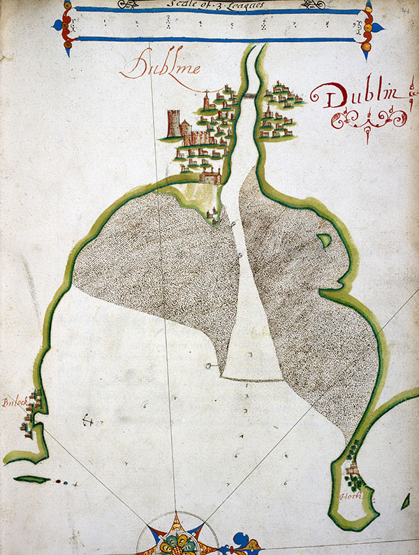
Above: Features shown on the chart of Dublin Bay include the outports of Bullock and Howth, Clontarf Island, and the crucial sand bar at the river mouth. (British Library)
In contrast to, for example, the south Kerry harbours and their surrounds, which are portrayed as having little trade and where the inhabitants are characterised as poor, Dublin is represented as a place of surplus, set in a ‘champion’ (fertile) countryside:
‘Dublin is a faire bay on the north parte thereof is the barr as you see in the Mapp, this is a great cittie and rich, the seate of the Lord Deputey. The Inhabitants rich, by traid with Spaine, France and other places; this is a plentifull countery & able to victual yor Maites shipps. The Bay is a good road in the somer for then the cittie is placed in a champion countery full of corne and pasture land. Governed by the Lord Deputie and under his Lrdps Maior and Aldermen, the Commodities exported here is tallow, hyds, salted Beefe Bandable Cloth and other things. Hee that cometh to Dublin, must ankor in Bulock Road and there take in a Pilot to conduct you over the Barr; its noe place for yor Mattis great shipps. A South South East moone maketh a full sea and soe in the Ofing follow the Soundings in the Mapp.’
These comments complement the chart, which features both the city and its setting. The city is shown as it might appear to those approaching from the sea, with built-up sections on both sides of the then wide (and here unnamed) River Liffey. A single bridge is marked, which can be related to the bridge on what appears to be the earliest map of Dublin, that made by (or for) John Speed c. 1610 or slightly earlier. Speed’s is a land-based, quite detailed city plan that identifies the principal streets and prominent buildings, such as the college (Trinity) then lying east of the city. In comparison, the imagery on the Brooke chart is generalised—inevitably so, as the chart covers the bay as well as the immediate city.
Nevertheless, some buildings are differentiated by their size and appearance. North of the river, it may be tempting to associate the prominent cross-topped church with the site of the great medieval complex of St Mary’s Abbey (suppressed around 1540). Within the more extensive built-up area of the south side several prominent buildings might be identifiable, most notably the college (the first large building seen from the sea), the bulky castle with its circular tower and perhaps the cross-topped tower/spire of Christ Church Cathedral. Based on their position and distance from the bridge, three isolated buildings seaward of the college appear to be part of an extended shore area and may denote Ringsend, then accessible directly from the city only at low tide.
Around the arcuate bay, the chart shows the anchorage beside the outport of Bullock, now a tiny harbour near Dalkey. Though unnamed, Clontarf Island and Ireland’s Eye are also evident, whilst Howth Castle appears in a woodland setting. But it is the bay itself that is of central interest, because here is an indication of both the 1630s shoreline and the extensive tidal flats and sediment accumulations where the Liffey meets the sea. The sand bar across the mouth, which all large ships had to traverse with the aid of the pilot mentioned by Brooke, is clearly marked. A dozen soundings denote depths, presumably in fathoms and at low water, in various parts of the bay. As the bar is approached, the depths get shallower, changing from seven fathoms in the outer bay to a precarious one fathom at the bar itself, then getting deeper again upriver. Three marker buoys inside the bar help indicate the channel on its southern side. For shipping approaching Dublin, and other ports at river mouths, ‘crossing the bar’ was a hazardous task, especially in poor weather.
The problem posed by the bar was eloquently described by Brooke’s contemporary Sir William Brereton. Visiting eastern Ireland in 1635, he remarked that:
‘The river is no good channel, but full of shelves and sands, and here is a very vile barred haven, over which few ships can pass that carry four hundred ton or thereabouts. The harbour here is very naked, plain and the least shelter and protection from storms that I have found in any haven; the most ships ride by the Ringe’s end, which is a point which runs into the sea, but it is so low, as it is very poor and bare shelter and little defence against the violence of the storms so as the kings ship which lies here to scour the coasts (… the Ninth Whelpe, and the Bonaventure …) is constrained to remove for harbour, sometimes under the head of [Howth], sometimes under the opposite shore.’
In the case of Dublin, the bar remained a serious navigational problem until the Liffey channel was narrowed and scoured by the initiatives of the Ballast Office in the building of the great South Wall and later the Bull Wall during the eighteenth and early nineteenth centuries (see HI 26.4, May/June 2018, pp 26–8).
William Brooke’s survey is an exceptional early record of Irish harbours as they were viewed by a seaman. In the case of Dublin, Brooke provides a rare impression of the city and its setting while it was still small and compact. Although very different, it is a useful complement to the detail in Brereton’s description and in John Speed’s map of the city c. 1610. Even more so, as a chart it has significance. It would be several decades before the mappings of Bernard de Gomme (1673) and Thomas Philips (1685), and then the charting of Greenville Collins (1693), would demonstrate the complexity of the approaches to Dublin in much greater detail.
Arnold Horner formerly lectured in Geography at University College Dublin.
Further reading
J.H. Andrews, ‘The oldest map of Dublin’, Proceedings of the Royal Irish Academy 83C (1983), 205–37.
J.C. Appleby (ed.), A calendar of material relating to Ireland from the high court of Admiralty examinations 1536–1641 (Dublin, 1992).
C.L. Falkiner, Illustrations of Irish history and topography, mainly of the seventeenth century (London, 1904).
Colm Lennon, Dublin, Part 2, c. 1610 to 1756, Irish Historic Towns Atlas No. 19 (Dublin, 2008).