Another disaster at Aughrim?
Published in 20th-century / Contemporary History, Early Modern History (1500–1700), Issue 5 (Sep/Oct 2006), News, Volume 14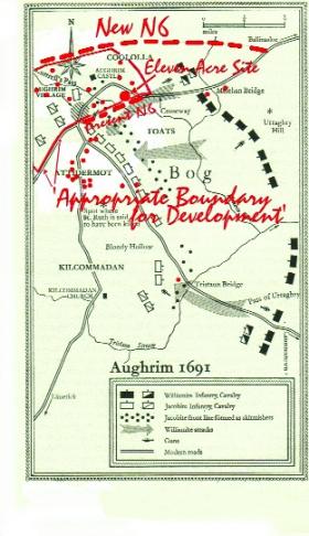
Map of the site of the Battle of Aughrim by Padraig Lenehan after G.A. Hayes McCoy’s Irish battles (1969).
The last conventional battle in Irish history was fought on Sunday 12 July 1691 at Aughrim, Co. Galway. A 20,000-strong Irish Jacobite army under the command of French Lt.-Gen. St Ruth occupied a defensive position stretching over one and a half miles along the ridge from Aughrim village. On the opposite, north-east or Ballinasloe, side of the impassable bog that separated them was a similar-sized but better-equipped army, commanded for King William of Orange by the Dutch general Ginkel. He had three Ulster battalions and large contingents from England, Holland, Denmark and France.
Both sides displayed tremendous courage, and until late in the day the heaviest casualties were suffered by the attacking force. After about five hours of fighting, most of which occurred at either end of the Irish line, sections of Ginkel’s army succeeded in getting a cavalry force, two abreast, along the narrow tóchar or causeway near Aughrim village and across to the side of the bog occupied by the Irish left wing. The Irish musketeers in the ruins of the old castle who were covering the tóchar had run out of suitable ammunition, and other forces in that area had been depleted to support the right wing. This bridgehead was quickly augmented; St Ruth was killed by a chance cannon shot; and from then onwards everything went wrong for the Irish side.
Led by Brig. Henry Luttrell of Luttrelstown Castle, and in the hope of saving their property, a section of the Irish cavalry that could have stopped the breakthrough abandoned their infantry comrades to their fate and rode off to Loughrea through an area known ever since as ‘Luttrell’s Pass’. The poet Raftery expressed the tradition of treachery: ‘Ag Lutrell’s Pass ’sea díoladh na Gaelaigh, ar scilling a’s réal amach an péire’ [‘At Lutrell’s Pass the Gaels were sold for a shilling and sixpence for two’]. By nightfall the Irish army was all but destroyed, its dead numbering about 7,000; about 2,000 of Ginkel’s men were killed.
Aughrim heralded the end of the War of the Two Kings in Ireland, with eventual total victory for King William. Aughrim, not the Boyne, was the most significant battle of the war. The surrender of Galway and Limerick, the Treaty of Limerick, the departure of the remnants of the Irish army to France, the confiscation of land, the destruction of the Anglo-Irish aristocracy and the Penal Laws were all consequences of this defeat.
The battlefield of Aughrim is in fact a vast cemetery. The Williamite dead were buried, probably in several mass graves, the locations of which are not known. The bodies of most of the Irish were left unburied for over a year. The unburied dead were a cause of great hurt and were lamented bitterly in a traditional poem:
‘Tá leasú ag Ó Ceallaigh
Nach gaineamh é ná aoileach,
Ach saighdiúirí tapaidh,
A dhéanfadh gaisce le píce.’
[‘O’Kelly has topdressing,
which is neither sand nor manure,
but lithe soldiers,
who would do deeds of valour with a pike.’]
In 1842 the English writer William Makepeace Thackeray quoted lines from an early eighteenth-century Williamite verse play, The Battle of Aughrim, that was then being staged in Galway:
‘Nothing but dread confusion can be seen,
For severed heads and trunks o’erspread the green;
The fields, the vales, the hills, and vanquished plain
For five miles round are covered with the slain’.
The battle of 1691 was, in fact, the second Battle of Aughrim. Here, on 10 January 1603, with only 280 soldiers left, Ó Suilleabháin Béara faced and defeated an 800-strong English and Irish force.
In modern times the preservation of sites of similar significance to Aughrim is commonplace in many parts of the world. Culloden is an example. The Battle of Culloden on 16 April 1745, the last conventional battle fought in Scotland, was smaller than Aughrim; the dead numbered some 1,700. Since the end of the nineteenth century Culloden has been legally protected, the surviving structures preserved, access for pedestrians enabled and interpretation handsomely provided. Ongoing restoration work recently included the felling of a 50-year-old pine forest and the removal of the main road to Inverness, which in less enlightened days had been routed through the battlefield. Culloden is deservedly one of the premier tourist attractions in Scotland.
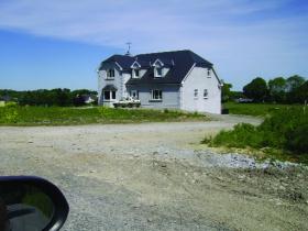
On other parts of the battlefield that are outside the 500-metre area, increasing numbers of ‘once-off’ houses are appearing. (Padraig Lenehan)
Over the centuries the physical features of the Aughrim battlefield, together with economic conditions, acted as a deterrent to excessive development. Despite the lack of any institutional defender, it still remains unspoiled to a surprisingly large extent. Now, however, it is being rapidly degraded. About 1970 Galway County Council diverted the main Ballinasloe–Galway road from the village of Aughrim and routed it directly through the battlefield. In recent years the council widened that section of road. In the process further damage was done, particularly to some of the ditches that almost certainly featured in the battle and indeed may well have been constructed or modified by St Ruth for his defensive strategy.
Owing mainly to the concerns expressed, not least in the North, more care is being taken with the preparation of plans for the new N6 Ballinasloe–Galway dual-carriageway, which is to pass close to Aughrim village. The road will not now go through the centre of the battlefield, as was feared, but it will cut off what are believed to be important sites connected with the battle and will destroy some of the physical context.
But worse is to come. As battlefields are unprotected by the National Monuments Acts, the local planning authority, Galway County Council, is the only public body possessing powers, limited as they are, to protect a battlefield by declaring it to be a place of exceptional historical interest. Naively, many of those who understand its historical significance, its national and international dimensions and its potential as a focus for North–South reconciliation assumed that the council was quietly ensuring that, at least in the matter of housing and commercial development, Aughrim would remain generally intact. Instead, in their County Development Plan 2003–2009, the only possible protectors of Aughrim selected a 500-metre radius from the centre of the village as ‘an appropriate boundary for development’. This entire area was involved in the battle. The causeway over which the Williamite cavalry crossed and the areas in which they first clashed in hand-to hand combat with the Irish infantry, the ruined castle from which the Irish musketeers covered the causeway, Luttrell’s Pass, several other identifiable battle-related sites and possible burial locations are all included. They are unprotected. Sites that are the common heritage of nationalists and unionists alike are now at the mercy of developers. On other parts of the battlefield that are outside the 500-metre area, increasing numbers of ‘once-off’ houses are appearing. In December 2005 an 11-acre site within the radius and near the causeway was offered for sale ‘for housing or commercial development’. It is a virtual certainty that this land and the human remains, Jacobite and Williamite, that may still be there will soon be covered with houses.
It is a feature of democracy that governments and public bodies usually have to respond to public opinion. A campaign of information and political lobbying for preservation and suitable development on the Culloden model, undertaken jointly by nationalists, northern unionists and others, could yet prevent another disaster at Aughrim and, in contrast to the events of 1691, result in enhanced mutual respect on both sides of the historical divide on the island of Ireland.
Maolsheachlainn Ó Caollaí is a board member of Foras na Gaeilge.