


‘ALL TO ONE SIDE LIKE MOYNALTY’—THE FARRELL ESTATE MAPS
Published in Issue 3 (May/June 2023), Volume 31By Patricia Fallon
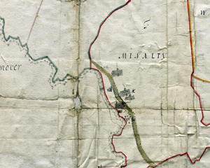
Above: Detail from the 1713 ‘Mapp of Minalty’ and surrounding townlands zoomed in on the village of Moynalty, showing the church, the mill and a nursery of young ash planted close to the river.
‘All to one side like Moynalty’ is a well-known phrase in Meath, referring to the village of Moynalty, redeveloped in the early nineteenth century, under the ownership of John Farrell, as an estate village. The result was a village with a row of buildings on one side, book-ended by newly built churches.
The Farrells were a successful Catholic family of brewers and moneylenders in eighteenth-century Dublin. The founder, John Farrell of Fingal, established himself in Merrion Square and ran the firm until his death in 1767, when he was succeeded by his son James. After the lifting of restrictions on Catholics acquiring land, James bought Moynalty and other lands in County Meath from Lord Farnham in 1790.
On his death in 1823 Moynalty passed to his elder son, John, who built Moynalty Lodge in 1825 and did much to develop the village and estate. His younger son, Thomas, inherited the house in Merrion Square and lands at Robertstown. The Farrell estate archive, which has formed part of Meath County Archive collections since 2015, consists of maps, estate ledgers and private notebooks. An interesting aspect of the collection is that it includes maps that pre-date the Farrell connection with the land. These stand as another tool allowing us to chart the development of the village from ancient to modern.
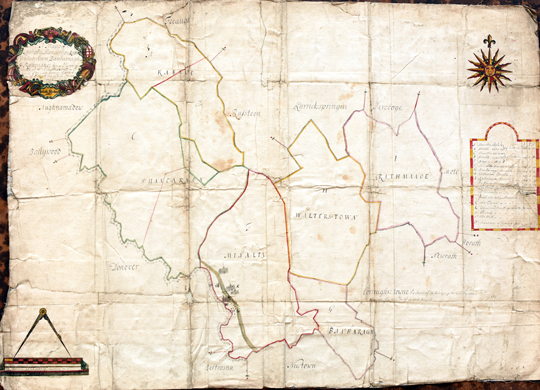
Above: The 1713 map has a key to the right-hand side, with letters denoting what the land was used for.
One of the earlier estate maps dates from 1713—a ‘Mapp of Minalty, Shancamon, Raban, Walterstown, Banbarnagh and Rathmanoe being ye Estate of the Revd. Mr. Robert Maxwell in ye parish of Minalty, Barony of Kells, and County of Meath’. The surveyor was Josiah Shadwell. The map has a key to the right-hand side, with letters denoting what the land was used for. It shows the village of Moynalty as it was, with the church, the mill and a nursery of young ash planted close to the river.
The redevelopment of the village began in 1826 and was completed by 1837. This involved the removal of mud huts and other substandard buildings. All the houses on the river side of Main Street were removed, which opened up an area down to the river. Although the village gained publicity in the nineteenth century for being ‘all to one side’, in the twentieth century houses were constructed on the river side.
During the development of a great estate it was not uncommon for entire villages to be rebuilt as an integral part of the overall estate design, and many were built close to the big house, as in Moynalty. The architecture of these villages was of a high standard and employed durable material like stone in its design.
Although this nineteenth-century village of Moynalty had its roots in the great estates tradition, there is evidence of a much earlier village on the land. The Civil Survey of 1654 recorded that the village of Moynalty contained a castle, a ruined church, two ruined mills and a fishing weir. In 1654 it was owned by Edward Betah of Moynalty, described as an ‘Irish Papist’, likely to be the same Edward Betagh who held the tithes of the parish church in 1622. Betagh had certainly become a name of consequence in Meath by the sixteenth century, for between 1570 and 1598 Betagh of Walterstown, Betagh of Rathalron, Betagh of Dunamore and Betagh of Moynalty all appear as gentlemen of that county, while William Betagh was chief serjeant of the adjoining County Cavan and Thomas Betagh was one of the gentlemen entrusted with the task of taking a muster of the inhabitants of Cavan in 1587. It is likely, too, that the castle recorded as existing in 1654 was also a Betagh possession.
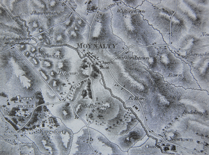
Above: Larkin’s map of 1812 shows further development a century on, with houses on both sides of the road, northwest of the church and parallel to the river. (All images: Meath County Archives)
Larkin’s map shows the layout of Moynalty village in 1812 and again shows development from our 1713 estate map, recording houses on both sides of the road, north-west of the church and parallel to the river. In 1819 James’s son, John, granted an acre of land for a Catholic parish church at the opposite end of the village to the Protestant church and donated £200 towards its erection. At the same time he donated land to the established church to widen the cemetery, build a wall around it and in the process demolish some houses in the cemetery.
The 1820s and 1830s saw the transformation of Moynalty, starting in 1819 with the rebuilding of the Church of Ireland church and the building of a new Catholic one, completed either in 1820 or 1824 at a cost of £1,000. It is likely that John Farrell first turned his attention to building his house, Moynalty Lodge. Constructed in the Regency style, this three-bay, two-storey house has a shallow hipped roof and oversailing bracketed eaves.
John Farrell then began a major reconstruction of Moynalty village, beginning in 1826 and largely completed by the time of the first Ordnance Survey mapping of the village in 1837. A comparison of our 1713 map with the first Ordnance Survey map underlines the extent of the changes. In place of the houses removed between the river and the main street was a wooded green leading to the river. Further removal of cottages or mud cabins allowed for the extension of Moynalty Lodge.
The archive of the Moynalty estate offers us an exceptional look at estate life in Meath in the eighteenth and nineteenth centuries. Estate archives have an important role to play in the archival landscape, providing access to a distinctive set of records. Until the early twentieth century, landed estates encompassed much of the land and property in Ireland, and their owners had huge influence across society. They quite often hold records of value to a wide section of researchers and because of this they provide significant access to the world of that time.
This map will form part of a collection of Moynalty estate maps which will be conserved this year. They can be viewed at Navan County Archive.
Patricia Fallon is Meath County Council Archivist and a member of the Local Government Archivists and Records Managers (LGARM).


Personal Histories
On this Day
June 30
- 1921 The brothers Richard (24) and Abraham Pearson (19) were executed by an IRA firing party on their farm at Coolacrease in the foothills of the Slieve Bloom Mountains. The pair had been court-martialled for firing on IRA Volunteers, who were cutting down trees on their land for the purpose of mounting a roadblock.
- 1690
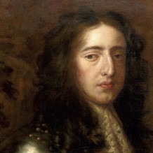
Above: William of Orange—had a close shave the day before the Battle of the Boyne when grazed by an enemy musket-ball.
Eve of the Battle of the Boyne. Early that morning, William led his multi-national army south from their camp in Loughbrickland, north of Newry, through Dundalk, where he was joined by the Duke of Schomberg, who had wintered there, and on through Ardee, arriving at the Boyne in the early afternoon. Shortly afterwards he had a lucky escape. As both armies surveyed each other across the river, exchanging sporadic fire, an enemy ball killed a soldier and two horses directly beside him, and a second, according to a witness, grazed the king’s right shoulder blade, ‘taking away his outward coat, his chamois waistcoat and his shirt and issuing a spoonful of blood’. At four in the afternoon, having had his wound dressed and his arm placed in a sling, William dined on the field and at nine called a council of war. His chief commanders, Schomberg and his cousin, the Count of Solms, sharply disagreed on tactics. Schomberg proposed that the main part of the army should perform a flanking movement, involving a roundabout march of several miles, to cross the Boyne where it bends at Rosnaree, thus attacking the Jacobites’ left flank. Solms, however, favoured a single frontal attack at Oldbridge. William eventually compromised, allowing 10,000 men to be sent to Rosnaree but concentrating the main attack at Oldbridge. Orders were then given that the troops should be ready to march at break of day, with green sprigs in their hats to distinguish them from James’s men, who, it was understood, would wear pieces of white paper. It was after midnight when William retired to his tent ‘impatient for the approaching day’.
- 1934 Nazi Germany’s ‘Night of the Long Knives’. The leader of the paramilitary SA, Ernst Rohm, and hundreds of his followers, along with dozens of Hitler’s political opponents, were murdered by the SS and the Gestapo in a two-day purge.