THE 1755 LISBON EARTHQUAKE AND TSUNAMI AND THE IMPACT ON THE COAST OF CORK
Published in Features, Issue 3 (May/June 2023), Volume 31By Michael Gibbons
The recently published Coastal atlas of Ireland suggests that the Lisbon earthquake and subsequent tsunami on All Saints’ Day, 1 November 1755, caused significant changes to the shape and geomorphology of many south-western areas of the Irish coast, including at Rosscarbery, Owenahincha, Longstrand, Kinsale Harbour, Cape Clear Island and the neighbouring areas of Baltimore, Co. Cork. Robert Devoy argues that the impact resulted in the complete alteration of the coastal shape in some areas. He gives the example of Tranabo Cove and Tralispean Bay near Lough Hyne, Skibbereen, where he claims that the tsunami wave caused extensive cliff erosion and scouring, destroying all in its path as it moved across the neighbouring headlands of the bay and generally leaving only bare washed surfaces behind it. Any coastal dwelling in its path would have been washed away. Devoy speculates that the main tsunami wave reached heights of 40–45m as it swept over the low western ground of Cape Clear Island, decreasing in height as it swept eastward—falling to 18–20m in Tralispean Bay and then to 11–14m at Harbour View, Courtmacsherry. He goes on to say that, fortunately, no major loss of life is known to have resulted in Ireland, though deaths may have gone unrecorded, particularly in rural areas. The evidence put forward for this catastrophic event is unconvincing, however, and the absence of both historical and archaeological evidence for large-scale destruction caused by such a tsunami suggests that its scale and impact are much exaggerated.
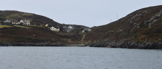
Above: Caladh Ó Dheas (South Harbour), Cape Clear Island, Co. Cork—a 45m-high tsunami would have crossed this low ridge, eliminating the settlement and destroying the late medieval church, Teampall Chiaráin, and graveyard on the other side
SPECULATION?
Boulders found within the marine sands in Tralispean Bay originated in Tranabo Cove (c. 350m away) and Devoy proposes that these were deposited by the tsunami, although a radiocarbon date of c. AD 1465 was produced from these deposits. In addition, the low-lying coastal reed-swamp wetland between Tralispean Bay and Tranabo Cove shows no evidence of any damage from a tsunami, and it has not been demonstrated that the marine sands in question or the associated boulders were deposited in this way. The morphology of the area shows no indication of the sorts of deposits that would have been left by a large tsunami wave. The reed-swamp wetland is largely flat, without any ridge of sediment that would have been deposited by a tsunami sufficiently large to transport boulders from one cove to the other. In order to have left the large-scale deposits forming the dune barrier above Tralispean Bay, the tsunami would have had to have taken an almost 90 degree turn after leaving Tranabo Cove. The topography provides no evidence for this.
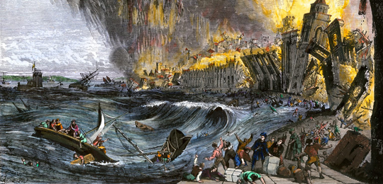
Above: A nineteenth-century illustration of Lisbon, Portugal, on 1 November 1755, when it was hit with an earthquake, a tsunami and destructive fires. (North Wind Picture Archives/Alamy)
Devoy argues that the ‘significance of the Lisbon event in understanding the operation of coastal processes in Ireland is that it shows that a tsunami can happen here, although the evidence for them may not be recognised. The event, one of the largest known to have occurred within European waters, demonstrated how such waves can change instantaneously the appearance and even the functioning of an entire coastline.’ The evidence for the size and impact of the wave is entirely speculative, however; there is no credible scientific, cartographic, documentary, oral or archaeological evidence to support an impact on the scale proposed.
SHIPS’ LOGS
One piece of historical evidence comes from the logs of ships at anchor in Cork Harbour, which record that waves caused ships at anchor in the outer harbour to yaw heavily on their moorings. A letter quoted describes the arrival of the tsunami in Kinsale:
‘… a large body of water suddenly poured into the harbour … the successive risings and fallings of the water continued about 10 minutes … By different accounts received here the water was affected in the same manner along the coast, to the westwards of this harbour.’
This clearly describes an unusually large wave but nothing on the scale proposed. In addition, a sloop and fishing-boats were destroyed in Kinsale Harbour:
‘… between the hours of 2 and 3 afternoon, … a large body of water suddenly poured into this harbour, with such rapidity that it broke the cables of two sloops, each moor’d with 2 anchors, and of several boats … which were carried up, then down, the harbour … By the direction, in which the sloops were carried down, I imagined they and several boats would have ran foul of each other … This was repeated several times … The Reverend Mr. Keef says, the perpendicular rise of the water at his quay was five feet and a half [1.65m], as he measured it, and I am told it was much higher at the market-quay, which it overflowed, and poured at the market-place … The agitations of the water were communicated some miles up the river, but as in the harbour, were mostly perceivable in the shallowest places. The successive risings and fallings of the water continued about 10 minutes … and I am told it continued its alternate ebbs and flows till three in the morning.’
Devoy’s suggested wave heights of upwards of 40m on Cape Clear Island and between 11m and 18m elsewhere along the south coast would have dwarfed the reported wave heights from Kinsale and caused devastation along the entire coast, leaving a trail of destruction in the low-lying coastal towns and villages of Kinsale, Castletownsend, Baltimore, Rosscarbery, Clonakilty and Crookhaven, not to mention the overtopping of the numerous low-lying islands in Roaringwater Bay. Such a wave would have caused a major loss of life and destroyed innumerable fishing-boats, ships and harbour installations.
CARTOGRAPHIC EVIDENCE
Damage on this scale would have been reported at the time and the absence of such reports provides strong evidence that the damage was much less severe. The Ordnance Survey Letters covering the area do not refer to any extensive damage caused by the 1755 tsunami. Nor, as far as the author can tell, has the extensive history of antiquarian scholarship in Cork since the eighteenth century produced any accounts of such damage. South-west Cork is particularly well documented cartographically; surviving maps show that the area was extensively populated in the seventeenth and eighteenth centuries and that this pattern continued into the nineteenth century without any indications of large-scale disruption. Settlements visible on seventeenth-century maps remain in roughly the same locations on the mid-nineteenth-century First Edition Ordnance Survey. Even the very low-lying islands of Roaringwater Bay, with a height of 12–30m above sea level, do not seem to have been badly affected.
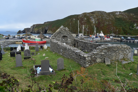
Above: Teampall Chiaráin, beside Caladh Ó Thúaidh (North Harbour), Cape Clear Island, only 4m above sea level, shows no evidence of tsunami damage.
ORAL HISTORY
There are accounts of massive changes in the landscape in some elements of the oral history, but these are undated and seem to be exaggerated narratives designed to explain landscape features rather than representing direct historical evidence. The largest changes referred to appear to be sand movements rather than the large-scale devastation that would have been inflicted by a 40m tsunami wave. Folklore of this type, intended to explain the shape of historical features, is almost universal and does not necessarily reflect any historical reality.
Moreover, the survival of relatively fragile archaeological features suggests that Devoy overstates the impact of the 1755 wave. In addition to the Rostellan and Sherkin Island tombs, the O’Driscoll Castle of Cape Clear Island (also known as Dún an Óir from an earlier fort on the same site) still stands to a height of four storeys, along with its bawn and other less-substantial buildings. So too do the remains of the island’s medieval church and associated graveyard, located just above the high-water mark close to the north harbour, though both are in a ruinous state. In addition, at a slightly lower level, the island’s holy well and an adjacent standing stone still survive. None show any indications of damage from a mid-eighteenth-century tsunami. The excavation of Skeam Church, on West Skeam Island in Roaringwater Bay, showed no evidence of settlement being disrupted by what would have been a complete inundation of a very low-lying island. The survival of fragile pre-eighteenth-century structures and the lack of historical accounts of a catastrophe both suggest that the evidence for the reshaping of this part of the Cork coastline (well outlined by Devoy) will require a very different explanation, unrelated to the 1755 tsunami event. The tsunami theory seems to have been formed as a result of trying to match folklore accounts of the supposed impact of large waves with a possible historical cause rather than being derived directly from any of the physical or historical evidence. A mid-eighteenth-century catastrophe on the scale proposed would have left a much larger archaeological and historical signature and the absence of such a signature suggests that it simply did not happen.
Michael Gibbons is an independent archaeologist and a specialist in upland and coastal archaeology.
Further reading
A. Cronin, R. Devoy, D. Bartlett, S. Nuyts & B. Dwyer, ‘Investigation of an elevated sands unit at Tralispean Bay, south-west Ireland—potential high energy marine event?’, Irish Geography 51 (2) (2019), 229–60.
R. Devoy, ‘Impacts and implications of tsunami on Ireland’, in R. Devoy, V. Cummins, B. Brunt, D. Bartlett & S. Kandrot (eds), The coastal atlas of Ireland (Cork, 2021), 38–40.
K. Hickey & A. Beese, ‘The 1755 Lisbon earthquake-tsunami and the West Cork coast’, in blog from Deep Maps: West Cork Coastal Culture (2018) (http://www.deepmapscork.ie/past-to-present/climate/1755-lisbon-earthquake-tsunami-west-cork-coast/).
A. Santos & S. Koshimura, ‘The historical review of the 1755 Lisbon tsunami’, Journal of Geodesy and Geomatics Engineering 1 (2015), 38–52.