Mapping the past
Published in 20th-century / Contemporary History, Issue 2 (Mar/Apr 2008), News, Volume 16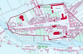
Fethard in 1840 (detail). The property units and circuit of the town wall are depicted. (From Irish Historic Towns Atlas No. 13 by Tadhg O’Keeffe)
In recent years Irish scholars have become increasingly appreciative of early maps as a record of past landscapes, past geographical knowledge (and ignorance) and past geopolitical attitudes. To appreciate this trend one need only consider the successive fascicles of the Irish Historic Towns Atlas, the numerous early-map facsimiles in the Atlas of the Irish rural landscape, and the publications of individual writers like Andrew Bonar Law, Patrick Duffy, Arnold Horner, Patrick O’Connor, Jacinta Prunty, William J. Smyth and others. Some of the principles involved in this kind of study are easily stated. For instance, to get the most from an early map we need to know why, when and how it was made. We may also need to compare it with maps of other regions and possibly other countries. Accordingly, many geographers, especially outside Ireland, have become interested in map history as a semi-independent subject with its own lecture courses, its own conferences and exhibitions, its own scholarships or fellowships and, most important, its own literature.
For one reason or another, this literature has never been easy to find in Irish libraries. To help improve matters, some 670 books and 2,300 pamphlets on map history were presented in 2005 to the library of NUI Maynooth, where they are now available for study by both members and (on application) non-members of the university. Accumulated over a period of more than 50 years, this collection includes narrative essays, monographs, higher-degree theses, map catalogues, cartobibliographies, thematic dictionaries and reprints of early atlases. Some of the books relate to the histories of subjects closely connected with cartography, such as surveying (including a number of texts published before 1850), geodesy, metrology, field astronomy, exploration and discovery, place-names, draughtsmanship, calligraphy, printing, bibliography and textual criticism. There are also several works on post-1930 cartography, most of them now historical relics, and a number of elementary school texts belonging in the same category.
Serial publications include complete or almost complete sets of The Map Collector, Sheetlines (specialising in Ordnance Survey maps), the Map Collectors’ Series and Imago Mundi. Individual works of particular interest are Abraham Ortelius, The theatre of the whole world (1606, reprinted 1968); Gerard Mercator, Atlas or a geographicke description of the world (1636, reprinted 1968); John Ogilby, Britannia (1675, reprinted 1970); R. A. Skelton and John Summerson, A description of maps and architectural drawings in the collection . . . at Hatfield House (1971)—more important than its title might suggest; and Harry Margary, The old series Ordnance Survey maps of England and Wales, scale 1 inch to 1 mile, in eight volumes. Most of the published literature on Irish map history is represented, comprising about 20% of the collection and including such noteworthy publications as Y. M. Goblet’s rare La transformation de la géographie politique de l’Irlande au xviie siècle dans les cartes et essais anthropogéographiques de Sir William Petty (1930); G. A. Hayes-McCoy’s Ulster and other Irish maps c. 1600 (1964), also something of a rarity; and a complete set of the one-inch Ordnance Survey maps of Ireland, original hill edition in 205 sheets, republished in 1989 by Phoenix Maps of Dublin.
The pamphlets cover the same range of subjects as the books, being mainly conventional academic articles with some unpublished conference and discussion papers, as well as a selection of ephemera and minor items such as book reviews, obituaries and lecture hand-outs.
Apart from printed matter, there is also a small amount of the donor’s own unpublished personal research material on compact disc. This presentation was not conceived as any kind of personal memorial, however. On the contrary, it is hoped that in the fullness of time other scholars will keep the Maynooth collection up to date by donating books and pamphlets on the history of cartography (especially their own writings) that might otherwise be unavailable in Irish libraries.
J. H. Andrews was formerly an associate professor in the Department of Geography, Trinity College, Dublin.