
Two hundred years ago a decision was imminent on one of the great engineering projects of nineteenth-century Ireland. Arnold Horner outlines some key events in the building of Dún Laoghaire harbour, including the crucial role played by the great civil engineer John Rennie.

How to access Ireland’s principal city from the sea was a focus for intermittent debate over much of the eighteenth century. Sand bars, a silting river and an exposed stormy bay were among the hazards that demanded either solution or amelioration and which became more immediate as the size and volume of shipping increased. Various options were mooted and on occasion actually implemented, most notably the great south wall that helped channel the River Liffey. Surveys of the bay were taken too, including one in 1800 by Captain William Bligh of HMS Bounty fame. A particular issue was safe anchorage for ships caught in the open bay during stormy weather, and a widely canvassed solution was the building of either a pier or an artificial harbour to give shelter. But opinion was divided on the best location for such an initiative. Within Dublin Bay, Dunleary (as it was then spelt) and Sandy Cove on the south side and Sutton Creek on the north side were among possible options. A controversial harbour at Howth, to serve for the mail packet-boats to Britain, was given the go-ahead in 1807, but its small size and location limited its potential as an ‘asylum harbour’ for vessels using Dublin Bay.

A grim event in November 1807 highlighted the lack of shelter in the bay. Onshore spectators watched helplessly during a storm as strong seas swept two vessels onto the rocky shore west of Dunleary. Nearly 400 lives were lost. A strong lobby now emerged, pushing the humanitarian and commercial arguments for serious investment to avert further tragedies. Meetings and petitions were organised, with a Scandinavian-born Dublin shipbroker and former sea captain, Richard Toutcher, particularly prominent in the campaign. The government authorities, acutely aware of the communications inadequacies starkly exposed in 1798, had their own strategic concerns to develop more secure and less weather-dependent facilities. With further shipwrecks and over 10,000 vessels (‘exclusive of coasters and fishery vessels’) entering Dublin port each year during the early nineteenth century, the need for a solution was urgent.
A persuasive pamphlet by Toutcher in 1811 projected a 1,500ft (460m)-long single pier, and led to the chief secretary promising that if the money and materials were available, official support would be given for an asylum harbour at Dunleary. As the nearby local quarries were small, a key issue was an adequate supply of construction materials. Toutcher worked intensively to secure leases and access to the commons at Dalkey Hill, over two miles to the east. A further challenge was the transport of the hill’s abundant granite rock across the still largely rural landscape to whatever site was selected. By early 1814 the crucial access to the Dalkey lands had been negotiated. Dedicated to the project, and paying himself for the cost of the initial reports and estimates needed to convince government, Toutcher secured a £5,000 grant to allow the great Scottish-born engineer John Rennie (1761–1821) to make a preliminary survey.
Building the east pier

The Dunleary Harbour Act was given parliamentary approval in June 1816. Immediately after, the commissioners, on Rennie’s recommendation, appointed John Aird, then working at Howth, as resident engineer. Aird estimated the start-up costs, which included 200 trucks and wagons, twenty quarry cranes, a (stationary) steam engine and a mortar mill, as well as railway metal and some buildings, at £30,000. Much of the preparatory work, including the rail line, was completed by March 1817. Shortly before the lord lieutenant formally laid the first stone for the pier on 31 May, the quarrying contracts were advertised. Only about then was a final decision made to project the pier from an eastern site across the Codling Rock, with a further late change, shown in an 1817 plan, being to add an extra 1,000ft to the pier’s length.

Scenes of intense activity must have marked the work that now got under way in earnest. Upwards of a thousand men worked at the quarries and at the harbour site, and up to 300 wagons of rock were being brought from Dalkey each day. Smaller quarries at Glasthule and near the harbour site were also active. Inevitably, perhaps, the project was punctuated by tensions. The five commissioners, mainly with property and legal backgrounds, had their own preoccupations and occasionally particular personal agendas. When they decided to check on the precise volume of stone by insisting on a detailed survey of the Dalkey quarries, the professional, Aird, took offence, giving vent to an ‘improper warmth of expression’ for which he had subsequently to apologise rather abjectly. Nonetheless, he was again sharing his opinion of the commissioners with Rennie in April 1818, observing that ‘their proceedings are not always marked with any great degree of steadiness, their minds would seem to be floating out of complete chaos . . .’.
The west pier

Rennie had mooted a second, west, pier as early as April 1815, seeing it as essential to the asylum objective and as a means to prevent sand accumulation in the shelter area, but priority was given to a single pier initially. Only in late 1818 did much focus return to the west pier. Rennie submitted estimates. The chief secretary was lobbied. The admiralty enquired how a pier extension would ‘benefit H.M. ships’. In August 1819 the new pier, projected to extend over 5,300ft from the notorious ‘Chicken Rocks’ near the original village of Dunleary, was officially approved, with the relevant act being passed in 1820. With most of the rail line and machinery already on hand, Rennie estimated its cost, again very precisely, at £269,159. When the newly crowned George IV visited Ireland a year later, much work was still in progress. Nonetheless, he marked his departure by renaming Dunleary as ‘Kingstown’ (a name that would hold for a century) and by designating the great project a ‘royal harbour’.
John Rennie died, aged 60, in October 1821. Mourning the loss of his boss and ‘protector’, John Aird quickly wrote to Rennie’s son, also John and a civil engineer, urging him to take over his father’s project, but it was only in 1826 that the commissioners formally appointed him as directing engineer. Later work, continuing into the 1840s, included a redesigned harbour entrance. Originally estimated to cost over £800,000, the treasury put the final cost at under £700,000, a figure that attests to the planning and management of a project with many uncertainties about its execution.
Conclusion

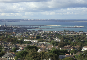
An early state initiative in infrastructure development, Dunleary harbour was one of the greatest engineering projects undertaken in nineteenth-century Ireland. Providing some 250 acres (100 hectares) of sheltered water and today most prominently a major recreational space, many millions of travellers have passed through the harbour during its almost 200 years. Developments in air transport, shipping and in Dublin port have changed its role, yet it remains—as does the much-incised Dalkey Hill—an enduring monument, much appreciated by a variety of users, a permanent testament to the initial vision and persistence of Richard Toutcher, the skills of a master engineer and his son, and the largely unrecorded input of thousands of construction workers.
Libraries and record offices in Ireland and Britain preserve many documents linked to the early years of this project. A great story has yet to be told in detail. Over 100 letters, memoranda and maps concerning the harbour are among the Rennie papers in Edinburgh and at the Institution of Civil Engineers in London. Over 2,000 records are in the OPW collection at the National Archives in Dublin; other important material is in the Royal Irish Academy and the National Library of Ireland. Sadly, one of the chief NLI records is a small collection of notes and memoranda documenting both the initiatives and the disappointments of Richard Toutcher. A passionate man, he was never properly recompensed for his outlay in freeing up the Dalkey granite and seeding the project, and the commissioners, some of whom he later despised, offered him only a bit part in its execution. Bankrupt and apparently very bitter about their ‘blunders’, he lived to see the main harbour largely completed, dying, aged 83, in 1841. As the bicentenary of the harbour approaches, his crucial early input deserves to be better appreciated. HI
Arnold Horner formerly taught geography at University College Dublin.
Further reading
J. de Courcy Ireland, History of Dún Laoghaire Harbour (Dublin, 2001).
A. Horner, ‘John Rennie’s documents relating to the planning of Dunleary Harbour 1815–16’, Dublin Historical Record 59 (2) (2006), 182–200.
J. O’Sullivan & S. Cannon (eds), The book of Dún Laoghaire (Blackrock, 1987).
P. Pearson, Dún Laoghaire–Kingstown (2nd edn, Dublin, 1991).