“An eye on the Survey”
Published in 18th–19th - Century History, Features, Issue 2 (Summer 2001), Volume 9In 1824, the British government decided to initiate a comprehensive series of six-inch maps of Ireland, the first of its kind. The project was entrusted to the British Board of Ordnance, a military body responsible for mapping, which authorised Col. Thomas Colby to supervise. Since the maps were to be based on townland divisions, Colby ordered a study of existing boundaries. Irish engineers, under the control of Richard Griffith, conducted this work, known as the boundary survey. Immediately, Ordnance Survey staff began mapping: an elite corps of Royal Engineers, an ordinary corps, known familiarly as sappers and miners, and civilians recruited locally.
The topographical department
Colby, along with Capt. Thomas Larcom, director of operations in Ireland and his next in command, wanted to produce the best maps in the world in a technical and literary sense. To this end, they considered it essential to record accurate versions of placenames. Irish scholars were employed to ensure that correct forms were put on the maps. Known as the topographical department, these scholars studied written records, ancient and modern, and traced changes in placenames over the centuries. They then conducted extensive fieldwork, and recorded current pronunciations and spellings. They travelled all over Ireland during the 1830s, and followed the route of the Royal Engineers who were mapping the country from North to South.
Wexford town, 1830s. (Ordnance Survey, first edition 1839-40)
As the Ordnance Survey progressed, topographical department scholars compiled an extensive archive on local history, tradition, topography, physical and material remains, and an impressive portfolio of drawings. References to sites and ruins of historical or archaeological significance were marked on the maps. In addition to enhancing the maps, Larcom realised that topographical department research would greatly supplement them, if produced in book form. With Colby’s sanction, he instructed military and civilian staff to collect information on local conditions: geography, geology, physical science, zoology, botany, society, economy, historical and cultural traditions. The combined results would be published as a series of encyclopaedic county ‘memoirs’ that would explain as well as delineate the landscape.
Public reaction
The public responded in diverse ways to Ordnance Survey work, positively and negatively. In examining perceptions and reactions, we must consider the different groups concerned, and distinguish between official intent and practice, between popular and elite attitudes, and between responses to mapping and to memoir investigations. We must examine the motivation of Ordnance Survey officials, the attitudes of influential figures such as clerics, landowners, and newspaper commentators, and the perspectives and responses of people who assisted or obstructed the survey.
From what we know of official perceptions, military and civilian personnel viewed its activities and their own involvement in a very positive light. A list of guidelines drawn up for military staff warned against idle talk and against boasting. In private correspondence, Larcom declared that the Ordnance Survey was the most important work in progress throughout Europe. Civilian staff praised the Ordnance Survey and expressed pride in being part of it. Their only complaints, repeated and consistent, were about money. One young recruit, John Keegan, kept a diary of his experiences as an assistant surveyor. His entries capture a sense of enthusiasm and excitement about the enterprise. Keegan saw Ordnance Survey employment as providing steady work and opportunities for travel and socialising.
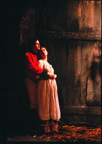
Yolland (Damien Matthews) embraces Máire (Fiona McGeown) in the Abbey Theatre’s 2000 production of Brian Friel’s Translations. (Tom Lawlor)
His lively accounts of activities such as Novena-going to meet women, mixing with local people in temperance societies and (ironically) in public houses, and attendance at political rallies testify to the camaraderie as they travelled. However, Keegan was keenly aware of his duties and committed to fulfilling them, in spite of opposition. On one occasion, when prevented from surveying, he made repeated efforts before eventually managing it in the dark, and he immediately left the area. Nevertheless, Keegan was not deterred from Ordnance Survey work, or troubled by any self-doubt. In fact, he seemed almost indifferent to and unmoved by adverse reactions. When people in ‘wild and unfrequented places’ were civil to Ordnance Survey workers ‘although [they were] in a semi-official government employment’, Keegan simply registered his surprise.
National betrayal?
Letters written by the topographical department staff, particularly the great Irish scholar, John O’ Donovan, show the pride they took in their work. O’Donovan did not consider his work on placenames as a betrayal of his nation, or as a factor in the destruction of Irish culture, as some modern critics imply. Quite the opposite: he was forthright in his praise of the Ordnance Survey as a great national endeavour and declared that amor patriae motivated him. Others such as the distinguished antiquarian artists George Petrie, William Frederick Wakeman, and George Du Noyer, and the reputable Irish-language scholar, Eugene Curry, concurred. They believed that the Ordnance Survey was undertaking pioneering research on Ireland’s history, topography, archaeology, literature, and language, work that would illuminate Irish and European scholarship. They hoped that memoirs would remedy the defects of existing histories: counter partisan propaganda, disprove errors, deflate exaggerations, and supply the deficiencies in the historical record. They praised the Ordnance Survey for its timely research on the Irish language in the face of rapid Anglicisation, and for its rescue work on ancient sites, monuments and antiquities that were in danger of destruction or dispersal. Finally, conscious of European historicism, topographical scholars saw the Ordnance Survey as promoting a similar revolution in historical methodology in Ireland through its scientific and source-based (literary, physical and material) approach.
In later years, these scholars frequently acknowledged the Ordnance Survey as an invaluable and formative influence on their intellectual development. It introduced them to the ancient sources, familiarised them with the best of modern scholarship at home and abroad, and trained them in the critical, scientific and comparative approach. Numerous publications bore the imprint of such apprenticeships, as the authors cited information acquired during Ordnance Survey work. In spite of such ringing endorsements, however, topographical department scholars were not ignorant of, or oblivious to, negative perceptions of the Ordnance Survey. O’Donovan failed to recruit two Monaghan schoolteachers who feared that government work would conflict with their religious beliefs. Nevertheless, just like Keegan, O’Donovan recorded the incident without any indication that he felt compromised as a Catholic in Crown service.
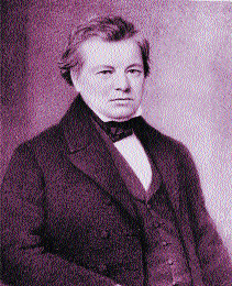
John O’Donovan-the Irish scholar praised the Ordnance Survey as a great national endeavour and declared that amour patriae motivated him. (National Gallery of Ireland)
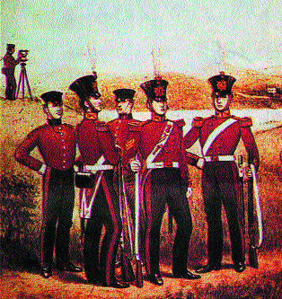
Royal Sappers and Miners at work.
Proof of good government?
In the early nineteenth century, policy makers and intellectuals generally viewed mapping and surveying as valuable scientific endeavours, and as proof of good government. Larcom and Colby perceived the Ordnance Survey in these terms, as a great civil and utilitarian venture. Like many contemporaries, they were deeply concerned about the perceived ‘Irish problem’, were committed to social reform, and were intent on using Ordnance Survey maps and memoirs to effect change. Influenced by the statistical movement, and the optimistic spirit of the Enlightenment, they believed that knowledge was the key to improvement. If Ireland’s elite were made aware of the causes of its economic and social problems, and were informed on how to harness the country’s natural resources, they could change things. Economic regeneration and social reform would lead to political stability and moral improvement. Ideologically convinced of these premises, and motivated by reformers’ zeal, Larcom and Colby saw the memoir scheme as an unparalleled means of improving Ireland.
Although government and intellectuals were overwhelmingly favourable towards the Ordnance Survey, they expected opposition. The Spring Rice Commission of 1824 that established the survey recognised the political context of mapping Ireland. It had been used historically as a tool of conquest and all previous surveys had ‘originated in forfeitures, and violent transfers of property’. The commissioners discussed the state of the country, the character of the people, and the possibility of ‘obstructions on the part of the peasantry’. Civil engineers were questioned about private surveys, and testified that they had experienced difficulties at times. Richard Griffith described how people sometimes threw down his equipment, which he attributed to ignorance, not political opposition. Another prominent civil engineer, William Edgeworth, found that people were generally co-operative, although he was very careful to seek their goodwill before beginning. He paid people before setting marks on their land, he never carried firearms, and he always explained how the survey would benefit people. Unlike Edgeworth, David Aher, a civil engineer employed as a tithe commissioner, encountered great hostility and was repeatedly prevented from surveying. Such cases alert us to contemporary expectations and remind us that mapping was already a contentious issue.
In anticipation of conflict, the government introduced an act to deal with the perceived threat of ‘wanton crime’ against men and equipment. Over twenty years later, Colby claimed that the points used in the triangulation were preserved by the provisions of the act, and by the good feeling of the inhabitants, but there is evidence to the contrary. Royal Engineers complained about interference with equipment, destruction of trigonometrical stations, and removal of surveying poles. They pressed officials in headquarters to seek the help of ecclesiastical, civil, and military authorities to guard equipment, to protect staff, to condemn acts of violence, and to warn people against further incidents. O’Donovan suggested merrily that Colby should try to revive the ancient Roman cult of Terminus, the God of boundaries, ‘among the Irish, that they may pay respect to his trigonometrical stations’.
Shortly after beginning work in County Derry in 1825, Capt. Waters, the commanding officer there, suggested petitioning the Catholic bishop for assistance, and in response, clergymen were urged to use their influence with the people. Capt. Bolton recommended that the police be used to caution the public against interference. Other Royal Engineers successfully lobbied Col. Colby to organise a police guard on stations and equipment.
‘Consistent with imperialism’?
Some people expressed resentment against mapping in other ways, such as denying surveyors’ access to their land, or refusing to supply information about boundaries. Contemporary reports testify to popular suspicion about the reasons for mapping. The Nation newspaper described the Ordnance Survey as ‘consistent with imperialism’ because it enabled the levying of taxes, surveillance, and military planning. Although this judgment is in stark contrast to the standard newspaper commentary, it should not be dismissed. Read in conjunction with other sources, it reflects at least an element of popular opinion accurately. David Aher, in his evidence to the Spring Rice Commission, attributed opposition to the ‘agitated’ state of the rural poor, who feared that land surveys were a preliminary to a military operation. William Stokes described how people in County Derry thought Ordnance Survey stations were military posts ‘to “spy out the nakedness of the land” and to mark the point from which the country below could be most easily commanded by artillery’.
As well as cases of suspicion, muted resentment and passive resistance, there were more serious incidents of sabotage and violent conflict. Boundary surveyors, Royal Engineers and civilian assistants were threatened or attacked on various occasions. Ordnance Survey records describe assaults on staff and official responses, although they do not usually discuss the cause of disturbances. Major Waters reported an assault by three men on a party consisting of three soldiers and seven civilian assistants as they returned to Ordnance Survey headquarters in Galway in May 1838. One Engineer was stabbed in the incident, the Ordnance solicitor initiated proceedings against the men involved, and the perpetrator of the stabbing was sentenced to two years imprisonment with hard labour.
In a study of the Ordnance Survey, A Paper Landscape (1975), John Andrews suggested that people thought it was part of a government plan to use a secret weapon to suppress agrarian disturbances.
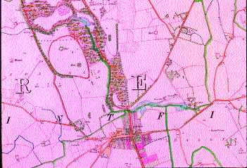
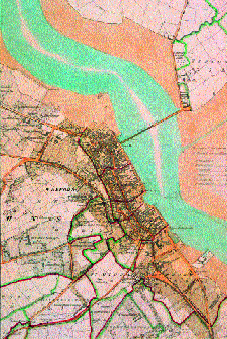
Saintfield, County Down, 1830s. (Ordnance Survey, first edition 1833-34)
Certainly, rural tensions were a key factor in provoking resistance, and local grievances about social and economic issues were the immediate cause of conflict rather than political or national causes. The agitation over tithes in the early 1830s was responsible for much of the hostility and provoked some particularly fraught episodes. John Keegan described one such incident in the Walshe Mountains, County Kilkenny, in March 1839, caused by a dispute between locals and the Protestant clergyman. Local people accused the rector of bribing the boundary surveyor to mark certain land as glebe, making it liable for tithes. The like had occurred at White Mountain Common or Bantry Common, County Wexford, the year before over boundary land held in commonage. Local inhabitants refused to allow the land to be surveyed, and the militia was drafted in to prevent a confrontation.
Military or civil?
After attacks on military and civilian staff, at work, off duty, and even in their quarters, Capt. Stotherd suggested that soldiers should carry their ‘their bayonets when out after dusk’. Colby refused the request and authorised police protection instead. From the start, the issue of arming military staff was contentious. High-ranking officials clashed over whether or not to make the civil survey of Ireland a military one. In July 1825, Col. Palsey warned Colby that ‘the men of that company will be ruined as soldiers’ unless they were armed. Griffith, whose boundary department staff was involved in controversy on more than one occasion, was also in favour of making the Ordnance Survey an armed force. Nevertheless, irrespective of protest, Colby was adamant that it should remain a civil project. Engineers were prohibited from carrying arms, and from assisting militia in local conflicts, in spite of requests from magistrates. Popular perception of the Ordnance Survey was a major concern for Colby. He emphasised the importance of good relations with the public, and instructed staff how best to address people.
Ordnance Survey memoirs
Just as the intelligentsia praised Ordnance Survey maps, they promoted the memoirs as having the potential to advance scholarship, and to provide essential practical information on natural resources, social and economic conditions. This promise was never fully realised because only one volume was published, Memoir of the city and north western liberties of Londonderry, parish of Templemore (1837). Although the series was never published, memoir researches continued until 1842, when the government stopped the scheme for economic and political reasons. Using these materials then, we can examine public responses to memoir investigations, which were conducted largely without incident and were received almost universally with goodwill.
People with propertied, commercial and industrial interests, in particular, anticipated great benefits from memoirs. They intended to use statistical and scientific data on local conditions and on natural resources to develop industry, agriculture and trade. The historically minded welcomed the prospect of a systematic study of history, archaeology and topography, on a local level and as part of a wider national survey. Thomas Davis claimed that memoirs would write a new and objective history of Ireland, thereby ending political divisions, fueled by conflicting interpretations of the past. The press celebrated memoirs as a means of countering partisan anti-Irish propaganda, of disproving antiquarian theories that espoused a biblical model of the past or pagan cults, and of discrediting amateurish practices based on speculation.
Adverse effect of ‘Irish hospitality’
Many landowners and professionals were members of antiquarian or literary societies, amateur collectors, and authors of local studies. They introduced Ordnance Survey staff to other antiquarians, showed them the antiquities of the region, and allowed them to use their private museums and libraries, which often held valuable artifacts and manuscripts. So gracious and so inviting were many landowners that O’Donovan complained about the adverse effect of ‘Irish hospitality’ on his progress. Proprietors who held legal or political office, land agents, bailiffs, tithe and cess collectors supplied the Ordnance Survey with voluminous records and shared their expert knowledge.
Clerics, schoolmasters, small farmers and labourers, were excellent sources of information, especially in the countryside where there was continuity of settlement, and in Irish-speaking or recently Anglicised areas where oral culture was still strong. In rural Ireland, generations of families often lived in the same place and preserved traditions about local place-names, history and legends, which they imparted to Ordnance Survey staff. Topographical department scholars sought out teachers and clerics in particular, who often traveled with them to procure information, pointed out historic and archaeological sites, introduced them directly to ‘qualified inhabitants’, and put them in contact with knowledgeable people elsewhere. Catholic priests, especially, were very useful because they had so many parishioners. O’Donovan wrote that letters of introduction from Catholic bishops were better than credentials from the king. As for schoolmasters, teaching often supplemented their main interest in Irish scholarship. These scribes allowed topographical staff to examine, to copy, and occasionally to purchase their manuscripts. Some manuscripts now in national keeping were collected from poor scholars at this time.
Some people charged Ordnance Survey staff for information. Members of the topographical team complained that their wages were insufficient to meet the ‘considerable expense in entertaining old seanchies’. O’Donovan requested a pay increase for Thomas O’Conor, who spent his wages on ‘old men whom he takes with him through the country’. Hugh O’Flannigan, descendant of former rulers in County Fermanagh, agreed to answer questions on family history and genealogy on condition that he was supplied with whiskey for as long as he talked. Although some opportunists profited from the Ordnance Survey, most people gave assistance freely and generously. Even in cases of poverty, people shared their food as they answered questions. O’Conor, and his colleague, Patrick O’Keeffe, described how they spent many hours ‘on a roadside getting names when we could not take men from their work’, and had ‘scarcely anything to eat but potatoes’.
Opposition and obstruction
While Ordnance Survey staff generally met with a positive reception, there were exceptions. Lt. Tait commented wryly that the Irish reputation for hospitality was undeserved or was ‘gone out of fashion, as we experienced none of it during the time we were stationed here’. Revd. Dubourdieu of Rathfriland, County Down complained that the government kept ‘a great number of persons going about doing nothing’ and refused to co-operate with any more official enquiries. Some landlords and clergymen who were patrons of private schools instructed teachers not to co-operate with the Ordnance Survey. The Marquess of Ely refused to sanction the use of information collected from tenants on his estate. Lord Newry’s agent prohibited Ordnance Survey staff from examining documents relating to the involvement of proprietors in local government and law. James Boyle criticised prison officers in Carrickfergus, County Antrim, for withholding material and accused corporation officers of ‘destructive concealment of their official records’.
Officers sometimes had difficulty in collecting information because of cultural and linguistic differences. They complained that they were unable to complete reports because of ignorance of Irish, and difficulties in spelling Irish-sounding words. Furthermore, in places where Irish was the principal language, engineers found that people were sometimes wary of them, as English-speakers and as soldiers. Officers recorded that people in Banagher, County Derry, were ‘attached to their own tongue and are disposed to give all their confidence to the stranger who addresses them familiarly in it’. People in neighbouring regions refused to give information about the location of hiding places used in the 1798 rebellion.
Without military uniform, civilian employees were not as readily identifiable as Royal Engineers, but they nevertheless encountered mistrust and suspicion. This appears to have been partly influenced by social and religious prejudices. In Finvoy, County Antrim, Boyle heard about local traditions that prophesied ‘the spread and punishment of heresy [Protestantism], but these the Roman Catholics are unwilling to relate’. Another Ordnance Survey employee found that people treated him differently if he arrived in a village on foot or in a carriage. He believed that people were evasive when they thought he was wealthy and gave the answer that they thought ‘the gentleman’ wanted to hear.
Conclusion
Perceptions of the Ordnance Survey in Ireland varied. On the whole, people were friendly and helpful, but there was indeed opposition, more than was previously recognised. Press reports and official correspondence show how Ireland’s educated elite and Ordnance Survey staff viewed its objectives, activities and achievements favorably and illustrate how popular reactions were both positive and negative. Although these sources are limited—as they do not speak for the people who observed, aided or obstructed Ordnance Survey work—they nevertheless testify to the diversity of perspectives and responses, the complexity of public opinion, and the difficulties in interpreting these.
Gillian Smith is Director and Editor of Publications of Cork Multitext Project in History, University College Cork.
Further reading:
J. H. Andrews, A paper landscape: the Ordnance Survey in nineteenth-century Ireland (Oxford 1975).
P. Boyne, John O’Donovan (1806-1861): a biography (Kilkenny 1987).
A. Day and P. MacWilliams (eds.), Ordnance Survey memoirs of Ireland (Belfast and Dublin 1990-98).
M. O’Flanagan (ed.), Ordnance Survey letters 1834-1841, 43 vols. (Bray 1928-1934)