Visualising the Plantation:mapping the changing face of Ulster
Published in Early Modern History (1500–1700), Features, General, Issue 6 (Nov/Dec 2009), Plantation of Ireland, Volume 17The archives
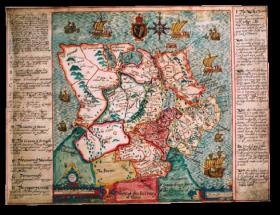
Francis Jobson’s ‘Ulster’ (c. 1598) provided representations of the Gaelic lordships in Ulster, but also imposed England’s vision for the creation of a new county system onto the provincial landscape. (Trinity College, Dublin)
An estimated 370 manuscript maps of Ulster survive, dating from roughly 1567 through to 1636, in fifteen repositories throughout Britain and Ireland. In Britain these include the National Archives, the British Library, the National Maritime Museum, the Guildhall Library, Drapers’ Hall, Goldsmiths’ Hall and Lambeth Palace Library (all in London); Longleat House, Wiltshire; Hatfield House, Hertfordshire; Cambridgeshire Record Office, Huntingdon; and Alnwick Castle, Northumberland. In Ireland extant maps are housed in the National Library of Ireland; Trinity College, Dublin; the Public Record Office of Northern Ireland; and the North Down Museum, Bangor.
This wide dispersal, as well as the public and private nature of these archives, suggests something of the diverse role of maps during the Ulster plantation and their use by both government officials and private estate-holders. For example, the State Papers collection at the National Archives comprises material sent to the Crown in response to requests for maps and as accompaniments to correspondence relating to Ulster. Other collections were commissioned by the landholders themselves. Thomas Raven, for example, undertook the Clandeboye Estate surveys, now at the North Down Museum, at the behest of Sir James Hamilton, Viscount Clandeboye, as he attempted to settle land boundary disputes with his neighbour Lord Montgomery (above).
This wide dispersal also makes these maps a rather challenging source to use, as many of the archives appear to be haphazard collections of numerous types of maps acquired by interested collectors and statesmen. In order to achieve a more nuanced understanding of their role as tools of plantation, it is necessary to study the entire corpus for the Ulster plantation. Map-making in Ulster reflects the different phases of England’s interaction with the province. Surviving maps can be grouped into three categories: reconnaissance surveys, including topographical and military maps; preparatory surveys such as the 1609 Bodley survey; and plantation maps that reflect the assigning of estates to undertakers, the establishment of the Londonderry proportions, monitoring the plantations, and urban and estate development.
Reconnaissance surveys
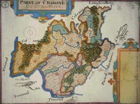
Josias Bodley’s ‘Parte of the Baronie of Strabane’ (1609), one of 28 surviving for baronies in counties Armagh, Tyrone, Fermanagh and Cavan.
(National Archives, London)
The first phase of mapping in Ulster began in the pre-plantation period. Following a 1567 request by Queen Elizabeth I ‘for plats of Ulster to be sent’ to aid in planting obedient subjects, map-makers began to provide provincial maps. One of the earliest in Ulster was Francis Jobson, who created provincial maps between 1591 and 1598. His maps are crucial to our understanding of England’s changing relationship with Ulster at the end of the sixteenth century. As the Nine Years’ War began, Jobson provided representations of the Gaelic lordships in Ulster, but also imposed England’s vision for the creation of a new county system onto the provincial landscape.
In Jobson’s 1598 map, now at Trinity College, Dublin (p. 42), this framing of the new political geography is obvious. Throughout Ulster, the various Gaelic lordships are denoted by the lord’s name and a line defining their boundary. Settlements such as castles and churches that could be integrated into English settlement plans are displayed by small replicas in red across the map. But what distinguishes this map as more than a mere representation of these lordships is the detailed inscription that frames it, acting as a legend to the map and describing England’s imperial plans for Ulster. A colour code, letter reference system and new county names spell out England’s intention to impose political structures in Ulster, thus effectively claiming Ulster for the Crown. England’s claims to Ulster became even more pronounced through Jobson’s use of a royal seal as an embellishment. The location of the seal at the top of the map, overlooking the whole of the province, gives symbolic representation to England’s view of Ulster as very much a part of the queen’s dominion. Consequently, Jobson’s map became a crucial means by which the English administrators who received and viewed it could envisage the province in its current political state and in a future structured and controlled landscape.
Preparatory surveys
Thomas Raven’s ‘Killelagh’ (1625/6), part of the Clandeboye estate survey carried out at the behest of Sir James Hamilton, Viscount Clandeboye, as he attempted to settle land boundary disputes with his neighbour, Lord Montgomery. (North Down Museum)
By 1609 England’s relationship with Ulster had changed significantly. Following the Flight of the Earls in 1607, preparations for plantation began. As part of this process, the Crown requested new surveys of the lands. In 1609 Sir Josias Bodley received a commission to map the boundaries of the new estates and to begin to establish the ‘shares for the undertakers’, taking note of the quality of the lands (bottom of p. 43). Each barony was to be mapped separately, and 28 maps now survive for counties Armagh, Tyrone, Fermanagh and Cavan in the National Archives in London. Two contemporary sketches and an engraving survive for Donegal in Trinity College, Dublin, while a larger map of the Ulster baronies at Hatfield House is believed to be the base map for the survey.
The use of the barony unit ensures that officials would have a detailed view of the cultural and physical landscape on the eve of plantation. In ‘Parte of the Baronie of Strabane’ Bodley pays particular attention to land boundaries. While he uses local Gaelic place-names and locates them using a red conventional symbol, he begins the process of plantation by dividing the landscape into the new plantation ‘proportions’. Thus these 1609 maps immediately became aids to the process of claiming and redistributing land during the Ulster settlement.
The barony format also enabled a more detailed study of the native buildings. Bodley only included churches and castles, reflecting those buildings that could be retained and integrated into the plantation landscape. In the Strabane proportion, for example, Strabane Castle is shown in perspective as a large fortified castle with two distinct wings, while church lands are displayed through the use of the colour green and small drawings of churches. In building up this picture of the cultural landscape, Bodley portrays the clash between Gaelic Ulster and Plantation Ulster. Through his maps, the English government obtained a view of how the province would be divided into the plantation grants, alongside the integration of certain aspects of the Gaelic cultural landscape.
Plantation maps
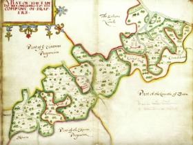
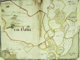
Thomas Raven’s ‘A Plat of the Lands belonging to the Company of Drapers’ (1622) focused on the outline of the company lands, contextualising them among the surrounding proportions and counties.
(Drapers’ Hall)
Following the completion of these initial preparatory surveys, the next step was to establish the plantation estates. At this point maps became an integral part of the practice of plantation on the ground, as tools to assign the plantation estates to the undertakers and to provide detailed descriptions of the new Londonderry proportions. As the plantation developed, new map categories emerged that sought to distinguish both urban and estate development. Maps monitoring the plantation became a key element of the 1622 commission in Ulster. Thomas Raven created the commission’s maps of Londonderry at the request of Sir Thomas Phillips, who had been appointed as a commissioner for counties Donegal and Londonderry. Two copies of the 1622 maps now survive at Drapers’ Hall and Lambeth Palace Library in London.
The survey begins with a general map of the Londonderry proportions, before providing two maps per company proportion, such as the Drapers’ proportion (pp 44 and 45). These maps focused on the outline of the company lands, contextualising them among the surrounding proportions and counties, before displaying the proportion in detail by depicting individual townlands and noting key settlements such as Monnymore. The second map shows the extent and quality of the Monnymore settlement. A large manor house, a mill and a small village dominate the image. Within the village, a market cross marks the junction of the four small roads of the town, along which linear settlement has grown. The houses display a distinct mix of architectural styles and are inscribed with the names of the owners. In the immediate foreground of the settlement thatched houses are depicted, perhaps representing the homes of Scottish settlers, or indeed the ‘deserving’ natives on the proportion. Thus from this map, on a purely visual level, Monnymore appears to be a thriving settlement that has fulfilled many of the requirements of the plantation.
On more detailed inspection, however, it becomes apparent that the image is far from accurate. The representation of the manor house, for example, shows a large three-storey house with a fortified bawn to the front. Yet the commentary within the map notes that the development
‘beinge neere finished lyes in part uncovered the flowers and partitions not made the timber thereof rotting and walls decayinge with the weather havinge so remained these six years and is now vsed for a pound for Cattell’.
An inscription added at a later point, however, in another hand states that ‘This house hath beene repaired since the Commissioners surveyed it’. This poor record of development is exacerbated by the small village to the foreground, where the occupancy of some of the houses is recorded as ‘voyd’. Such poor structural development, maintenance and settler numbers would undoubtedly have caused great concern among English authorities, who had hoped that strong settlements on the London Companies’ estates would aid in bringing stability to the troubled northern region.
Conclusion
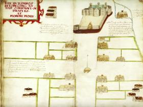
Thomas Raven’s ‘The buildings belonging to the Company of Drapers at Monnemore’ (1622) shows the extent and quality of the Monnymore settlement—or does it? (Drapers’ Hall)
The depth of material within the surviving map collections suggests that Ulster was the most extensively surveyed of all the Irish plantations. Of the 625 known maps, 370 relate to Ulster. As English officials became more involved with the plantation process, mapping underwent significant change, reflecting the phases of colonial interaction with the province. The maps offer a significant insight into the development of the plantation in Ulster. They reflect an attempt to record the changing landscape as it moved from native Gaelic structures to the English ideal of ordered, planted estates. In many instances these maps also appear as agents of control, as they attempted to offer a blueprint for the future development of the province along English lines. They offer a window on the settlement in Ulster, recording key features of the plantation, including architecture, land boundary changes, and urban and estate development. HI
Annaleigh Margey is an AHRC Research Fellow on the ‘1641 Depositions Project’ in the Department of History at the University of Aberdeen.
Further reading:
J.H. Andrews, Plantation acres: an historical study of the Irish land surveyor and his maps (Belfast, 1985).
N. Canny, Making Ireland British, 1580–1650 (Oxford, 2001).
A. Margey, ‘Representing plantation landscapes: the case of Ulster, c. 1560–1640’, in C. Rynne and J. Lytellton (eds), Plantation Ireland: settlement and material culture, c. 1550–1700 (Dublin, 2009).
A. Margey, Mapping Ireland, c. 1550–1640: an illustrated catalogue of the plantation maps of Ireland (Dublin, 2009).