The queen’s last map-maker: Richard Bartlett in Ireland, 1600–3
Published in Book Reviews, Early Modern History (1500–1700), General, Issue 6 (Nov/Dec 2009), Reviews, Volume 17The queen’s last map-maker: Richard Bartlett in Ireland, 1600–3
J. H. Andrews
(Geography Publications, Ä40)
ISBN 9780996602430
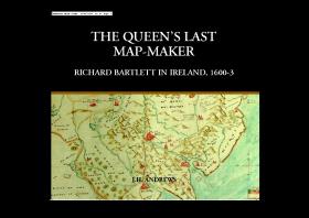 In the late 1990s I moved to Belfast, and on a visit to the Tower Museum in L/Derry I came across a bearded statue holding rolls of maps while looking dramatically into the distance. Ulster maps and borders were as relevant then as ever, so I looked a little closer—and was surprised to see that this surveyor/map-maker had the same surname as mine. Described by UCC Professor William J. Smyth as ‘the greatest artist/cartographer ever to work in Ireland’, Richard Bartlett’s story nonetheless ended violently in an unexplored part of the country sometime between 1603 and 1609, when it was reported by Sir John Davies that ‘. . . when he came to Tyrconnell the inhabitants took off his head, because they would not have their country discovered’.
Intrigued by his tragic fate I began my own research, but it quickly became clear that his personal life was largely unknown and that his maps weren’t fully identified or collected together either. The primary source then was the out-of-print Ulster and other Irish maps c. 1600 by G. A. Hayes-McCoy (Irish Manuscripts Commission, 1964), but more contemporary material was often authored by J. H. Andrews, and I keenly awaited the publication of this, the definitive book on Bartlett and his maps.
As a layman, I can readily admit that many people might find this a rather dry and academic work. There’s almost nothing known about Bartlett himself—expect that he was probably from Norfolk, East Anglia—so there’s little here to connect with on a personal level. That’s no surprise, though. This is no dramatic exercise: this is an exhaustive study specifically examining everything from the background to mapping early seventeenth-century Elizabethan Ireland, to the signs, symbols and colorisation of maps, to the land, people, measurement and place-names—as well as comparing the maps with those of other surveyors/cartographers from the period.
Andrews contrasts deeply to obtain full clarity, adding and subtracting pieces to Bartlett’s canon, looking in detail at their accuracy (good and bad) and adding new information post-McCoy (including a possible 1597 reference to Bartlett’s ‘skills’ and several years spent in Spain—was he a Catholic?). Bartlett’s maps were largely produced for military use in the pacifying of Ulster—the bulk of them feature forts and castles, since he was following the campaign of Charles Blount, Baron Mountjoy—but he also went further south and mapped the vital siege of Kinsale in 1601. Strangely, neither Bartlett nor his maps are ever mentioned in Fynes Moryson’s diary of the campaign despite numerous factors affecting his work that might have required assistance: lack of time, issues of safety, obtaining and moving equipment, and naming/renaming locations by talking to illiterate locals.
Bartlett’s trip some 400 years ago must have been a daunting yet thrilling challenge, and although some ethnographic and historical landscape features appeared for the first time in his maps, it’s a shame that his only personal feelings seemed—at least for me—to be found in some of his maps: swimming ducks, a man ferrying across the moat at Charlemont fort, and smoke coming from chimneys. His masterpiece is considered to be A generalle description of Ulster (1602/3), and although Andrews shows that it’s not as perfect as Bartlett might have hoped, for a man killed in a strange land that perhaps he had come to see as something more—85% of his nomenclature is in Gaelic—it serves as a fitting legacy. To quote writer Elizabeth Bowen: ‘Only the dispossessed people know their lands in the dark’.
Overall, it would have been preferable if Bartlett’s maps had been inserted throughout (instead of having to endlessly flip to the end of the book to check out every point), but the comparative lists of names—Bartlett’s and the modern/Irish equivalent—were especially interesting, and all the maps were evocative. In a world where most new cars have GPS fitted as standard and you can see almost any city, village, landmark and even individual people by simply logging on to Google Earth, it’s getting harder to imagine the concept of mapping at all. Over the years, one of Bartlett’s maps was lost at the printers and some ended up in the possession of a young child named Richard Bowlby, but now, happily, those interested in Irish history can view Bartlett’s historiography in their own home. HI
James Bartlett is a writer and journalist living in Los Angeles.