Reconstructing the seventeenth-century landscape of the Pale
Published in 1641 Rebellion, Early Modern History (1500–1700), Early Modern History Social Perspectives, Features, Issue 6 (Nov/Dec 2012), Volume 20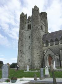
Lusk in north County Dublin was the site of a pre-Norman monastery and a medieval church. Its tower was already a long-established landmark in the 1650s.
When the lords of the Pale (as they continued to be styled in subsequent depositions) gathered at various hilltops in east Meath in October 1641, their dilemma was palpable. Should they continue to support an English state from which they were increasingly alienated in religion and in outlook, or should they make common cause with the great rebellion that had exploded across Ulster? They chose the latter and ultimately found themselves losers. It was well over a decade later before the dust began to settle on a great phase of turbulence and transformation in Irish history. The rebellion of 1641 precipitated a desperate struggle for the control of Ireland, which ended with Cromwell and the forces of the short-lived English Commonwealth in control.The lords of the Pale were the great landowning families of north County Dublin and east Meath: Preston of Gormanston, Barnwall of Turvey, Fleming of Slane and Fagan of Feltrim, to name but a few. Catholic and of Anglo-Norman stock, they were the ‘Old English’, in contrast to the Protestant ‘New English’ arrivals of the later sixteenth- and early seventeenth-century plantation period. Long-time supporters of the English colony, they had defended and maintained their district as a ‘land of peace’ during the decades and centuries when English rule was contested across much of Ireland. The landscape these power-brokers looked out upon from their hilltop meeting-place was their creation, the rich farmland of north Dublin and east Meath.
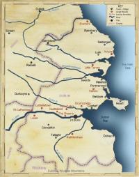
Map of north County Dublin/east Meath, showing main places in the 1650s. (Tomás Ó Brógáin)
The Pale countryside
North County Dublin and the adjacent baronies of County Meath are among those districts for which the parish records of both the Civil and Down surveys survive. Some very detailed information is therefore available on the landscape of the core area controlled by the lords of the Pale in the middle decades of the seventeenth century. The many prominent reminders of this area’s rich past include the impressive church sites of Swords, Lusk and Balrothery and the stark outline of Baldongan Castle near Skerries. Swords, like Lusk, was the site of an early monastery, now attested by a round tower, with the imprint of the monastic sanctuary still evident in the street plan. Later these sites were absorbed into the Anglo-Norman world. Swords, the centre of the archbishop of Dublin’s lands in north Dublin, became the site of an important castle and served as the main market centre of north Dublin. Today Swords continues to be the main service centre of the north county, its older parts now being enveloped by a girdle of big-shed architecture for shopping, warehousing and industry. Lusk is smaller but comparably enveloped, in this instance by a swathe of suburban housing.The Anglo-Norman impact had been significant and lasting in these core areas of the Pale. Unlike many parts of Ireland, here the manorial system, the centrepiece of rural feudalism, had put down roots, and so had the associated open-field agriculture. Across the largely hedgeless rolling landscape of north Dublin, the legacy of the Anglo-Normans was a complex pattern of landholding, with many of the smaller farmers working unenclosed strips of land dispersed across large fields. Those patterns were mostly reformed during the 1700s and 1800s, but the 1650s surveys indicate that feudal structures were then still strong. Although focusing on forfeited land and as a result selective, the Down Survey map for the bog-rich parish of Garristown in the north-west of the county is an especially expressive witness to the tenurial complexity that was embedded in the landscape. Further evidence comes from the very detailed descriptions that were needed to describe the limits of properties set in an open countryside lacking clear boundary features. It was especially difficult to identify holdings in the barony of Nethercross around Swords.
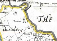
he ‘fishing town’ of New Haven (top, centre), just south of Bremore Head in north Dublin, as it appears on the Down Survey map for the barony of Balrothery.
As well as its maps, the Down Survey provides short commentaries that offer glimpses into local life and landscape. Nethercross is described as ‘not far remote’ from the city of Dublin, as a result of which the inhabitants are greatly advantaged ‘for furnishing themselves with provisions and necessaries’ and also for selling their produce. In nearby Meath, Ratoath is ‘an old town and ruined church with many thatcht houses and cabbins . . . a corn mill in repair. There is a market kept there on Mondays weekly which affords some provisions and linen cloth. There stands on the south side of the town an old Mount which in former times was a fortification . . .’. Dunboyne, a little to the south, is described as having ‘a ruined church the chancel only in repair, with an English-built Stone House with divers common houses and cabbins. A market is kept here . . .’. The description continues: ‘at the north end of the town by the high way stands a high ash tree seen over all or the most part of the barony, about which the country people used to dance on festival days’. The extent of sea-fishing activity along the coast is indicated in comments on Clontarf, Howth, Baldoyle, Portmarnock, Malahide, Rush, Skerries and New Haven. As well as identifying at Howth a ‘fair mansion house’, two castles and other buildings valued collectively at £600, the Civil Survey notices ‘a Harbour for small Barques to which there belongs several fishing boats . . . where the Lord of Hoath hath of every boat ye choice fish which is called ye Lords fish’. At Malahide the Down Survey observes ‘several thatched houses and cottages by the seaside where fishermen dwelleth’. At Rush, the poor fishermen and other inhabitants grazed their cattle upon the commons, a 100-acre area, mainly of sandy banks and hills. At Skerries dues were exacted as at Howth, with the tithe fish and customs fish (the best of each boat) going to the proprietor, as well as an anchorage charge of sixpence per vessel. The Down Survey is silent on Skerries, but a 1703 map shows a cluster of buildings beside the present fishing harbour. New Haven, in contrast, was less durable. Situated on the property of Matthew Barnwall at Bremore, north of Balbriggan, it was no longer in existence when the Ordnance Survey maps were made in the 1830s.
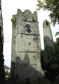
The round tower and medieval priest’s tower at Swords, landmarks in the mid-seventeenth century and reminders of the long history of the largest centre in the north county.
The built environment
One of the most interesting aspects of the Down and Civil surveys is their information on the built environment. Exactly what is included can vary between baronies, as different surveyors, interpreting their instructions in varying ways, were sometimes involved. A particularly fine Civil Survey record is available for north County Dublin, covering, and also valuing, a wide range of buildings. As with several other areas for which the survey survives, many stone buildings are recorded—houses, mills, churches, chapels and bridges, for example. The state of these buildings, whether in repair or ruined, is also noticed. But what makes the north county distinctive is the extension of the record to take in many farm outbuildings—barns, stables and pigeon houses, among others—and the inclusion of the smaller dwellings, the thatched houses, cottages and cabins, in which the ordinary people lived. Outstandingly, the Civil Survey records the north county and some adjacent parts of Meath as having the structures of a land of peace. Across the less-secure south county, the Civil and Down surveys together record over 50 ‘castles’ (strongly fortified buildings including tower-houses), the majority in repair and still serving as principal residences. The 33 castles (eighteen being ruined or old) in the north county compare with over 200 less-fortified buildings identified as high-valuation stone and mansion houses, farmhouses and just plain houses. A further 600–1,000 structures of much lower valuation (normally £10 or under) are recorded as ‘thatched houses’, ‘cottages’, ‘cabins’ and ‘chaff houses’. In addition, the survey identifies 177 farm buildings, 79 orchards, fourteen quarries, nine rabbit warrens, 39 mills of various types and two salmon weirs. Some 28 churches and nineteen chapels are also noted but, perhaps indicative of the contemporary religious flux, a majority of these were old or ruined.The overall picture that emerges is of a countryside with a wide distribution of small clusters of small thatched dwellings and a much lesser number of substantial large houses. Many of the more humble thatched buildings were probably constructed of mud walls and lacked chimneys. Maps of the Ratoath area, possibly drawn by one of the Down Survey cartographers about 1659, show a mix of buildings with and without chimneys. When enlarged, these seemingly casual sketches give some vivid imagery of the small clusters in which most people lived.The larger houses, in contrast, were mainly in stone, with a few in brick and possibly some old timber structures. A few—for example, the now-demolished Drynam near Swords—are characterised as built ‘in the English style’. Around 60 buildings (along with their various outhouses) were accorded valuations over £100, with nine over £500. Some of the most significant buildings were along the Liffey valley (at Chapelizod, the Phoenix, Luttrellstown, Lucan and St Catherine’s), or else close to the city, as at Little Cabra (valued the highest at £1,400) and Drumcondra, or at or near the coast (Howth, Malahide, Kenure, little Turvey). Some of these were on old-established sites, with an old castle alongside a newer stone house and a significant number of out-offices. The availability of surplus investment capital is suggested by 26 references to groups of trees ‘set for ornament’, an indication that, like their counterparts in England, the wealthy could take an interest in aesthetic aspects of their surroundings.
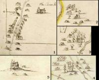
Clockwise from top: Enlarged images from County Meath maps drawn c. 1659 show a range of building types: (1) Ratoath village (note the inn denoted by the flag); (2–4) small clusters of buildings, with and without chimneys, at Littlelagore and Flemingstown near Ratoath, and Piercetown near Dunboyne; (5) a fortified castle near Rathmolyon, at the edge of the old Pale. (British Library)
The idea of a settled, well-organised countryside is given further credence by the extensive scatter of corn mills. Most were water-powered, but there were also four windmills, two tidal mills and two horse-mills. The Down Survey map provides an early glimpse of one of the most famous landmarks of the north county, the windmill on Feltrim hill near Malahide. In neighbouring Meath, a further 162 mills are recorded in the Civil Survey across the county, with around twenty, most of them in the less secure north-west, specifically listed as out of repair or ruined. As in north Dublin, the spread and density of these structures suggests an organised, settled landscape. Turbulence and great privation had been experienced since the fateful decision of 1641, the properties of the great lords had been threatened and the struggle for religious allegiance continued, yet the Civil and Down surveys also suggest that other daily rhythms, lifestyles and residences may have experienced little permanent change. Much more significant for the general population would be the agricultural adjustments of later decades, changes that saw much of the Dublin region reorganised for low-labour grazier farming. A contrast then emerged between the more tillage-oriented farming of north County Dublin and the large grazier cattle farms of a depopulated south Meath. These developments were only just appearing on the horizon in the mid-seventeenth century. HI
Arnold Horner is an independent researcher who formerly lectured in geography at University College Dublin.
Further reading:
F.H.A. Aalen & K. Whelan (eds), Dublin city and county: from prehistory to present (Dublin, 1992).E. MacLysaght, Irish life in the seventeenth century (Cork and Oxford, 1939 and later). W.J. Smyth, Map-making, landscapes and memory: a geography of colonial and early modern Ireland c. 1530–1750 (Cork, 2006).1641 depositions (www.1641.tcd.ie/).